Expansion of Agricultural Activities for 19.8 Ha of Citrus Orchards on Farm 960, Patensie
Draft Basic Assessment Report in terms of the Environmental Impact Assessment Regulations, 2014, promulgated in terms of the National Environmental Management Act, 1998(Act No. 107 of 1998), as amended
DEDEAT Ref: EC08/C/LN3/M/70-2014
Prepared by: Engineering Advice & Services (Pty) Ltd
73 Heugh Road, Walmer, Port Elizabeth, 6013
Tel: +27 (0) 41 581 2421, Fax: +27 (0) 86 683 9899
 |
18 May 2015
|
|
BASIC ASSESSMENT REPORT (For official use only) |
|
File Reference Number: |
|
|
Application Number: |
|
|
Date Received: |
|
PROJECT TITLE
|
Expansion of agricultural activities on Farm 960, Patensie for cultivation of Citrus: DEDEAT Ref: EC08/C/LN3/M/70-2014 |
Basic assessment report in terms of the Environmental Impact Assessment Regulations, 2014, promulgated in terms of the National Environmental Management Act, 1998(Act No. 107 of 1998), as amended.
Kindly note that:
- This basic assessment report is a standard report that may be required by a competent authority in terms of the EIA Regulations, 2014 and is meant to streamline applications. Please make sure that it is the report used by the particular competent authority for the activity that is being applied for.
- The report must be typed within the spaces provided in the form. The size of the spaces provided is not necessarily indicative of the amount of information to be provided. The report is in the form of a table that can extend itself as each space is filled with typing.
- Where applicable tick the boxes that are applicable or black out the boxes that are not applicable in the report.
- An incomplete report may be returned to the applicant for revision.
- The use of “not applicable” in the report must be done with circumspection because if it is used in respect of material information that is required by the competent authority for assessing the application, it may result in the rejection of the application as provided for in the regulations.
- This report must be handed in at offices of the relevant competent authority as determined by each authority.
- No faxed or e-mailed reports will be accepted.
- The report must be compiled by an independent environmental assessment practitioner (EAP).
9. Unless protected by law, all information in the report will become public information on receipt by the competent authority. Any interested and affected party should be provided with the information contained in this report on request, during any stage of the application process.
10. A competent authority may require that for specified types of activities in defined situations only parts of this report need to be completed.
Section A: Activity information
|
Has a specialist been consulted to assist with the completion of this section? |
YES |
NO |
|
If YES, please complete form XX for each specialist thus appointed: |
||
Any specialist reports must be contained in Appendix D.
1. Activity DESCRIPTION
Describe the activity, which is being applied for, in detail
|
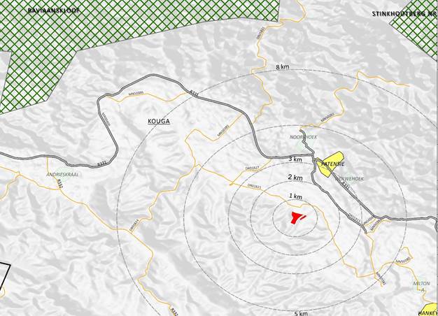
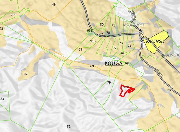
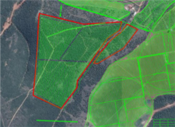
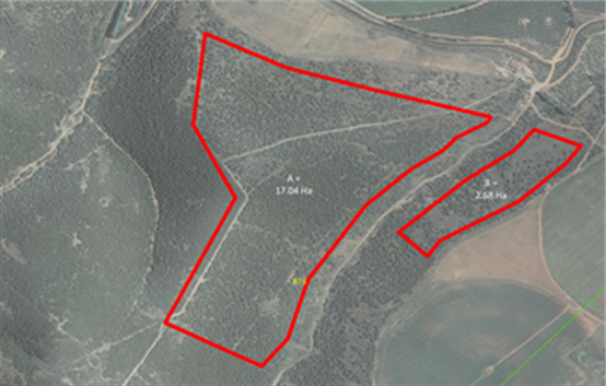
Introduction The applicant, Mr Grant du Preez (AIN du Preez Boerdery) intends to expand the existing citrus cultivation on Farm 960 (~270,0435 ha in extent) by establishing approximately 19.8 hectares for additional citrus orchards and associated agricultural infrastructure. The site under assessment is located on an existing farm (Farm 960), currently zoned for Agricultural Use, south-east of Patensie, in the Kouga Local Municipality. The farm is currently utilised for a variety of activities, namely, citrus production and vegetable cultivation. The applicant intends expanding and improving the existing citrus cultivation on Farm 960 (~270 0435 ha in extent) by establishing approximately 19.8 hectares for additional citrus orchards and associated agricultural infrastructure. The area proposed for development is located centrally within the farm. The proposed additional orchards can be readily tied into the access and irrigation infrastructure of the existing farming operations. The farm portion that forms part of this assessment is currently zoned for agriculture. The proposed development will entail the following activities on the site:
Once the necessary infrastructure has been established, the area will be used for the cultivation of citrus crops. The applicant proposes to use existing offices and service buildings on the farm, thus negating the need for any additional associated services infrastructure such as electricity and sanitation, other than the water required for the irrigation of the crops. The applicant has indicated that an existing storage dam located east of the area under assessment has sufficient capacity to provide water to the development, thus negating the need for the establishment of a dam or expansion of the existing dam. This will be confirmed through the environmental assessment process. The final design and layout of the development will be informed by technical and environmental specialist input during the Basic Assessment process.
The applicant is a member of the Hankey Citrus Packers (Pty) Ltd and during harvesting season, citrus is transported directly from the farm to the packing plant for processing, packaging and export. The project will thus not require any additional infrastructure (e.g. buildings, offices, and sanitation) associated with the processing and packaging of the citrus. The project will however require the installation of drip/ micro irrigation infrastructure as well as the use of an existing water storage dam, for which a 24 G application is being applied. Approvals were however obtained from the Department of Water Affairs and the Gamtoos Irrigation Board.
Locality & Town Planning
Site Overview A portion of approximately 60 Ha is currently being used for citrus and the cultivation of vegetables. There are a few cut lines and vehicle tracks through the area under assessment, where vegetation has been removed, but, for the most part, it is predominantly covered by intact Thicket vegetation. The area under assessment is currently stocked with small indigenous game, including Kudu, Duiker and Bushbuck, and is utilised for cattle grazing.
A drainage line originates in the north-eastern portion of the area under assessment and flows in a south westerly direction along the northern boundary.
Surrounding Land-use
Project Overview The project can be divided into the following stages/phases:
It is important to note that a preparation phase (preconstruction and construction) is required prior to harvesting for export. This period varies dependent on the variety of the crop being produced.
PRECONSTRUCTION PHASE The fruit proposed to be produced on the site is for international export. In order to meet the requirements of export stock, seed (block seed) is required to be booked and purchased from a certified agency. This is booked approximately two years in advance in order to secure the seed and includes a financial deposit.
The seed is provided to a certified nursery for a grow-out period, during which the seeds are germinated and the seedlings grown to sapling stage. Meticulous coordination is required between the Citrus Foundation for the purchase of the seed, the nursery for grow-out, and the citrus producer, in order to meet contractual obligations for harvesting and export of the crop.
This is an on-going process, which is carefully timed and coordinated to allow the phased development of a site to take place. The preconstruction phase for securing the block seed and growing of the saplings occurs in parallel to site preparation which is outlined below. Site preparation needs to be completed to coincide with the planting of the crop, which occurs annually in the last quarter of the year between ideally November and January. Thus the timing between the purchase of the seedlings, preparation of the site and planting of the crop for harvesting and export is critical.
CONSTRUCTION PHASE The project will entail the clearing of vegetation, levelling of the site, the installation of the drip/ micro irrigation system and the expansion of the existing water storage dam, prior to the planting of a variety of citrus saplings.
The project will thus entail the following activities on the site:
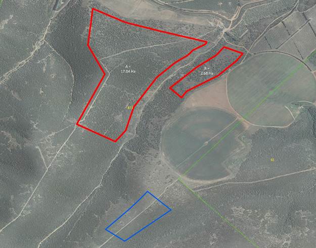
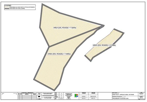
Clearing of vegetation It is proposed that approximately 9.8 ha of vegetation is removed from the area under assessment to facilitate the development of the site for the cultivation of a variety of citrus crops. Portions of the area under assessment have been excluded from development due to certain biophysical constraints. This is discussed in more detail in Section B.
Shaping and earthworks Shaping and earthworks will be necessary in order to manage runoff from the cultivated lands and prepare the site for the establishment of the orchards. Contoured ridges will be constructed in a manner that will manage runoff.
Storage dam An existing storage dam (12 500 L) located north-east of the area under assessment is deemed to have sufficient capacity to provide water to the development, thus negating the need for the establishment of a new dam.
Internal roads The
development does not require formal surfaced roads, however reliable vehicle
access needs to be maintained to the cultivated area. It is anticipated that
this will be achieved by creating and maintaining vehicle tracks (< 5m)
between orchards to allow access for vehicles and equipment. Access to the
area can be provided by connecting the proposed internal roads with the
existing internal road network serving the adjacent agricultural activities.
As far as possible
Irrigation Irrigation water will be reticulated within the cultivated area via a network of irrigation pipes and valves. Water will be supplied to the orchards via underground PVC pipes with diameters ranging from 50 mm to 300 mm. Water delivery to trees will be achieved with the aid of aboveground polypropylene pipes providing micro and/or drip irrigation.
Planting of windbreaks No Windbreaks are anticipated at this stage. It is an accepted practice to establish exotic species as wind-breaks in the citrus orchards in the Gamtoos River valley. However these trees are listed in Category 3 of the Regulations in terms of the Conservation of Agricultural Resources Act (Act 43 of 1983). According to these regulations; propagative material of these plants, such as seeds or cuttings, may no longer be planted, propagated, imported, bought, sold or traded in any way. It is recommended that a tree species, which is not listed as invasive in terms of the CARA Regulations, is selected for planting as windbreak. The preferred species for use as windbreaks at the proposed farm are indigenous Yellowwood trees (Podocarpus sp.); or exotic Beefwood trees (Casuarina sp.), depending on availability. Should exotic Beefwood trees be selected as the preferred option, all the CARA requirements regarding the use of these trees should be adhered to.
Planting and Labour It is anticipated that vegetation clearing, landscaping, construction and planting will be done both by hand and with the aid of suitable earth moving equipment (excavators, bulldozers, TLBs). Site preparation will be undertaken by a bush clearing contractor. No site preparation phase workers’ accommodation will be provided at the site. Some existing accommodation facilities are in the process of being upgraded for existing and potential new workers.
OPERATIONAL PHASE Crop cultivation Once established, the orchards will be used to cultivate a number of citrus varieties. Crop watering will be achieved by drip irrigation which reduces water loss through evaporation, and thus reduces the water requirements of the development.
Water Use and Availability Water for the additional agricultural area will be provided from the canal system belonging to the the Gamtoos Irrigation Board. The citrus expansion will be irrigated using existing water use rights. Written confirmation of the availability of water to service the area has been received from Mr P. Joubert of the Gamtoos Irrigation Board (attached in Appendix G). Water will be pumped from the canal system to an existing onsite dam, located south east of the area under assessment, from where it will be reticulated via a system of underground PVC pipes to the orchards for micro and/or drip irrigation. The water use entitlements for Farm 960 amounts to 42.3 ha of water. This is the equivalent of approximately 338 400 m³ of water that is available for the farm and translates to an actual availability of water to sustain approximately 63.75 Ha of citrus. Currently existing operations make use of 40 ha of the abovementioned water rights per annum. Therefore the applicant still has capacity to irrigate approximately 23 Ha of citrus. The proposed development will require water sufficient for 19.8 ha of citrus annually. Therefore there is still sufficient capacity available to meet the irrigation water requirements for the farm. Supporting information for the determination of the above is included in Appendix G).
Employment Creation Planting and harvesting are done manually and are labour intensive processes. It is estimated that the development will create an additional # direct permanent employment opportunities, # indirect permanent employment opportunities and an additional 75 seasonal employment opportunities (# months of the year). Thus an additional income into the local market from permanent and seasonal employment opportunities is estimated at approximately R 335 000 annually. It is estimated the capital investment of the development will be R5 000 000. Labour will be sourced locally from communities in the Kouga Municipality.
Chemical use and storage It is anticipated that the cultivation of crops on the proposed site will require the use of additional agricultural chemicals such as fertilisers, herbicides and pesticides. No agricultural chemicals are proposed for storage on the area proposed for the agricultural expansion. The chemicals associated with the orchards will be stored in the existing storage facilities on the farm. The storage and use of agricultural chemicals will be in line with existing legislation governing these practices.
Supporting Infrastructure (potable water, sanitation, administration) No additional infrastructure is proposed on the area planned for expansion. The existing administrative and technical infrastructure on the farm will be utilised to service the expanded agricultural activities (offices, storage areas, and service buildings). The existing sanitation facilities on the farm will be used during the day to day maintenance of the orchards and associated infrastructure. During harvesting when there is a larger labour force present at the site, portable sanitation and washing facilities need to be provided.
Project Timeframes As noted in the section above on the project overview the project timing is determined back from the most suitable period for planting, which is between November and January annually. However, prior to the planting of the crops a period of preparation (construction and installation of infrastructure) is required. Should Environmental Authorisation for the project be issued, it is anticipated that the applicant will secure the necessary permits and authorisations within the following 12 months where after he will commence with site preparation. It is anticipated that the proposed agricultural development will be completed within 24 months of commencement.
Thus including the period for receipt of the permits; site preparation and cultivation is anticipated to be over a three (3) year period from the issuing of the environmental authorisation. |
2. FEASIBLE AND REASONABLE ALTERNATIVES
“alternatives”, in relation to a proposed activity, means different means of meeting the general purpose and requirements of the activity, which may include alternatives to—
(a) the property on which or location where it is proposed to undertake the activity;
(b) the type of activity to be undertaken;
(c) the design or layout of the activity;
(d) the technology to be used in the activity;
(e) the operational aspects of the activity; and
(f) the option of not implementing the activity.
Describe alternatives that are considered in this application. Alternatives should include a consideration of all possible means by which the purpose and need of the proposed activity could be accomplished in the specific instance taking account of the interest of the applicant in the activity. The no-go alternative must in all cases be included in the assessment phase as the baseline against which the impacts of the other alternatives are assessed. The determination of whether site or activity (including different processes etc.) or both is appropriate needs to be informed by the specific circumstances of the activity and its environment. After receipt of this report the competent authority may also request the applicant to assess additional alternatives that could possibly accomplish the purpose and need of the proposed activity if it is clear that realistic alternatives have not been considered to a reasonable extent.
|
Layout Alternatives Layout 1: not preferred
Preferred Layout The preferred layout takes into account a slightly wider buffer around the drainage line (20m to 35 m) betweeen the two planting areas. Although the site assessment determined that this should not be considered a water course, as a cautious measure, it has been recommended that a strip of natural vegetation be retained. This will mitigate erosion and runoff but also serve as a natural wind-break and faunal corridor.
In addition the planting plan has been modified slightly so that contours will be most effective to mitigate against runoff and erosion. |
Paragraphs 3 – 13 below should be completed for each alternative.
3. Activity POSITION
Indicate the position of the activity using the latitude and longitude of the centre point of the site for each alternative site. The co-ordinates should be in degrees and decimal minutes. The minutes should have at least three decimals to ensure adequate accuracy. The projection that must be used in all cases is the WGS84 spheroid in a national or local projection.
List alternative sites if applicable.
|
Alternative: |
Latitude (S): |
Longitude (E): |
||
|
Alternative S1[1] ( |
33o |
47.059‘ |
24o |
48.105‘ |
|
Alternative S2 (if any) |
o |
‘ |
o |
‘ |
|
Alternative S3 (if any) |
o |
‘ |
o |
‘ |
|
Alternative: |
Latitude (S): |
Longitude (E): |
||
|
Alternative S1 (preferred or only route alternative) |
|
|
|
|
|
· Starting point of the activity |
o |
‘ |
o |
‘ |
|
· Middle point of the activity |
o |
‘ |
o |
‘ |
|
· End point of the activity |
o |
‘ |
o |
‘ |
|
Alternative S2 (if any) |
|
|
|
|
|
· Starting point of the activity |
o |
‘ |
o |
‘ |
|
· Middle point of the activity |
o |
‘ |
o |
‘ |
|
· End point of the activity |
o |
‘ |
o |
‘ |
|
Alternative S3 (if any) |
|
|
|
|
|
· Starting point of the activity |
o |
‘ |
o |
‘ |
|
· Middle point of the activity |
o |
‘ |
o |
‘ |
|
· End point of the activity |
o |
‘ |
o |
‘ |
4. Physical size of the activity
Indicate the physical size of the preferred activity/technology as well as alternative activities/technologies (footprints):
|
Alternative: |
|
Size of the activity: |
|
Alternative A1[2] (preferred activity alternative) |
|
184 200 m2 |
|
Alternative A2 (if any) |
|
m2 |
|
Alternative A3 (if any) |
|
m2 |
or, for linear activities:
|
Alternative: |
|
Length of the activity: |
|
Alternative A1 (preferred activity alternative) |
|
m |
|
Alternative A2 (if any) |
|
m |
|
Alternative A3 (if any) |
|
m |
Indicate the size of the alternative sites or servitudes (within which the above footprints will occur):
|
Alternative: |
|
Size of the site/servitude: |
|
Alternative A1 (preferred activity alternative) |
|
27 700 435m2 |
|
Alternative A2 (if any) |
|
m2 |
|
Alternative A3 (if any) |
|
m2 |
5. Site Access
|
Does ready access to the site exist? |
YES |
NO |
|
|
If NO, what is the distance over which a new access road will be built |
m |
||
|
Describe the type of access road planned:
|
|
|
|
|
Existing Access Roads from adjacent orchards to the north will be extended and upgraded to provide acceptable access to the site. Refer to detailed site plans in Appendix A. |
|||
Include the position of the access road on the site plan and required map, as well as an indication of the road in relation to the site.
6. SITE OR ROUTE PLAN
A detailed site or route plan(s) must be prepared for each alternative site or alternative activity. It must be attached as Appendix A to this document.
The site or route plans must indicate the following:
6.1 the scale of the plan which must be at least a scale of 1:500;
6.2 the property boundaries and numbers of all the properties within 50 metres of the site;
6.3 the current land use as well as the land use zoning of each of the properties adjoining the site or sites;
6.4 the exact position of each element of the application as well as any other structures on the site;
6.5 the position of services, including electricity supply cables (indicate above or underground), water supply pipelines, boreholes, street lights, sewage pipelines, storm water infrastructure and telecommunication infrastructure;
6.6 all trees and shrubs taller than 1.8 metres;
6.7 walls and fencing including details of the height and construction material;
6.8 servitudes indicating the purpose of the servitude;
6.9 sensitive environmental elements within 100 metres of the site or sites including (but not limited thereto):
§ rivers;
§ the 1:100 year flood line (where available or where it is required by DWA);
§ ridges;
§ cultural and historical features;
§ areas with indigenous vegetation (even if it is degraded or invested with alien species);
6.9 for gentle slopes the 1 metre contour intervals must be indicated on the plan and whenever the slope of the site exceeds 1:10, the 500mm contours must be indicated on the plan; and
6.10 the positions from where photographs of the site were taken.
7. Site PHOTOGRAPHS
Colour photographs from the centre of the site must be taken in at least the eight major compass directions with a description of each photograph. Photographs must be attached under Appendix B to this form. It must be supplemented with additional photographs of relevant features on the site, if applicable.
8. FACILITY ILLUSTRATION
A detailed illustration of the activity must be provided at a scale of 1:200 as Appendix C for activities that include structures. The illustrations must be to scale and must represent a realistic image of the planned activity. The illustration must give a representative view of the activity.
9. ACTIVITY MOTIVATION
9(a) Socio-economic value of the activity
|
What is the expected capital value of the activity on completion? |
R 5 000 000 |
|
|
What is the expected yearly income that will be generated by or as a result of the activity? |
R 3 000 000 |
|
|
Will the activity contribute to service infrastructure? |
YES |
NO |
|
Is the activity a public amenity? |
YES |
NO |
|
How many new employment opportunities will be created in the development phase of the activity? |
- |
|
|
What is the expected value of the employment opportunities during the development phase? |
- |
|
|
What percentage of this will accrue to previously disadvantaged individuals? |
100 % |
|
|
How many permanent new employment opportunities will be created during the operational phase of the activity? |
130 |
|
|
What is the expected current value of the employment opportunities during the first 10 years? |
R 3 350 000 |
|
|
What percentage of this will accrue to previously disadvantaged individuals? |
100 % |
|
9(b) Need and desirability of the activity
Motivate and explain the need and desirability of the activity (including demand for the activity):
|
The farm under assessment is zoned for Agriculture in terms of the Zoning Scheme promulgated under section 8 of LUPO (1985) and the properties surrounding the site are engaged in extensive (grazing and rangeland) or intensive (citrus orchards) agricultural activities. Soil suitability studies conducted have ascertained that the site is suitable for agriculture, in particular for the establishment of citrus. The area proposed for the expansion of the agricultural activities is located on an established farm that is engaged in a number of agricultural activities including citrus production. Therefore the proposed development can readily tie into the existing administrative infrastructure of the current farming operation. In addition, the applicant has water use entitlements for the farm which are currently not utilised. Once established, it is anticipated that the orchards will produce in excess of ### tons of fruit annually. The plantation will ensure sustainability of the current farming operations and the optimal use of already established infrastructure and operations. |
Indicate any benefits that the activity will have for society in general:
The project will provide economic stimulation in the Kouga Local Municipality, through the increased demand for goods and services associated with increased agricultural production. These include, among others: higher demand for packing materials (pallets, cardboard boxes, ink); increased shipping and cargo handling requirements; increased demand in agrichemical, fertiliser and supporting industries; as well as increased transport requirements for goods and labour. The development will also make a substantial contribution to the Kouga Local Municipality rates base; improving the capacity for service delivery to residents in the respective municipality.
Indicate any benefits that the activity will have for the local communities where the activity will be located:
The 2013 Final IDP for Kouga Local Municipality indicates that the unemployment rate for the Municipality is around 21.3 (2011). The proposed development will create an additional approximately 30 permanent and 100 temporary (seasonal) employment opportunities and will assist in skills development of these local communities.
The employment opportunities that will be generated by the proposed development will improve the buying power of individuals in the local communities, which in turn, may provide a boost for the local economy and enable these individuals to improve their standard of living.
10. Applicable legislation, policies and/or guidelines
|
4. The construction of a road wider than 4 metres with a reserve less than 13,5 metres. (a) In Eastern Cape… ii. Outside urban areas, the following: (ee) Critical biodiversity areas as identified in systematic biodiversity plans adopted by the competent authority or in bioregional plans |
Department of Economic Development, Environmental Affairs and Tourism (DEDEAT) |
|
|
13. The clearance of an area of 1 hectare or more of vegetation where 75% or more of the vegetative cover constitutes indigenous vegetation… (a) Critical biodiversity areas and ecological support areas as identified in systematic biodiversity plans adopted by the competent authority. |
Department of Economic Development, Environmental Affairs and Tourism (DEDEAT) |
|
|
14. The clearance of an area of 5 hectares or more of vegetation where 75% or more of the vegetative cover constitutes indigenous vegetation... (a) In Eastern Cape…: i. All areas outside urban areas. |
Department of Economic Development, Environmental Affairs and Tourism (DEDEAT) |
|
11. Waste, effluent, emission and noise management
11(a) Solid waste management
|
Will the activity produce solid construction waste during the construction/initiation phase? |
YES |
NO |
|
If yes, what estimated quantity will be produced per month? |
2 m3 |
|
|
How will the construction solid waste be disposed of (describe)? |
|
|
|
Waste material produced during construction may include biodegradable wood, wire, metal and plastic. Construction waste will be reused or recycled on site as far as possible. Waste that cannot be reused or recycled will be disposed of off-site at an appropriately registered/licenced waste disposal facility. |
||
|
Where will the construction solid waste be disposed of (describe)? |
|
|
|
Patensie Waste Disposal Site |
||
|
Will the activity produce solid waste during its operational phase? |
YES |
NO |
|
If yes, what estimated quantity will be produced per month? |
5 m3 |
|
|
How will the solid waste be disposed of (describe)? |
|
|
|
It is expected that an average of approximately 5 m3 of waste will be generated every month during the operational phase of the proposed project. This may include biodegradable plant material, which will be left in the orchards to decompose after harvesting. In additional it is expected that there may be some non-biodegradable containers from herbicides and pesticides used. |
||
|
Where will the solid waste be disposed if it does not feed into a municipal waste stream (describe)? |
||
|
Herbicide and Pesticide containers will be disposed of at an appropriately registered waste disposal facility (e. Patensie Waste Disposal site). Biodegradable waste will be left to decompose on site. |
||
|
If the solid waste (construction or operational phases) will not be disposed of in a registered landfill site or be taken up in a municipal waste stream, then the applicant should consult with the competent authority to determine whether it is necessary to change to an application for scoping and EIA. |
||
|
Can any part of the solid waste be classified as hazardous in terms of the relevant legislation? |
YES |
NO |
|
If yes, inform the competent authority and request a change to an application for scoping and EIA. |
||
|
Is the activity that is being applied for a solid waste handling or treatment facility? |
YES |
NO |
|
If yes, then the applicant should consult with the competent authority to determine whether it is necessary to change to an application for scoping and EIA. |
||
11(b) Liquid effluent
|
Will the activity produce effluent, other than normal sewage, that will be disposed of in a municipal sewage system? |
YES |
NO |
|||
|
If yes, what estimated quantity will be produced per month? |
m3 |
||||
|
Will the activity produce any effluent that will be treated and/or disposed of on site? |
Yes |
NO |
|||
|
If yes, the applicant should consult with the competent authority to determine whether it is necessary to change to an application for scoping and EIA. |
|||||
|
Will the activity produce effluent that will be treated and/or disposed of at another facility? |
YES |
NO |
|||
|
If yes, provide the particulars of the facility: |
|
|
|||
|
Facility name: |
|
||||
|
Contact person: |
|
||||
|
Postal address: |
|
||||
|
Postal code: |
|
||||
|
Cell: |
|
||||
|
E-mail: |
|
Fax: |
|
||
|
Describe the measures that will be taken to ensure the optimal reuse or recycling of waste water, if any: |
|||||
|
|
|||||
11(c) Emissions into the atmosphere
|
Will the activity release emissions into the atmosphere? |
YES |
NO |
|
If yes, is it controlled by any legislation of any sphere of government? |
YES |
NO |
|
If yes, the applicant should consult with the competent authority to determine whether it is necessary to change to an application for scoping and EIA. |
|
|
|
If no, describe the emissions in terms of type and concentration: |
|
|
|
|
||
11(d) Generation of noise
|
Will the activity generate noise? |
YES |
NO |
|
If yes, is it controlled by any legislation of any sphere of government? |
YES |
NO |
|
If yes, the applicant should consult with the competent authority to determine whether it is necessary to change to an application for scoping and EIA. |
|
|
|
If no, describe the noise in terms of type and level: |
|
|
|
The proposed activity will generate noise during the construction phase, when heavy plant machinery will be operating on site. Noise during the operational phase will be limited to normal sounds generated by agricultural activity, such as tractor and vehicular movements during maintenance and harvesting in the orchards. Since the site is surrounded by agricultural land, it is unlikely that the proposed agricultural development will have any noise impacts that could adversely impact adjacent landowners. The applicatnt will be required to adhere to applicable noise limits. |
||
12. WATER USE
Please indicate the source(s) of water that will be used for the activity by ticking the appropriate box(es)
|
municipal |
water board |
groundwater |
river, stream, dam or lake |
other |
the activity will not use water |
||
|
If water is to be extracted from groundwater, river, stream, dam, lake or any other natural feature, please indicate |
|||||||
|
the volume that will be extracted per month: |
0 litres |
||||||
|
Does the activity require a water use permit from the Department of Water Affairs? |
YES |
NO |
|||||
|
If yes, please submit the necessary application to the Department of Water Affairs and attach proof thereof to this application if it has been submitted. |
|||||||
|
|
|||||||
13. ENERGY EFFICIENCY
|
Describe the design measures, if any, that have been taken to ensure that the activity is energy efficient: |
|
Not applicable |
|
Describe how alternative energy sources have been taken into account or been built into the design of the activity, if any: |
|
Not applicable |
Section B: SITE/area/PROPERTY description
Important notes:
- For linear activities (pipelines, etc) as well as activities that cover very large sites, it may be necessary to complete this section for each part of the site that has a significantly different environment. In such cases please complete copies of Section C and indicate the area, which is covered by each copy No. on the Site Plan.
|
Section C Copy No. (e.g. A): |
|
2. Paragraphs 1 - 6 below must be completed for each alternative.
|
3. Has a specialist been consulted to assist with the completion of this section? |
YES |
NO |
|
If YES, please complete form XX for each specialist thus appointed: |
||
|
All specialist reports must be contained in Appendix D. |
||
1. GRADIENT OF THE SITE
Indicate the general gradient of the site.
Alternative S1:
|
Flat |
1:50 – 1:20 |
1:20 – 1:15 |
1:15 – 1:10 |
1:10 – 1:7,5 |
1:7,5 – 1:5 |
Steeper than 1:5 |
Alternative S2 (if any):
|
Flat |
1:50 – 1:20 |
1:20 – 1:15 |
1:15 – 1:10 |
1:10 – 1:7,5 |
1:7,5 – 1:5 |
Steeper than 1:5 |
Alternative S3 (if any):
|
Flat |
1:50 – 1:20 |
1:20 – 1:15 |
1:15 – 1:10 |
1:10 – 1:7,5 |
1:7,5 – 1:5 |
Steeper than 1:5 |
2. Location in landscape
Indicate the landform(s) that best describes the site:
2.1 Ridgeline
2.2 Plateau
2.3 Side slope of hill/mountain
2.4 Closed valley
2.5 Open valley
2.6 Plain
2.7 Undulating plain / low hills
2.8 Dune
2.9 Seafront
3. Groundwater, Soil and Geological stability of the site
Is the site(s) located on any of the following (tick the appropriate boxes)?
|
|
Alternative S1: |
|
Alternative S2 (if any): |
|
Alternative S3 (if any): |
|||
|
Shallow water table (less than 1.5m deep) |
YES |
NO |
|
YES |
NO |
|
YES |
NO |
|
Dolomite, sinkhole or doline areas
|
YES |
NO |
|
YES |
NO |
|
YES |
NO |
|
Seasonally wet soils (often close to water bodies) |
YES |
NO |
|
YES |
NO |
|
YES |
NO |
|
Unstable rocky slopes or steep slopes with loose soil |
YES |
NO |
|
YES |
NO |
|
YES |
NO |
|
Dispersive soils (soils that dissolve in water) |
YES |
NO |
|
YES |
NO |
|
YES |
NO |
|
Soils with high clay content (clay fraction more than 40%) |
YES |
NO |
|
YES |
NO |
|
YES |
NO |
|
Any other unstable soil or geological feature |
YES |
NO |
|
YES |
NO |
|
YES |
NO |
|
An area sensitive to erosion
|
YES |
NO |
|
YES |
NO |
|
YES |
NO |
If you are unsure about any of the above or if you are concerned that any of the above aspects may be an issue of concern in the application, an appropriate specialist should be appointed to assist in the completion of this section. (Information in respect of the above will often be available as part of the project information or at the planning sections of local authorities. Where it exists, the 1:50 000 scale Regional Geotechnical Maps prepared by the Council for Geo Science may also be consulted).
|
Contoured ridge planting will be used to ameliorate shallow soils and also to attenuate any surface stormwater runoff and soil erosion. |
4. Groundcover
Indicate the types of groundcover present on the site:
4.1 Natural veld – good condition E
4.2 Natural veld – scattered aliens E
4.3 Natural veld with heavy alien infestation E
4.4 Veld dominated by alien species E
4.5 Gardens
4.6 Sport field
4.7 Cultivated land
4.8 Paved surface
4.9 Building or other structure
4.10 Bare soil
The location of all identified rare or endangered species or other elements should be accurately indicated on the site plan(s).
|
Natural veld - good conditionE |
Natural veld with scattered aliensE |
Natural veld with heavy alien infestationE |
Veld dominated by alien speciesE |
Gardens |
|
Sport field |
Cultivated land |
Paved surface |
Building or other structure |
Bare soil |
If any of the boxes marked with an “E “is ticked, please consult an appropriate specialist to assist in the completion of this section if the environmental assessment practitioner doesn’t have the necessary expertise. Refer to specialist report in Appendix D1
Land use character of surrounding area
Indicate land uses and/or prominent features that currently occur within a 500m radius of the site and give description of how this influences the application or may be impacted upon by the application:
5.1 Natural area
5.2 Low density residential
5.3 Medium density residential
5.4 High density residential
5.5 Informal residential
5.6 Retail commercial & warehousing
5.7 Light industrial
5.8 Medium industrial AN
5.9 Heavy industrial AN
5.10 Power station
5.11 Office/consulting room
5.12 Military or police base/station/compound
5.13 Spoil heap or slimes damA
5.14 Quarry, sand or borrow pit
5.15 Dam or reservoir
5.16 Hospital/medical centre
5.17 School
5.18 Tertiary education facility
5.19 Church
5.20 Old age home
5.21 Sewage treatment plantA
5.22 Train station or shunting yard N
5.23 Railway line N
5.24 Major road (4 lanes or more) N
5.25 Airport N
5.26 Harbour
5.27 Sport facilities
5.28 Golf course
5.29 Polo fields
5.30 Filling station H
5.31 Landfill or waste treatment site
5.32 Plantation
5.33 Agriculture
5.34 River, stream or wetland
5.35 Nature conservation area
5.36 Mountain, koppie or ridge
5.37 Museum
5.38 Historical building
5.39 Protected Area
5.40 Graveyard
5.41 Archaeological site
5.42 Other land uses (describe)
If any of the boxes marked with an “N “are ticked, how will this impact / be impacted upon by the proposed activity.
|
|
If any of the boxes marked with an "An" are ticked, how will this impact / be impacted upon by the proposed activity.
|
If YES, specify and explain: |
|||
|
If YES, specify: |
|||
|
|
|
|
|
If any of the boxes marked with an "H" are ticked, how will this impact / be impacted upon by the proposed activity.
|
If YES, specify and explain: |
|
If YES, specify: |
6. Cultural/Historical Features
|
Are there any signs of culturally or historically significant elements, as defined in section 2 of the National Heritage Resources Act, 1999, (Act No. 25 of 1999), including |
YES |
NO |
|
|
Archaeological or palaeontological sites, on or close (within 20m) to the site? |
No |
||
|
If YES, explain: |
Refer to Phase 1 Heritage Report |
||
|
If uncertain, conduct a specialist investigation by a recognised specialist in the field to establish whether there is such a feature(s) present on or close to the site. |
|||
|
Briefly explain the findings of the specialist: |
It was difficult to locate archaeological sites/materials because most of the area is covered by dense/impenetrable thicket vegetation. However, where the vegetation was cleared, in tracks and in adjacent ploughed fields/orchards the visibility improved and occasional stone stools were observed. No other remains were observed, but it is possible that sites/materials are covered by vegetation and soil. The most common stone tools observed were of Middle Stone Age (MSA) and Earlier Stone Age (ESA) origin (dating between 1,5 million and 30 000 years old). These stone tools are located in the reddish top soil and in the river gravels which cover the slopes overlooking the Gamtoos River. The tools are manufactured on quartzite and observed randomly without any recognized distribution patterns. Most of the Middle Stone Age stone tools were thick, small ‘informal’ flakes (with typical facetted striking platforms), cores and chunks with few of other typical MSA tool types such as ‘true’ points and blades. The stone tools were in secondary context and not associated with any other archaeological material and of low cultural significance. No further action is required. There are no graves or buildings older than 60 years on the property. In general it would appear that the area is of low cultural sensitivity and that it is unlikely that any sensitive archaeological remains will be exposed during the development.
|
||
|
Will any building or structure older than 60 years be affected in any way? |
YES |
NO |
|
|
Is it necessary to apply for a permit in terms of the National Heritage Resources Act, 1999 (Act 25 of 1999)? |
YES |
NO |
|
|
If yes, please submit or, make sure that the applicant or a specialist submits the necessary application to SAHRA or the relevant provincial heritage agency and attach proof thereof to this application if such application has been made. |
|||
Section C: public participation
1. ADVERTISEMENT
The person conducting a public participation process must take into account any guidelines applicable to public participation as contemplated in section 24J of the Act and must give notice to all potential interested and affected parties of the application which is subjected to public participation by—
(a) fixing a notice board (of a size at least 60cm by 42cm; and must display the required information in lettering and in a format as may be determined by the competent authority) at a place conspicuous to the public at the boundary or on the fence of—
(i) the site where the activity to which the application relates is or is to be undertaken; and
(ii) any alternative site mentioned in the application;
(b) giving written notice to—
(i) the owner or person in control of that land if the applicant is not the owner or person in control of the land;
(ii) the occupiers of the site where the activity is or is to be undertaken or to any alternative site where the activity is to be undertaken;
(iii) owners and occupiers of land adjacent to the site where the activity is or is to be undertaken or to any alternative site where the activity is to be undertaken;
(iv) the municipal councillor of the ward in which the site or alternative site is situated and any organisation of ratepayers that represent the community in the area;
(v) the municipality which has jurisdiction in the area;
(vi) any organ of state having jurisdiction in respect of any aspect of the activity; and
(vii) any other party as required by the competent authority;
(c) placing an advertisement in—
(i) one local newspaper; or
(ii) any official Gazette that is published specifically for the purpose of providing public notice of applications or other submissions made in terms of these Regulations;
(d) placing an advertisement in at least one provincial newspaper or national newspaper, if the activity has or may have an impact that extends beyond the boundaries of the metropolitan or local municipality in which it is or will be undertaken: Provided that this paragraph need not be complied with if an advertisement has been placed in an official Gazette referred to in subregulation 54(c)(ii); and
(e) using reasonable alternative methods, as agreed to by the competent authority, in those instances where a person is desiring of but unable to participate in the process due to—
(i) illiteracy;
(ii) disability; or
(iii) any other disadvantage.
2. Content of advertisements and notices
A notice board, advertisement or notices must:
(a) indicate the details of the application which is subjected to public participation; and
(b) state—
(i) that the application has been submitted to the competent authority in terms of these Regulations, as the case may be;
(ii) whether basic assessment or scoping procedures are beingapplied to the application, in the case of an application for environmental
authorisation;
(iii) the nature and location of the activity to which the application relates;
(iv) where further information on the application or activity can be obtained; and
(iv) the manner in which and the person to whom representations in respect of the application may be made.
3. Placement of advertisements and notices
Where the proposed activity may have impacts that extend beyond the municipal area where it is located, a notice must be placed in at least one provincial newspaper or national newspaper, indicating that an application will be submitted to the competent authority in terms of these regulations, the nature and location of the activity, where further information on the proposed activity can be obtained and the manner in which representations in respect of the application can be made, unless a notice has been placed in any Gazette that is published specifically for the purpose of providing notice to the public of applications made in terms of the EIA regulations.
Advertisements and notices must make provision for all alternatives.
4. Determination of appropriate measures
The practitioner must ensure that the public participation is adequate and must determine whether a public meeting or any other additional measure is appropriate or not based on the particular nature of each case. Special attention should be given to the involvement of local community structures such as Ward Committees, ratepayers associations and traditional authorities where appropriate. Please note that public concerns that emerge at a later stage that should have been addressed may cause the competent authority to withdraw any authorisation it may have issued if it becomes apparent that the public participation process was inadequate.
5. Comments and response report
The practitioner must record all comments and respond to each comment of the public before the application is submitted. The comments and responses must be captured in a comments and response report as prescribed in the EIA regulations and be attached to this application. The comments and response report must be attached under Appendix E.
6. AUTHORITY PARTICIPATION
Authorities are key interested and affected parties in each application and no decision on any application will be made before the relevant local authority is provided with the opportunity to give input. The planning and the environmental sections of the local authority must be informed of the application at least 30 (thirty) calendar days before the submission of the application.
List of authorities informed:
|
|
Mr Leon Els – Department of Economic Development, Environmental Affairs and Tourism Mr Alan Southwood - Department of Economic Development, Environmental Affairs and Tourism Mr Ruffus Maloma – Provincial Department of Agriculture Mr Gcinile Dumse – Department of Agriculture Forestry and Fisheries: LUSM Dr Mariagrazia Galimberti – South African Heritage Resources Agency Mr Sello Mokhanya – Eastern Cape Provincial Heritage Resources Authority Ms Lizna Fourie – DWA (Eastern Cape) Ms Marisa Bloem – DWA (Port Elizabeth) Ms Lungiswa Mgxwati – DWA (Eastern Cape) Mr Sidney Fadi – Kouga Municipal Manager Cllr V. Matodlana – Ward 13 Mr Marius Keyser - Provincial Department of Roads and Transport Ms Eksteen de Lange - Town Planning Mr Howard Sikweza – Cacadu Environmental Health Manager Mr Thabo Nkonya - Department of Forestry Mr Andrew Murray - Gamtoos Irrigation Board Mr Pierre Joubert - Gamtoos Irrigation Board Mr Petrus du Preez - Gamtoos Farmers Association Mr Kobus Reichert - Gamtkwa KhoiSan Council |
List of authorities from whom comments have been received:
|
|
Mr Gcinile Dumse – Department of Agriculture Forestry and Fisheries: LUSM Mr Thabo Nkonya - Department of Forestry Mr Alan Southwood - Department of Economic Development, Environmental Affairs and Tourism Mr Pierre Joubert - Gamtoos Irrigation Board Mr Andrew Murray - Gamtoos Irrigation Board Mr Jacques vd Merwe – Dept Water and Sanitation (Eastern Cape) |
7. CONSULTATION WITH OTHER STAKEHOLDERS
Note that, for linear activities, or where deviation from the public participation requirements may be appropriate, the person conducting the public participation process may deviate from the requirements of that subregulation to the extent and in the manner as may be agreed to by the competent authority.
Any stakeholder that has a direct interest in the site or property, such as servitude holders and service providers, should be informed of the application at least 30 (thirty) calendar days before the submission of the application and be provided with the opportunity to comment.
|
Has any comment been received from stakeholders? |
YES |
NO |
|
If “YES”, briefly describe the feedback below (also attach copies of any correspondence to and from the stakeholders to this application):
|
||
|
Mr Ain du Preez – Landowner (AIN du Preez Boerdery) – no comments Mr Lourens Bezuidenhout – Landowner – no comments Mr Kobus Bezuidenhout – Landowner (Fairview Family Trust) – no comments Mr Freddie Melville – Landowner – concerns regarding uncontrolled water runoff from lands into lands and canal Mr GP Dumse (DAFF) – concerns regarding water runoff and soil erosion Mr Piere Joubert (GIB) – no disturbances to canal and structures; risk of damage to canal from activities above; source of water; licencing of dam; |
||
Refer to Comments and Responses Report in Appendix E
Section D: Impact Assessment
The assessment of impacts must adhere to the minimum requirements in the EIA Regulations, 2010, and should take applicable official guidelines into account. The issues raised by interested and affected parties should also be addressed in the assessment of impacts.
1. Issues raised by interested and affected parties
List the main issues raised by interested and affected parties.
|
Uncontrolled runoff flooding downstream farmlands Runoff and erosion on slopes Concerns regarding activities above the canal Source of water and licencing of storage dam |
Response from the practitioner to the issues raised by the interested and affected parties (A full response must be given in the Comments and Response Report that must be attached to this report):
2. Impacts that may result from the planning and design, construction, operational, decommissioning and closure phases as well as proposed management of identified impacts and proposed mitigation measures
List the potential direct, indirect and cumulative property/activity/design/technology/operational alternative related impacts (as appropriate) that are likely to occur as a result of the planning and design phase, construction phase, operational phase, decommissioning and closure phase, including impacts relating to the choice of site/activity/technology alternatives as well as the mitigation measures that may eliminate or reduce the potential impacts listed.
|
Alternative (preferred alternative) |
|
|
Construction Phase Alternative (preferred alternative)
Destruction of plant species of special concern. A number of protected species were recorded on site. These may have to be removed or may be destroyed during site preparation. Extent: Site Specific Duration: Permanent Probability: Definite Reversibility: Irreversible Intensity: Medium Degree of Confidence: High Significance & Status without mitigation: Medium Negative (-) Mitigation: · Before site clearing commences the site must be surveyed for plant SSC by a suitably qualified botanist. · It is recommended that these plants are transplanted prior to the commencement of site clearing, under the supervision of a qualified botanical / horticultural specialist to the portion of the area under assessment that will remain intact. · Clearly demarcate the no-go areas using chevron tape prior to commencement of site preparation. · Permits for the removal of these plants need to be obtained from the Department of Economic Development, Environmental Affairs and Tourism (DEDEAT), for plant species protected in terms of the Cape Nature Ordinance, or in the case of Protected Tree species, from the Department of Agriculture, Forestry and Fisheries (DAFF) Significance & Status with mitigation: Very Low Negative (-)
Loss of Sundays Thicket. The development will result in the loss of approximately 26ha of Sundays Spekboom Thicket. The loss of 26ha of this vegetation type as a result of the proposed agricultural development would represent approximately 0.05% of the remaining extent in the SRVM (as of 2003). The Sundays Spekboom Thicket conservation target is 18% of the original extent (Pierce 2003). The area proposed for conservation on the area under assessment totals approximately 6.5ha of Sundays Spekboom Thicket which represents 6% of the original extent of this vegetation type on Ptn 5 of Farm 118 Nooitgedacht. Extent: Site Specific Duration: Permanent Probability: Definite Reversibility: Partially reversible Intensity: Medium Degree of Confidence: High Significance & Status without mitigation: Medium Negative (-) Mitigation: · Thicket vegetation and associated topsoil which needs to be cleared from the site should be used to rehabilitate degraded portions of the site that are not proposed for development. · Species of special concern that are removed from the vegetation prior to vegetation clearing must be transplanted into the portions of the site where thicket vegetation is to remain or where rehabilitation is required. · The retained and rehabilitated vegetation must be cleared of invasive alien species and kept clear of these by conducting regular follow-up clearing operations. Significance & Status with mitigation: Low Negative (-) Destruction and removal of exotic plants. The exotics that are listed as Category 1 weeds in terms of CARA (Conservation of Agricultural Resources Act 43 of 1983) will be removed when vegetation is cleared during construction. Extent: Site Specific Duration: Permanent Probability: Definite Reversibility: Partially reversible Intensity: Medium Degree of Confidence: High Significance & Status without mitigation: Medium Positive (+) Mitigation: · The retained and rehabilitated vegetation must be cleared of invasive alien species and kept clear of these by conducting regular follow-up clearing operations. Significance & Status with mitigation: High Positive(+)
Disturbance to fauna and habitat loss. It is anticipated that much of the game that currently inhabits the site will be transported to another site prior to site preparation commencing. Those smaller faunal species that may remain behind within the vegetation may suffer injury during the site preparation and vegetation clearing phase. Extent: Site Specific Duration: Permanent Probability: Probable Reversibility: Irreversible Intensity: Medium Degree of Confidence: Medium Significance & Status without mitigation: Medium Negative (-) Mitigation: · A faunal search and rescue operation should be undertaken prior to commencement of vegetation clearing on site. · Site clearing must be done in a phased manner to allow fauna the chance to move off the site. · No fauna encountered at the site may intentionally be harmed or killed. · All personnel should be made aware of the need to prevent harm to fauna on site. · All open excavations must be securely fenced or barricaded. · Speeds travelled by vehicles must be kept to a minimum. · Excavations must be checked daily for trapped fauna; and trapped animals rescued and released. · Injured fauna should be referred to an appropriate faunal rehabilitation or care centre (e.g. SPCA, African Dawn Wildlife Sanctuary). Significance & Status with mitigation: Low Negative (-)
Risk of fire during construction. If a fire were to break out on site there is the potential of it spreading and damaging the intact vegetation on the site as well as on adjacent properties. Extent: Site Specific/Local Duration: Temporary Probability: Improbable Reversibility: Partially reversible Intensity: Medium Degree of Confidence: Medium Significance & Status without mitigation: Medium Negative (-) Mitigation: · Open fires used for cooking should be avoided where possible. · If such a fire is truly necessary then it should only be made in a demarcated area that has little vegetation or other flammable substances in close proximity. · Fires should never be left unattended and should be extinguished if not in use. · Cigarette butts must be disposed of in one of the litter bins provided. · Exotic vegetation on the site must be eradicated. Significance & Status with mitigation: Very Low Negative (-)
Increased stormwater runoff due to the removal of the vegetation. Extent: Site Specific/Local Duration: Temporary Probability: Improbable Reversibility: Partially reversible Intensity: Medium Degree of Confidence: Medium Significance & Status without mitigation: Medium Negative (-) Mitigation: · Limit vegetation disturbance outside the portions to be cleared. · Stormwater on the site must be controlled for the duration of the site preparation phase by employing appropriate temporary stormwater control structures e.g. cut-off berms. · Cleared areas must be re-vegetated (cultivated) as soon as possible after the initial vegetation clearing. Significance & Status with mitigation: Low Negative (-)
Soil erosion of disturbed and unconsolidated soil once vegetation has been cleared. Increased stormwater runoff as a result of the removal of vegetation is likely to increase the erosion of unconsolidated or disturbed soils. Extent: Site Specific Duration: Temporary Probability: Probable Reversibility: Partially reversible Intensity: Low Degree of Confidence: High Significance & Status without mitigation: Medium Negative (-) Mitigation: · Material lay-down areas, access routes, and No-Go areas should be clearly demarcated. · Stormwater on the site must be controlled for the duration of the site preparation and vegetation clearing phase by employing appropriate temporary stormwater control structures e.g. cut-off berms. · Topsoil should be cleared in a phased manner to avoid large areas of unconsolidated soils. · Topsoil should be removed and stockpiled in an appropriate manner: o Stockpiled separately from subsoil, monitored for- and protected from erosion, kept clear of exotic vegetation · Should erosion scars begin to form on the landscape, erosion counter measures should be implemented immediately. · Erosion control and development disturbance should be an important monitoring facet falling under the control of an Environmental Control Officer (ECO), who should be appointed to implement the environmental management programme (EMPr) during the site preparation and vegetation clearing as well as the site rehabilitation phases of this project. Significance & Status with mitigation: Very Low Negative (-)
Dust generation during the vegetation clearing and site preparation phase. Areas of unconsolidated soil will be present during the vegetation clearing. These soils will be prone to wind erosion with associated generation of dust and windblown sand during high wind velocities. Extent: Site Specific / Local Duration: Temporary Probability: Probable Reversibility: Irreversible Intensity: Medium Degree of Confidence: High Significance & Status without mitigation: Medium Negative (-) Mitigation: · Vegetation should be cleared in a phased manner to avoid large areas of unconsolidated soils. · Topsoil and soil stockpiles should be covered, wetted or otherwise stabilised to prevent wind erosion and dust generation. · A water cart or sufficient watering equipment should be available to wet soils during windy days if wind-blown sand and dust becomes a problem. Significance & Status with mitigation: Very Low Negative (-)
Noise and disturbance during the vegetation clearing and site preparation phase. The use of machinery and the presence of additional labourers on site will result in greater than normal levels of noise for the area, although, given the agricultural nature of the area, it is unlikely that this impact will be significant. Extent: Site Specific Duration: Temporary Probability: Probable Reversibility: Irreversible Intensity: Medium Degree of Confidence: Medium Significance & Status without mitigation: Low Negative (-) Mitigation: · Limit activities, as far as possible, to working hours (ie. 7am-6pm weekdays). · Encourage labourers to not make unnecessary noise. · Should after hours work take place nearby residents should be notified. · Signage with the contact details of the responsible person should be provided at the site for residents with complaints in this regard. · A complaints register should be kept to document complaints and the corrective action taken. · No loud music to be allowed on site. Significance & Status with mitigation: Very Low Negative (-)
Generation of waste during the vegetation clearing and site preparation phase. Extent: Site Specific Duration: Temporary Probability: Highly Probable Reversibility: Reversible Intensity: Medium Degree of Confidence: High Significance & Status without mitigation: Medium Negative (-) Mitigation: · Excavated material should be used at other sites where fill is required or disposed of at an appropriately licensed waste disposal facility. · Any waste that may be produced during the site preparation phase must be disposed of at an appropriately licensed waste disposal facility. · No waste is to be stockpiled on site. · Adequate litter bins should be provided at the site for waste generated by labourers; these should be emptied on a regular basis and waste disposed of at an appropriately licensed waste disposal facility. · Suitable potable sanitation facilities should be provided and maintained for the labourers during the vegetation clearing and site preparation phase. Significance & Status with mitigation: Very Low Negative (-)
Pollution of surface and groundwater due to chemical, oil and fuel spills. It is unlikely that this impact will occur. Extent: Site Specific Duration: Temporary Probability: Improbable Reversibility: Partially reversible Intensity: Medium Degree of Confidence: High Significance & Status without mitigation: Low Negative (-) Mitigation: · Fuel supply needed during the site preparation phase must be placed on trays, which rest on clean sand. Once this phase is complete this must be removed from the site and disposed of at an appropriately registered waste disposal facility. · Vehicles (bulldozers, tractors etc.) should not be serviced at the site to prevent pollution of the soils by hydrocarbons or oil. · Vehicles should be checked for leaks to ensure no fuel, oil or other similar pollutant, pollutes the soils. · Sufficient portable chemical toilets or similar sanitation facilities should be provided and suitably maintained at the site for the duration of the site clearing and preparation phase. Significance & Status with mitigation: Very Low Negative (-)
Degradation of drainage line The drainage lines have been accommodated by including a 50 m buffer around these features in which no development may take place. Extent: Site Specific Duration: Temporary Probability: Probable Reversibility: Partially reversible Intensity: Medium Degree of Confidence: High Significance & Status without mitigation: Medium Negative (-) Mitigation: · The 35m buffer on either side of the drainage lines must be marked out using pegs and chevron tape prior to vegetation clearing commencing. · No vegetation clearing is to take place within the 35m buffer area. · The ECO should monitor the drainage lines and the 35m buffer area for signs of erosion or invasion by exotic vegetation during the construction phase and implement corrective measures as soon as these become apparent. Significance & Status with mitigation: Low Negative (-)
Impacts on pre-colonial archaeology. The potential impact of the clearing of the vegetation for the expansion of agricultural activities on above and below ground archaeology. Extent: Local Duration: Permanent Probability: Improbable Reversibility: Irreversible Intensity: Medium Degree of Confidence: Medium/High Significance & Status without mitigation: Low Negative (-) Mitigation: · The ECO must be trained to monitor the clearing of the vegetation. If concentrations of archaeological materials and/or human remains are exposed then all work must stop for an archaeologist to investigate. · An archaeologist should conduct a walkthrough of the area after the vegetation is cleared and before construction starts to check if any significant sites/materials were exposed. Further recommendations will follow after the investigation. · If any human remains or any other concentrations of archaeological heritage material are exposed during construction, all work must cease and it must be reported immediately to the archaeologist at the Albany Museum (046 6222312) or to the Eastern Cape Provincial Heritage Resources Authority (043 6422811). Sufficient time should be allowed to investigate and to remove/collect such material. Recommendations will follow from the investigation. · The manager/foreman should be informed before construction starts on the possible types of heritage sites and cultural material they may encounter and the procedures to follow when they find sites. It is suggested that a person be trained (ECO) to be on site to report to the site manager if sites are found. Significance & Status with mitigation: Neutral
Impacts on the pre-colonial cultural landscape. The potential impact of the clearing of the vegetation for the expansion of agricultural activities on the cultural landscape and ‘sense of place’. Extent: Local Duration: Long term / Permanent Probability: Improbable Reversibility: Reversible Intensity: Medium Degree of Confidence: Medium/High Significance & Status without mitigation: Low Negative (-) Mitigation: · No mitigation is proposed because the archaeological remains are of low significance. Significance & Status with mitigation: Low Negative (-)
Impacts on potential undiscovered palaeontological material on site. It is unlikely that such material will be found on site. However, if it is discovered, the following mitigation measures have been proposed. Extent: Local Duration: Temporary Probability: Improbable Reversibility: Irreversible Intensity: Medium Degree of Confidence: High Significance & Status without mitigation: Very Low Negative (-) Mitigation: · The ECO responsible for these developments should be alerted to the possibility of important fossil remains being found either on the surface or exposed by fresh excavations during construction. · Should fossil remains be exposed during vegetation clearing and site preparation, the ECO should safeguard these, preferably in situ, and alert EC Provincial Heritage Resources Authority (ECPHRA. Contact details: Mr Sello Mokhanya, 74 Alexander Road, King Williams Town 5600; Email: smokhanya@ecphra.org.za) so that appropriate mitigation (e.g. recording, sampling or collection) can be taken by a professional palaeontologist. · The specialist involved would require a collection permit from SAHRA (Contact details: Mrs Colette Scheermeyer, P.O. Box 4637, Cape Town 8000; Tel: 021 462 4502; Email: cscheermeyer@sahra.org.za). Fossil material must be curated in an approved repository (e.g. museum or university collection) and all fieldwork and reports should meet the minimum standards for palaeontological impact studies developed by SAHRA. · Sufficient time must be allowed to remove/collect such material. Significance & Status with mitigation: Neutral A number of temporary employment and skills development opportunities will be created during the site clearing and preparation phase. Extent: Local Duration: Temporary Probability: Probable Reversibility: Reversible Intensity: High Degree of Confidence: High Significance & Status without mitigation: Medium Positive (+) Mitigation: · Source local labour as far as possible. Significance & Status with mitigation: High Positive (+)
Indirect impacts: Risk to human health and safety due to open excavations and earth moving machinery. Extent: Site/Local Duration: Temporary Probability: Probable Reversibility: Irreversible Intensity: High Degree of Confidence: High Significance & Status without mitigation: High Negative (-) Mitigation: · Footprints, including site offices, excavations, storage areas, materials lay-down areas, stockpile area, and labourers rest areas should be clearly demarcated or fenced off before site preparation and vegetation clearing commences. · All activities should be limited to the demarcated area. · Open excavations must be kept free of water. · Access to the site must be controlled. · Entry points and access routes to the site must be clearly marked and traffic limited to those areas as far as possible. · Speed travelled by vehicles must be kept to a minimum and speed limits enforced. · Ensure that there is a first aid facility and trained first aiders permanently on site. · Residents of affected area must be notified timeously (two weeks minimum) prior to site preparation and vegetation clearing commencing. Significance & Status with mitigation: Low Negative (-)
Cumulative Impacts None anticipated.
Operational Phase Alternative (preferred alternative) Direct impacts Alien plant invasion of remaining intact vegetation. Once an area has been disturbed and the natural vegetation cover reduced, these areas may be prone to the establishment of exotic weeds and invasive plants, until such time as the indigenous vegetation has recovered. Extent: Site Specific / Local Duration: Permanent Reversibility: Reversible Probability: Probable Intensity: Medium Degree of Confidence: High Significance & Status without mitigation: Medium Negative (-) Mitigation: · The No-Go areas should be monitored regularly and follow-up clearing done before problem plants can become established. · Develop and implement a systematic alien plant management plan for the entire property, which will eradicate the existing invasive plants on the property which are listed in CARA (Conservation of Agricultural Resources Act 43 of 1983) and control the establishment and spread of weeds and invasive plants on the property into perpetuity. Significance & Status with mitigation: Low Negative (-)
Increased stormwater runoff due to the permanent removal of the vegetation. The removal of vegetative cover and litter, as well as the alteration of the topography, may reduce rainwater infiltration and result in increased runoff volumes and velocities. Extent: Local Duration: Permanent Probability: Probable Reversibility: Partially reversible Intensity: Medium Degree of Confidence: Medium Significance & Status without mitigation: Medium Negative (-) Mitigation: · Implement suitable storm-water management measures within the orchards (E.g.: cut-off berms, diversion canals and appropriate planting configurations). · Retain as much vegetation cover within the planted areas as possible (e.g. grass and small shrubs). Significance & Status with mitigation: Very Low Negative (-)
Increased soil erosion due to the removal of the vegetation. Extent: Local Duration: Permanent Probability: Probable Reversibility: Partially reversible Intensity: Medium Degree of Confidence: Medium Significance & Status without mitigation: Medium Negative (-) Mitigation: · Retain vegetative cover of the soil surface for as long as possible between tilling / planting operations. · Design and implement a stormwater management system for the site to be implemented for the operational lifespan thereof, especially along access roads and internal vehicle tracks. · Should erosion scars begin to form on the landscape, erosion counter measures should be implemented immediately. · Make judicious use of appropriate runoff control measures (e.g. cut-off berms, contour ploughing, shaping) to reduce sheet-flow and concomitant soil erosion. · Landscaping and erosion control measures should be implemented on steep portions of the site that may be sensitive to erosion. Significance & Status with mitigation: Very Low Negative (-)
Degradation of the Drainage Lines The drainage line has been accommodated by including a 50 m buffer around it in which no development may take place. Extent: Site Specific Duration: Temporary Probability: Probable Reversibility: Partially reversible Intensity: Medium Degree of Confidence: High Significance & Status without mitigation: Medium Negative (-) Mitigation: · No activities are to be allowed within the 50m buffer area. · The drainage line and buffer area should be monitored regularly for signs of erosion and invasion by exotic vegetation during the lifetime of the development and corrective measures be implemented as soon as these become apparent. · Minimise the use and application of agricultural chemicals. · Apply chemicals as per the product instructions, in line with the Fertilisers, Farm Feeds, Agricultural Remedies and Stock Remedies Act, Act 36 of 1947 (As amended). · Employ appropriate runoff control measures on site to avoid runoff from the orchards onto neighbouring areas or into the watercourses/drainage lines on site. Significance & Status with mitigation: Low Negative (-)
Loss of faunal species and habitat Extent: Site Specific Duration: Permanent Probability: Probable Reversibility: Irreversible Intensity: Medium Degree of Confidence: Medium Significance & Status without mitigation: Medium Negative (-) Mitigation: · Domestic animals must be controlled. · The owners or managers of the area must conduct routine monitoring for snares and feral pets within the areas where vegetation is to be retained. Significance & Status with mitigation: Very Low Negative (-)
Increased pressure on the water supply. Irrigation water will be obtained through water entitlements from the Gamtoos Irrigation Board (GIB). It is anticipated that, in line with the requirements of the National Water Act, the long term sustainability and equitable allocation of water is considered by the GIB in issuing such entitlements. The applicant has sufficient water entitlements associated with Farm 960 to meet the requirements of the proposed agricultural expansion. Extent: Local Duration: Long term Probability: Definite Reversibility: Irreversible Intensity: Low Degree of Confidence: High Significance & Status without mitigation: Neutral Mitigation: · None proposed Significance & Status with mitigation: Neutral
Increased employment opportunities. It is anticipated that the agricultural activities proposed to take place on the site will create a minimum of 50 temporary jobs associated with planting and harvesting on the additional agricultural lands, as well as an additional 5 permanent employment opportunities. Extent: Local Duration: Permanent Probability: Definite Reversibility: Reversible Intensity: Medium Degree of Confidence: Medium Significance & Status without mitigation: Medium Positive (+) Mitigation: · Use local labour as far as possible. Significance & Status with mitigation: High Positive (+)
Indirect impacts: The additional employment and income generation will stimulate the local economy. The increased number of local individuals that will have employment will result in their having improved buying power. This will in turn result in a strengthening of the local economy. Extent: Local Duration: Long term Probability: Definite Reversibility: Reversible Intensity: Medium Degree of Confidence: High Significance & Status without mitigation: Medium Positive (+) Mitigation: · Employ local labour as far as possible. Significance & Status with mitigation: High Positive (+)
Cumulative impacts: None anticipated
Alternative (No-Go Option) Direct impacts: Continued invasion of natural vegetation by exotics. Extent: Local Duration: Permanent Probability: Definite Reversibility: Reversible Intensity: Medium Degree of Confidence: High Significance & Status without mitigation: Medium Negative (-) Mitigation: · None proposed. Significance & Status with mitigation: Medium Negative (-)
Sundays Thicket and the faunal and floral habit it as well as the habitat it provides will not be transformed. Approximately 20 ha of Sundays Thicket will not be transformed if the proposed development does not proceed. However, degradation due to gazing and invasion by exotics is anticipated to continue on the site. Extent: Local Duration: Permanent Probability: Definite Reversibility: Reversible Intensity: Medium Degree of Confidence: High Significance & Status without mitigation: Medium Positive (+) Mitigation: · None proposed. Significance & Status with mitigation: Medium Positive (+)
Indirect impacts: A number of potential employment opportunities will not be realised. Extent: Local Duration: Permanent Probability: Definite Reversibility: Irreversible Intensity: Medium Degree of Confidence: High Significance & Status without mitigation: Medium Negative (-) Mitigation: · None proposed. Significance & Status with mitigation: Medium Negative (-)
The local economy will not benefit from the increased buying power of the local people (due to their being employed). Extent: Local Duration: Permanent Probability: Definite Reversibility: Irreversible Intensity: Medium Degree of Confidence: High Significance & Status without mitigation: Medium Negative (-) Mitigation: · None proposed. Significance & Status with mitigation: Medium Negative (-)
Cumulative impacts: None anticipated
|
|
|
|
|
3. Environmental impact statement
Taking the assessment of potential impacts into account, please provide an environmental impact statement that summarises the impact that the proposed activity and its alternatives may have on the environment after the management and mitigation of impacts have been taken into account, with specific reference to types of impact, duration of impacts, likelihood of potential impacts actually occurring and the significance of impacts.
|
Alternative A (preferred alternative) |
|
Construction Phase 1. Construction phase impacts to the Biophysical environmental of medium to low negative can be mitigated to low or very low 2. Impacts of noise, dust, waste, pollution are medium to low negative and can be mitigated to low or very low negative 3. Socio-economic and health and safety issues can me mitigated to low and very low negative 4. Impacts to heritage, archaeological and palaeontological resources can be mitigated to very low 5. Erosion and water runoff related issues can be mitigated to low |
|
|
|
Operational Phase 1. Operational Phase impacts associated with employment opportunities and economic improvements can be considered to be high positive 2. Negative operational phase impacts associated with noise, dust, waste, pollution can be considered very low 3. Invasion of alien plans into surrounding area can be considered very low with mitigation 4. Loss of faunal habitat can be considered very low 5. Erosion and water runoff related issues are likely to be low with recommended mitigation measures |
|
No-go alternative (compulsory) |
|
1. Under status quo conditions, the unrealised potential increase in employment opportunities and economic improvements are a medium negative impact 2. Not transforming the indigenous vegetation is considered a medium to low positive impact |
SECTION E. RecommendationS of practitioner
|
Is the information contained in this report and the documentation attached hereto sufficient to make a decision in respect of the activity applied for (in the view of the environmental assessment practitioner)? |
YES |
NO |
|
Is an EMPr attached? |
YES |
NO |
The EMPr must be attached as Appendix F.
If “NO”, indicate the aspects that should be assessed further as part of a Scoping and EIA process before a decision can be made (list the aspects that require further assessment):
|
All the recommended mitigation measures described in this report should be included in the Environmental Authorisation conditions. |
Section F: AppendiCes
The following appendixes must be attached as appropriate:
Appendix A: Site plan(s)
Appendix B: Photographs
Appendix C: Facility illustration(s)
Appendix D: Specialist reports
Appendix E: Comments and responses report
Appendix F: Environmental Management Programme (EMPr)
Appendix G: Other information