The Eastern Cape
Department of Roads and Public works (DRPW) require material for general
maintenance of provincial roads, in particular gravel roads. There are
numerous existing borrow pits (BP’s) that have been historically used to
maintain these roads, however these are not formally registered with the
Department of Mineral Resources (DMR).
EAS was appointed
as the independent consultants to assess the environmental impacts and
requirements in terms of the Mineral and Petroleum Resources Development Act
(MPRDA, Act 28 of 2002). This includes submitting an application for a mining
right (this document), to the DMR, for the sourcing of material for
re-gravelling of roads in the area from 5 existing unlicensed borrow pits.
This EMP is prepared in accordance with the requirements of the MPRDA and DMR
Applicants for
mining permits, are herewith, in terms of the provisions of Section 29 (a) and
in terms of section 39 (5) of the Mineral and Petroleum Resources Development
Act, directed to submit an Environmental Management Plan strictly in accordance
with the subject headings, and to compile the content according to all the sub
items to the said subject headings referred to in the guideline published on
the Departments website, within 60 days of notification by the Regional Manager
of the acceptance of such application. This EMP document adheres to the
standard format provided by the Department in terms of Regulation 52 (2).
The permitting will be undertaken in accordance
with the Mineral and Petroleum Resources Development Act (MPRDA; No. 28 of
2002). As an organ of state, the Department of Roads and Public Works (DRPW)
has obtained exemption from the provisions of sections 16, 20, 22 and 27
(application process) of the MPRDA in respect of any activity to remove any
material for the construction and maintenance of dams, harbours, roads and
railway lines and for the purposes incidental thereto, as allowed by the said
act in section 106 (1). As such the utilisation of resources is subject only
to the preparation, submission and approval of an EMP, compiled in accordance
with the requirements of the MPRDA.
The purpose of the EMP is to identify and assess
potential impacts associated with the project through a process of
environmental investigations, stakeholder and public consultation, and to
provide sufficient detail on the project to the Department of Mineral Resources
(DMR), in order to allow DMR to make an informed decision on the project.
Exemptions from certain provisions of Act
106. (1) The Minister may by notice in the
Gazette, exempt any organ of state from the provisions of sections 16, 20, 22
and 27 in respect of any activity to remove any mineral for road construction,
building of dams or other purpose which may be identified in such notice.
(2) Despite subsection (1), the organ of state so
exempted must submit an environmental management programme for approval in
terms of section 39(4).
(3) Any landowner or lawful occupier of land who
lawfully, takes sand, stone, rock, gravel or clay for farming or for effecting
improvements in connection with such land or community development purposes, is
exempted from the provisions of in subsection (1) as long as the sand, stone,
rock, gravel or clay is not sold or disposed of.
With regard to the environment, Section 37(1) of
the MPRDA provides that the environmental management principles listed in
Section 2 of the National Environmental Management Act (No. 107 of 1998) (NEMA)
must guide the interpretation, administration and implementation of the
environmental requirements of the MPRDA, and makes those principles applicable
to all prospecting and mining operations. The NEMA principles apply throughout
South Africa to the actions of all organs of state that may significantly
affect the environment, and thus to decision making on mining
applications. These principles require that impacts on biodiversity and
ecological integrity are avoided, and if they cannot altogether be avoided, are
minimised and remedied. They also specify that the costs of remedying
pollution, environmental degradation and consequent adverse health effects and
of preventing, controlling or minimising further pollution, environmental damage
or adverse health effects must be paid for by those responsible for harming the
environment. Moreover the responsibility for the environmental health and
safety consequences of a policy, programme, project, product, process, service
or activity exists throughout its life cycle.
Furthermore, Section 37(2) of the MPRDA states
that “any prospecting or mining operation must be conducted in accordance with
generally accepted principles of sustainable development by integrating social,
economic and environmental factors into the planning and implementation of
prospecting and mining projects in order to ensure that exploitation of mineral
resources serves present and future generations”.
To ensure this, the MPRDA stipulates that:
·
the NEMA principles apply to all mining and serve as guidelines
for the interpretation, administration and implementation of the environmental
requirements of the MPRDA (Section 37(1)).
·
the holder of a permission/right/permit (Section 38):
·
must consider, investigate, assess and communicate the impact of
his or her prospecting or mining on the environment
·
must manage all environmental impacts
·
must – as far as is reasonably practicable, rehabilitate the
environment to its natural or predetermined state, or to a land use which
conforms to the generally accepted principle of sustainable development
·
is responsible for environmental damage, pollution or ecological
degradation as a result of reconnaissance, prospecting or mining operations
which may occur inside and outside the boundaries of the areas to which such
right, permission or permit relates.
·
the permission/right/permit may be issued if the Minister is
satisfied that it will take place within the framework of national
environmental management policies, norms and standards (Section 48(2)).
The MPRDA includes some key legal and regulatory mechanisms:
·
EMP: this is the main tool used to mitigate and manage
environmental impacts, detailing the proposed measures to be undertaken. The
requirements of an EMP in the MPRDA (and dependent on the
permission/right/permit to which it will be applied) are slightly different to
those prescribed in Section 24N of NEMA (Amendment Act 62 of 2008), but
generally both are giving effect to similar general objectives of integrated
environmental management laid down in Section 23 of NEMA. The MPRDA requires
mining operators to obtain environmental approval in advance of operations. It
also imposes on-going environmental management and mitigation obligations
throughout the mining life cycle. The EMP requires the applicant to undertake
an EIA (see section 3.4 for more detail) and to set out the applicant’s
financial provision for mitigation. The MPRDA (Regulation 51(a)(i)) also
requires that environmental objectives and goals for closure are included in
the EMP, highlighting the need to plan with closure in mind.
·
MPRDA Pollution Control and Waste Management Regulations: provide
that water management and pollution control comply with the provisions of the
National Water Act. It further provides that control of erosion and soil
pollution control comply with applicable legislative requirements.
·
Prohibition or restriction of mining or prospecting: in
terms of Section 49 of the MPRDA, the Minister of Mineral Resources may
completely prohibit or restrict the granting of any permission/permit/right if
the land is residential area, public road, railway or cemetery, being used for
public or government purposes or reserved in terms of any other law. This
provision allows the Minister, in consultation with other relevant Departments,
to prohibit or restrict granting permission/right/permit in certain areas of
critical biodiversity, heritage and hydrological importance.
·
In addition to the MPRDA, mining companies also need to comply
with a range of other laws which regulate mining impacts on the environment.
These include:
·
Constitution of Republic of South Africa, 1996: Section
24(a) of the Constitution states that everyone has the right ‘to an environment
that is not harmful to their health or well-being’. Mines must comply with
South African constitutional law by conducting their activities with due
diligence and care for the rights of others.
·
NEMA: Environmental management principles set out in NEMA,
and other Specific Environmental Management Acts (SEMAs) should guide decision
making throughout the mining life cycle to reflect the objective of sustainable
development25. Mining is prohibited in protected areas defined in the National
Environmental Management Protected Areas Act (No. 57 of 2003; hereafter
referred to as Protected Areas Act).
·
One of the most important and relevant principles is that disturbance
of ecosystems, loss of biodiversity, pollution and degradation of environment
and sites that constitute the nation’s cultural heritage should be avoided,
minimised or as a last option remedied. This is supported by the Biodiversity
Act as it relates to loss of biodiversity.
·
EIA Regulations (GN No. R. 543) published in terms of NEMA
trigger the need for applicants to undertake either a Basic Assessment or
Scoping and Environmental Impact Assessment if the proposed activity is
included in one or more of the three Listing Notices; and Listing Notice 3
(listing activities and sensitive areas per province, for which a Basic
Assessment process must be conducted) (GN No. R. 546).
·
In some cases both the MPRDA and NEMA require the identification,
assessment and evaluation of impacts, and the determination of appropriate
mitigation measures. An EMP may be required for activities subject to an
EIA under NEMA.
·
Water Use Authorisations: the National Water Act (No. 36 of
1998) requires that provision is made both in terms of water quantity and
quality for ‘the reserve’, namely to meet the ecological requirements of
freshwater systems and basic human needs of downstream communities. It is
essential in preparing an EMP that any impacts on water resources, be they surface
water or groundwater resources, and/ or impacts on water quality or flow, are
carefully assessed and evaluated against both the reserve requirement and
information on biodiversity priorities. This information will be required in
applications for water use licenses or permits and/or in relation to waste
disposal authorisations.
·
Mine-water regulations (Government Notice (GN) No. R. 704)
are aimed at ensuring the protection of water resources through restrictions on
locality, material, and the design, construction, maintenance and operation of
separate clean and dirty water systems. Detailed regulations on the use of
water for mine-related activities were issued in 1999 under the National Water
Act framework.
·
Liability for any environmental damage, pollution, or
ecological degradation: arising from any and all mining-related activities
occurring inside or outside the area to which the permission/right/permit
relates is the responsibility of the rights holder. This liability continues
until such time as a closure certificate is issued by the Minister of Mineral
Resources. Company directors or members of a close corporation are jointly and
individually liable for any unacceptable impact on the environment, regardless
of whether it was caused intentionally or through negligence. The National
Water Act and NEMA both oblige any person to take all reasonable measures to
prevent pollution or degradation from occurring, continuing or reoccurring
(polluter pays principle). Where a person/company fails to take such measures,
a relevant authority may direct specific measures to be taken and, failing
that, may carry out such measures and recover costs from the person
responsible.
·
Public participation: Public consultation and
participation processes prior to granting licences or authorisations can be an
effective way of ensuring that the range of ways in which mining’s impact on
the environment, social and economic conditions are addressed, and taken into
account when the administrative discretion to grant or refuse the licence is
made. Further, under Section 10 of the MPRDA, which requires that interested
and affected parties be made aware that an application has been accepted and
are given 30 days to submit comments, any objections should initiate the
establishment of a Regional Mining Development and Environmental Committee
(RMDEC).
·
Provincial legislation, such as the Land Use Planning
Ordinance (No. 15 of 1985) (LUPO) the Orange Free State’s Townships Ordinance
(No. 9 of 1969), and the Transvaal Province’s Town-Planning and Townships
Ordinance (No. 15 of 1986) which applies in Gauteng, Limpopo and Mpumalanga: to
regulate land use and to provide for matters incidental thereto. Zoning schemes
may have implications for mining and mining associated activities. Where mining
is not permitted within a zoning scheme, the holder of a mining right or permit
will need to apply for these areas to be rezoned in order to allow mining.
·
National Heritage Resources Act (No. 25 of 1999):
describes the importance of heritage in the South African context, and
designates the South African Heritage Resource Agency (SAHRA) as guardian of
the national estate which may include heritage resources of cultural
significance that link to biodiversity, such as places to which oral traditions
are attached or which are associated with living heritage, historical
settlements, landscapes and natural features of cultural significance,
archaeological and paleontological sites, graves and burial grounds, or movable
objects associated with living heritage. Further, formal protections under the
Natural Heritage Resources Act include: national heritage sites and provincial
heritage sites (some recognized globally under the World Heritage Convention),
and protected areas amongst others.
A detailed list of Biodiversity and mining related legislation includes
the following:
·
Mineral and Petroleum Resources Development Act (No. 28 of 2002)
·
National Environmental Management Act (No. 107 of 1998), as
amended 2008
·
National Environmental Management Biodiversity Act (No. 10 of
2004)
·
National Environmental Management Protected Areas Act (No. 57 of
2003)
·
National Environmental Management Protected Areas Act (No. 57 of
2003)
·
National Environmental Management Waste Act (No. 59 of 2008)
·
National Environmental Management EIA Regulations (GN No. R. 543)
and Listing Notices 1,2 and 3 (GN No. 544, 545 and 546 respectively)
·
National Forest Act (No. 84 of 1998)
·
National Veld and Forest Fire Act (No. 101 of 1998)
·
Mountain Catchment Act (No. 63 of 1970)
·
National Water Act (No. 36 of 1998)
·
Mine-water regulations (GN No. R. 704)
·
Promotion of Administrative Justice Act (No. 3 of 2000)
·
Promotion of Access to Information Act (No. 2 of 2000)
·
Land Use Planning Ordinance (No. 15 of 1985)
·
National Heritage Resources Act (No. 25 of 1999)
·
World Heritage Convention Act (No. 49 of 1999)
·
Municipal Systems Act (No. 32 of 2000)
·
Integrated Coastal Management Act (No. 24 of 2008)
·
Marine Living Resources Act (No. 18 of 1998)
·
Conservation of Agricultural Resources Act (CARA; No 43 of 1983)
(as amended 2001)
·
Section 2(4)(a)(i): the disturbance of ecosystems and loss of
biological diversity are avoided, or, where they cannot be altogether avoided,
are minimised and remedied.
·
Section 2(4)(a)(ii): pollution and degradation of the environment
are avoided, or, where they cannot be altogether avoided, are minimised and
remedied.
·
Section 2(4)(a)(vi): the development, use and exploitation of
renewable resources and the ecosystems of which they are part do not exceed the
level beyond which their integrity is jeopardised.
·
Section 2(4)(a)(vii): a risk-averse and cautious approach is
applied, which takes into account the limits of current knowledge about the
consequences of decisions and actions.
·
Section 2(4)(e): responsibility for the environmental health and
safety consequences of a policy, programme, project, product, process, service
or activity exists throughout its life cycle.
·
Section 2(4)(o): The environment is held in public trust for the
people, the beneficial use of environmental resources must serve the public
interest and the environment must be protected as the people's common heritage.
·
Section 2(4)(p): The costs of remedying pollution, environmental
degradation and consequent adverse health effects and of preventing,
controlling or minimising further pollution, environmental damage or adverse
health effects must be paid for by those responsible for harming the
environment.
·
Section 2(4)(r): Sensitive, vulnerable, highly dynamic or
stressed ecosystems, such as coastal habitats including dunes, beaches and
estuaries, reefs, wetlands, and similar ecosystems require specific attention
in management and planning procedures, especially where they are subject to
significant human resource usage and development pressure.
1.3
Responsibilities of Role Players
1.3.1
Developer
The Developer (DRPW) remains ultimately
responsible for ensuring that the development is implemented according to the
requirements of the EMP. The developer is responsible for ensuring that
sufficient resources (time, financial, human, equipment, etc0 are available to
the other role players (e.g. the ECO, CLO and contractor) to efficiently and
effectively perform their tasks in terms of the EMP. The Developer is liable
for restoring the environment in the event of negligence leading to damage to
the environment. The developer shall endure that the EMP is included in the
tender documentation so that the contractor who is appointed is bound to the
conditions of the EMP. The developer is responsible for appointing an
Environmental Control Officer (ECO) to oversee all the environmental aspects
relating to the development.
1.3.2
Consulting Engineer
The Consulting Engineer, is bound to the EMP
conditions through his/her contract with the developer, and is responsible for
ensuring the she/he adheres to all the conditions of the EMP. The Consulting
Engineer shall thoroughly familiarise him/her-self with the EMP requirements
before coming onto site and shall request clarification on any aspects of these
documents, should they be unclear.
1.3.3
Contractor
The Contractor, as the developer’s agent on site,
is bound to the EMP conditions through his/her contract to the developer, and
is responsible for ensuring that she/he adheres to all the conditions of the
EMP. The Contractor shall thoroughly familiarise him/her-self with the EMP
requirements before coming onto site and shall request clarification on any
aspects of these documents, should they be unclear. The contractor shall
ensure that he/she has provided sufficient budget for complying with all EMP
conditions at the tender stage. The Contractor shall comply with all orders
(whether verbal or written) given by the ECO/Contract Engineer in terms of the
EMP.
1.3.4
Environmental Control Officer
The ECO is appointed by the developer as an
independent monitor of the implementation of the EMP. He/she shall form part
of the project team and shall be involved in all aspects of project planning
that can influence environmental conditions on the site. The ECO shall attend
relevant project meetings, conduct inspections to assess compliance with the
EMP and be responsible for providing feedback on potential environmental
problems associated with the development. In addition, the ECO is responsible
for:
- Liaison with relevant authorities;
- Liaison with contractors regarding environmental management;
- Undertaking routine monitoring and appointing a competent
person/institution to be responsible for specialist monitoring, if
necessary;
- The ECO has the right to enter the site and undertake monitoring,
auditing and assessment at any time, with the agreement of the Contractor,
which agreement shall not be unreasonably withheld.
1.3.5
Environmental Liaison Officer
The contractor shall appoint an Environmental
Liaison Officer (ELO) to assist with the day-to-day monitoring of activities on
site. Any issue raised by the ECO shall be routed to the ELO for the
contractor’s attention. The ELO shall be permanently on site during the
construction phase to ensure daily environmental compliance. With the EMP and
shall be ideally a senior member of the contractors management team. The ELO
shall be responsible for ensuring that all staff members are adequately trained
and aware of the EMP. The ELO shall be responsible for undertaking weekly
environmental inspections and accompany the ECO during site visits, audits or
assessments.
1.4
Approach
This
report incorporates all the information required by the Department of Minerals
and Petroleum Resources Development regulations for Environmental Management
Plans, namely:
- A
description of the environment likely to be affected by the proposed
prospecting or mining operation.
•
Assessment of the
potential impacts of the proposed prospecting or mining operation on the
environment, socio- economic conditions and cultural heritage.
•
Summary of the
assessment of the significance of the potential impacts and the proposed
mitigation measures to minimize adverse impacts.
•
Planned monitoring and
performance assessment of the environmental management plan.
•
Closure and
environmental objectives.
•
Record of the public
participation and the results thereof.
•
Environmental awareness
plan.
•
Proof of financial provision.
•
Capacity to
rehabilitate and manage negative impacts on the environment.
•
Undertaking to execute
the environmental management plan.
1.5 Limitations
EAS has prepared this report for the sole use of
the Department of Roads and Public Works (DRPW) in accordance with generally
accepted consulting practices and for the intended purposes as stated in the
agreement under which this work was completed. This report may not be relied
upon by any other party without the explicit written agreement of the
Department of Roads and Public Works and EAS. No other warranty, expressed or
implied, is made as to the professional advice included in this report.
The conclusions and recommendations contained in
this report are based upon information provided by others and the assumption
that all relevant information has been provided by those bodies from whom it
has been requested. Where field investigations have been carried out, they
have been restricted to a level of detail required to achieve the stated
objective of the work.
All items listed in EAS Standard Terms and
Conditions of Business are applicable to this report.
This report was compiled from information obtained
from the following sources:
- Numerous site visits and assessments.
•
Public participation
•
Information on the
biophysical environment (Mr Jamie Pote)
•
Geotechnical Testing of
Borrow Pit material (Outeniqua Lab EC cc.)
1.6
Applicant and Consultant Details
Table 1: Details of Applicant
|
ITEM
|
APPLICANT CONTACT DETAILS
|
|
Name
|
Eastern Cape Department of Roads & Public
Works
|
|
Tel No:
|
(040)
602 4000
|
|
Fax No:
|
(040)
602 4001
|
|
Call centre:
|
0800
864 951
|
|
Postal Address
|
Private
Bag X0022, Bhisho, 5605
|
Table 2: Details of Consultant
1.7
Report Structure
This
report is divided into 9 chapters:
Chapter
1:
Consists
of the project introduction, background and Regional Context of the mining
application and the area in which the Borrow Pits are located.
Chapter
2:
Specific
Information relating to the individual Borrow Pits, grouped per borrow pit,
addressing the following sections of the MPRDA:
·
REGULATION 52 (2): Description of the environment likely to be
affected by the proposed prospecting or mining operation
a)
The environment on site relative to the environment in the surrounding
area.
b)
The specific environmental features on the site applied for which may
require protection, remediation, management or avoidance.
c)
Map showing the spatial locality of all environmental, cultural/heritage
and current land use features identified on site.
d)
Confirmation that the description of the environment has been compiled
with the participation of the community, the landowner and interested and
affected parties,
Chapter
3:
·
REGULATION 52 (2) (b): Assessment of the potential impacts of the
proposed prospecting or mining operation on the environment, socio- economic
conditions and cultural heritage.
a)
Description of the proposed prospecting or mining operation.
i.
The main prospecting activities (e.g. access roads, topsoil storage
sites and any other basic prospecting design features )
ii.
Plan of the main activities with dimensions
iii.
Description of construction, operational, and decommissioning phases.
iv.
Listed activities (in terms of the NEMA EIA regulations)
b)
Identification of potential impacts (Refer to the guideline)
c)
Potential impacts per activity and listed activities.
i.
Potential cumulative impacts.
ii.
Potential impact on heritage resources
iii.
Potential impacts on communities, individuals or competing land uses in
close proximity. (If no such impacts are identified this must be specifically
stated together with a clear explanation why this is not the case.)
iv.
Confirmation that the list of potential impacts has been compiled with
the participation of the landowner and interested and affected parties,
v.
Confirmation of specialist report appended (Refer to guideline)
·
REGULATION 52 (2) (c): Summary of the assessment of the
significance of the potential impacts and the proposed mitigation measures to
minimise adverse impacts.
a)
Assessment of the significance of the potential impacts
i.
Criteria of assigning significance to potential impacts
ii.
Potential impact of each main activity in each phase, and corresponding
significance assessment
iii.
Assessment of potential cumulative impacts.
Chapter
4:
3.
REGULATION 52 (2) (c): Summary of the assessment of the significance of
the potential impacts and the proposed mitigation measures to minimise adverse
impacts.
a)
Proposed mitigation measures to minimise adverse impacts.
i.
List of actions, activities, or processes that have sufficiently
significant impacts to require mitigation.
ii.
Concomitant list of appropriate technical or management options (Chosen
to modify, remedy, control or stop any action, activity, or process which will
cause significant impacts on the environment, socio-economic conditions and
historical and cultural aspects as identified. Attach detail of each technical
or management option as appendices)
iii.
Review the significance of the identified impacts (After bringing the
proposed mitigation measures into consideration).
Chapter
5:
4.
REGULATION 52 (2) (e): Planned monitoring and performance assessment of
the environmental management plan.
a)
List of identified impacts requiring monitoring programmes.
b)
Functional requirements for monitoring programmes.
c)
Roles and responsibilities for the execution of monitoring programmes.
d)
Committed time frames for monitoring and reporting.
5.
REGULATION 52 (2) (f): Closure and environmental objectives.
a)
Rehabilitation plan (Show the areas and aerial extent of the main
prospecting activities, including the anticipated prospected area at the time
of closure).
b)
Closure objectives and their extent of alignment to the pre-mining
environment.
c)
Confirmation of consultation (Confirm specifically that the
environmental objectives in relation to closure have been consulted with
landowner and interested and affected parties).
Chapter
6:
6.
REGULATION 52 (2) (g): Record of the public participation and the
results thereof.
a)
Identification of interested and affected parties. (Provide the
information referred to in the guideline)
b)
The details of the engagement process.
i.
Description of the information provided to the community, landowners,
and interested and affected parties.
ii.
List of which parties identified in 7.1 above that were in fact
consulted, and which were not consulted.
iii.
List of views raised by consulted parties regarding the existing
cultural, socio-economic or biophysical environment.
iv.
List of views raised by consulted parties on how their existing
cultural, socio-economic or biophysical environment potentially will be
impacted on by the proposed prospecting or mining operation.
v.
Other concerns raised by the aforesaid parties.
vi.
Confirmation that minutes and records of the consultations are appended.
vii.
Information regarding objections received.
c)
The manner in which the issues raised were addressed.
Chapter 7
7.
SECTION 39 (3) (c ) of the Act: Environmental awareness plan.
a)
Employee communication process (Describe how the applicant intends to
inform his or her employees of any environmental risk which may result from
their work).
b)
Description of solutions to risks (Describe the manner in which the risk
must be dealt with in order to avoid pollution or degradation of the
environment)t.
c)
Environmental awareness training (Describe the general environmental
awareness training and training on dealing with emergency situations and
remediation measures for such emergencies).
Chapter
8:
8.
REGULATION 52 (2) (d): Financial provision. The applicant is required
to-
a)
Plans for quantum calculation purposes (Show the location and aerial
extent of the aforesaid main mining actions, activities, or processes, for each
of the construction operational and closure phases of the operation).
b)
Alignment of rehabilitation with the closure objectives (Describe and
ensure that the rehabilitation plan is compatible with the closure objectives
determined in accordance with the baseline study as prescribed).
c)
Quantum calculations (Provide a calculation of the quantum of the
financial provision required to manage and rehabilitate the environment, in
accordance with the guideline prescribed in terms of regulation 54 (1) in
respect of each of the phases referred to).
d)
Undertaking to provide financial provision (Indicate that the required
amount will be provided should the right be granted).
Chapter 9
9.
SECTION 39 (4) (a) (iii) of the Act: Capacity to rehabilitate and manage
negative impacts on the environment.
a)
The annual amount required to manage and rehabilitate the environment
(Provide a detailed explanation as to how the amount was derived)
b)
Confirmation that the stated amount correctly reflected in the
Prospecting Work Programme as required
10.
REGULATION 52 (2) (h): Undertaking to execute the environmental
management plan.
Existing gravel
roads subject to the proposed project in the Tsolwana Local Municipality have
been identified by the department of Roads and Public Works as being in need of
maintenance and re-gravelling. The specific roads in the abovementioned Local
Municipal Areas is the MR00638 (R344).
Gravel roads weather over relatively short periods of time and require
periodical re-gravelling. The gravel roads identified for re-gravelling display
defects such as corrugation, ravelling, and exposed oversized stones. The
roads to be re-gravelled provide access to remote villages and the poor quality
of the roads have a significant impact on the lives of the local residents as
alternative routes to nearby towns are often too far to travel and add extra
costs to travel for individuals.
In order to
re-gravel the specified roads, large amounts of material is deeded for mostly
the wearing course of the road. In some cases the material is of such a nature
that is can be grid rolled to the appropriate size, and in others the material
would be crushed due to the physical properties of the material. Quality control
of material would include blending harder materials with fines to obtain an
optimal material quality. The extensions of existing borrow pits for the
collection of materials for the specified roads is being proposed.
After a preliminary
screening of borrow pits along the MR00638
road 5 borrow pits were selected subject
to criteria including material type, location, access, surrounding land use,
slope, erosion, hydrology and overall sensitivity. Five sites were selected
along the MR00638 road. The borrow pits will be used exclusively for the
upgrade/re-gravelling of the road they are situated adjacent to.
If approved, this
EMP will be used as guidelines for the excavation of material from the proposed
borrow pits and the rehabilitation thereof.
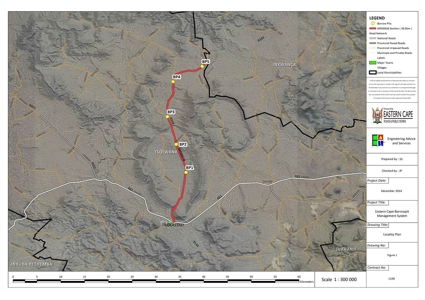
The locations of all the proposed borrow pits and
the road section they are to be used for are shown in figure 1. The affected
roads are situated north of Tarkastad along the MR00638.
Table 3: Locality of proposed
borrow pits.
|
Road
|
BP
|
Coordinates
|
LMA
|
Comment
|
|
DR02581
|
11.1
|
31.91967 S
26.30005 E
|
Tsolwana
|
|
|
|
|
16.7
|
31.87199 S
26.28068 E
|
Tsolwana
|
|
|
|
|
22.4
|
31.82505 S
26.26876 E
|
Tsolwana
|
|
|
|
|
29.8
|
31.74533 S
26.26727 E
|
Tsolwana
|
|
|
|
|
33.4
|
31.73713 S
26.3306 E
|
Tsolwana
|
|
|
A screening of Regional Biodiversity Features was
undertaken, based on a model developed that included the following features:
·
Protected areas
·
World Heritage Sites and their legally proclaimed buffers
·
Critically Endangered and Endangered ecosystems
·
Critical Biodiversity Areas
·
River and wetland Freshwater Ecosystem Priority Areas (FEPAs),
and
·
100 m Buffer of rivers and wetlands
·
RAMSAR Sites
·
Protected area buffers
·
Trans-frontier Conservation Areas (remaining areas outside of
formally proclaimed PAs)
·
High water yield areas
·
Coastal Protection Zone
·
Estuarine functional zones
·
Ecological support areas
·
Vulnerable ecosystems
·
Focus areas for land-based protected area expansion and focus
areas.
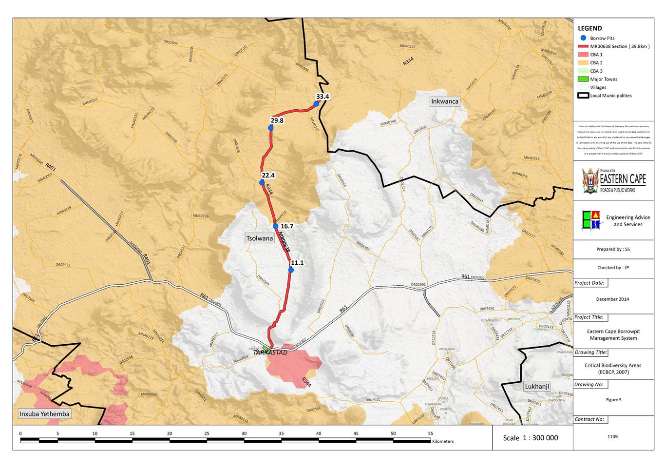
A summary of these features (illustrated in Figure 4 to Figure 6) is provided in Table 4 below.
Table 4: Summary of Biodiversity features for the Borrow Pit sites.
|
Borrow Pit
|
Vegetation Type:
|
Status
|
Present land use:
|
CBA
|
|
11.1
|
Queenstown Thornveld
|
Least Threatened
|
Natural/Grazing
|
|
|
16.7
|
Queenstown Thornveld
|
Least Threatened
|
Natural/Grazing
|
|
|
22.4
|
Queenstown Thornveld
|
Least Threatened
|
Natural/Grazing
|
CBA 2
|
|
29.8
|
Queenstown Thornveld
|
Least Threatened
|
Natural/Grazing
|
CBA 2
|
|
33.4
|
Queenstown Thornveld
|
Least Threatened
|
Natural/Grazing
|
CBA 2
|
The locations of all
the proposed borrow pits and the road sections they are to be used for are
shown in Social and economic
environment
The Borrow Pits will be utilised for routine
maintenance of gravel roads in the area. These roads connect the villages and
urban areas, thus if they are not maintained there will be a negative impact on
the people, their health (safety) and their livelihoods. Furthermore vehicular
‘wear and tear’ results in higher living costs. Formalisation of the Borrow
Pits will allow for regular routine maintenance of the roads that will benefit
not only local communities and residents but also all road users.
No people will be directly affected by the
proposed mining of Borrow Pits, but there may be a temporary noise and dust
increase on nearby residents. Potential Impacts will be assessed on an
individual Borrow Pit basis in the following sections.
There are certain risks posed to human health and safety via
exposure to high noise and dust levels, as well as steep and/or unstable faces
formed during mining activities. Pools of standing water can also pose a risk
to livestock and people in rural areas. Community health and safety risks
should be controlled through the implementation of a Health and Safety
Management Plan to be implemented by the Contractor. Existing unsafe
excavations (with vertical faces) and deep excavations where standing water can
accumulate should be “made safe” on closure using unused and stockpiled
overburden and topsoil.
Figure 1. The
affected roads are situated South-East of Cala and North-West of Engcobo.
Queenstown is located 140 km West of Engcobo and 100
km south-west of Cala (Sakhisizwe).
The surrounding area can generally be described as
flat or gentle undulating lowland plains intersected by moderately rolling
hills and mountains, much incised by river gorges. Drainage of the region is
mainly in a southerly direction.
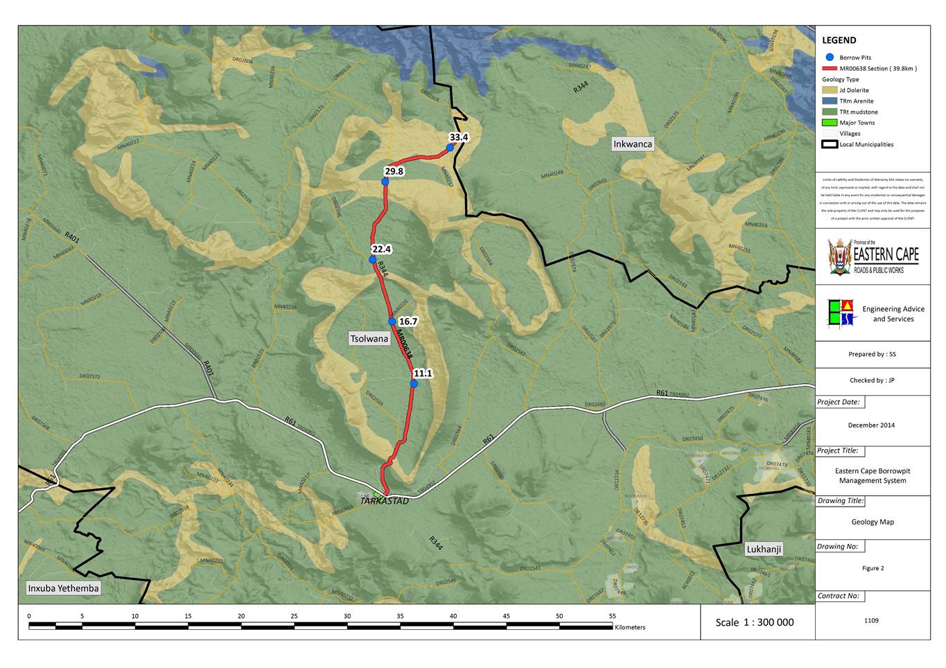
As per the Geological Map in Figure
2, the Geology in the region consists of the following:
|
Symbol
|
Lithology
|
Formation
|
|
Jd
|
Volcanic Rocks, gabbro, pikriet
|
Karroo
sequence, Drakensberg Group
|
|
Jdb
|
Volcanic Rocks, Basaltic Lava,
subordinate tuff and agglomerate
|
Drakensberg Group
|
|
TRm
|
Volcanic Rocks, Basaltic Lava,
subordinate tuff and agglomerate
|
Karroo sequence,
Drakensberg Group, Molteno Formation
|
|
TRb
|
Brownish Red
and grey mudstone, sandstone (Sedimentary)
|
Karroo
sequence, Beaufort Group, Tarkastad subgroup, Burgersdorp Formation
|
|
TRe
|
Brownish-red and grey mudstones,
sandstone
|
Drakensberg Group, Elliot Formation
|
|
Alluvium
|
Alluvium
|
|
The study area is underlain mostly by sedimentary
rocks of the Early Triassic Period Karoo Supergroup, which was formed under
fluvial conditions when the inland Karoo Sea was drying out and wide plains
were being carved by large river systems. These rivers deposited the sands and
muds on broad flood plains which over time became interbedded sandstone and
mudstone of the Katberg and Burgersdorp Formations (both of the Tarkastad
Subgroup, Karoo Supergroup).
The Katberg Formation has been mapped in the
southern and south-western part of the site and is dominated by sandstone
lithologies formed by multi-channelled braided river environments. The braided
river system resulted in the development of a deeply eroded landscape with few
fine-grained (mud and silt) overbank deposits developing. This formation
therefore consists mainly of sandstone with sub-ordinate argillaceous (rock
containing clay) maroon-coloured mudstone.
A return to a meandering river system is reflected
in the mudstone-dominated strata of the Burgersdorp Formation, which has been
mapped in the eastern and north-eastern parts of the study area. This formation
is dominated by maroon, grey and olive-coloured mudstone and is considered a
distal equivalent to that of the Katberg Formation.
These Beaufort Group rocks are interrupted by
doleritic dykes (vertical intrusion) and sills (horizontal intrusion) formed
during the Jurassic Period. These intrusions forced their way between the
sedimentary strata during the eruption phases that formed the Drakensberg Group
basalts. The sedimentary rocks into which the dolerite intruded are often
altered (metamorphosed) in aureoles adjacent to intrusions (e.g. Hornfels). The
dolerite has a regional north-south trend around which the Sabalele Road has
been constructed. This material is, therefore, likely to be intersected in
outcrop in the southern part of the study area.
Geotechnical Interpretation
The Karoo Supergroup rocks generally reveal a
subdued topography in the study area with a variable weathering profile. The
sandstone lithologies tend to be more weathering resistant and are blanketed by
a thinner soil cover than that of the softer, mudstone rocks. The completely
weathered rock/ residual soil interface is commonly susceptible to dispersion
and piping erosion, resulting in the development of the characteristic
donga-marked landscape where sloping ground prevails.
The sandstone lithologies have a rock strength
that is often considered too low for use as base course or sub base, yet it is
too high (and has little binding capabilities) for use as a crushed wearing
course on unsurfaced roads. This material is likely to require crushing for any
aggregate application. The mudstone rocks also have a rock strength that is
considered too low for use as base course or sub base. The rock is, however,
often a preferred material for gravel wearing course applications, and breaks
down easily on the roadway during mechanical placement. Most of the Karoo
Supergroup rocks are considered suitable for select subgrade applications.
The intrusive dolerites can be highly variable in
terms of rock strengths and weathering profiles. The geotechnical properties of
these rocks are often affected by the cooling rates of the magma when they were
formed; slow cooling magma forms larger crystals that develop into high
strength rocks, whilst quickly cooling magma forms smaller crystals that can
eventuate into low strength rocks. The dolerite also displays a weathering
profile that can be deep (tens of metres) and dominated by fresh rock core
stones of variable sizes, or shallow weathering with soil cover often less than
one metre underlain by competent rock without core stones. The weathering
profiles and rock strengths of dolerite are not easily ascertainable based on
surface outcrop. It is common, nevertheless, for the dolerite outcrop to reveal
a positively weathered landform in the study area, frequently associated with a
very different vegetation cover to that of the surrounding Karoo Supergroup
rocks.
The extremely weathered dolerite reveals a deep
red-coloured soil cover often pock-marked with sub-rounded and well-rounded
dolerite core stones. These weathered soils are often highly dispersive and
erosion scours are common in areas where positive relief is not offered adequate
protection from vegetation cover. Doleritic soil is frequently highly expansive
and considered unsuitable for any road construction application. The materials’
construction suitability improves with depth as the highly weathered rock
(Sabunga) is considered suitable for gravel wearing course use in arid
environments, whilst the moderately weathered, slightly weathered and fresh
rock is a well-documented source of good sub base and base course.
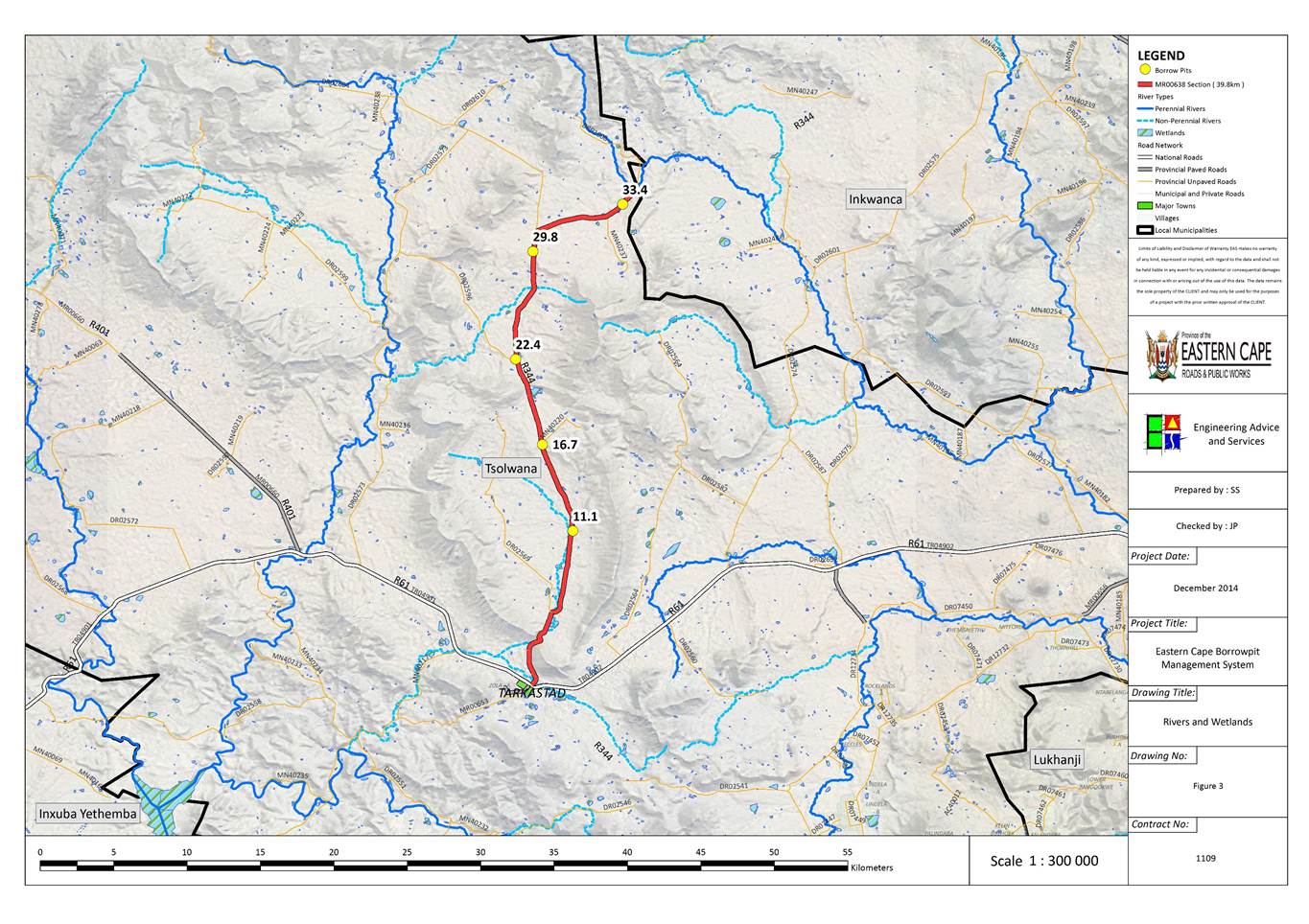
The drainage of the area generally flows in a south-easterly
direction (Figure 3). The Klaas Smits and Swart Kei Rivers are the main
drainage systems. The minor seasonal streams in the surrounding area in
proximity to the Borrow Pits are tributaries of these rivers. Where Borrow
Pits are in the vicinity of drainage lines and rivers, stormwater and runoff
will need to be adequately managed to prevent increased turbidity of downstream
river systems. With the proper implementation of the EMP it likely that any
existing impacts that are currently present will be reduced. Rivers area
indicated on the close-up maps of the individual Borrow Pit descriptions.
Some wetlands (Natural and artificial) may be in
proximity to seasonal wetlands. As for drainage lines above, runoff will need
to be managed and will be dealt with in Borrow Pit descriptions accordingly.
After rehabilitation of the Borrow Pits, some areas will probably be natural
accumulation areas for runoff from surrounding areas and become small dams or
artificial wetlands in the long-term.
Groundwater resources could potentially be
affected by the mining of Borrow pits due to inadvertent fuel and chemical
spills. If the management measure prescribed below are adhered to it is not
anticipated that groundwater resources would be significantly affected by the
Borrow Pits.
The area is a predominantly summer rainfall area.
The mean annual rainfall for Encobo (809.9
mm), decreasing westwards. Mean annual temperatures in the Engcobo area is 16.7°C
Air quality levels in rural areas surrounding the
Borrow Pit sites are typically good. The gravel roads are however a source of
dust, especially during dry windy conditions. Air quality may be temporarily
affected by the mining and concomitant road surfacing operations during the
routine maintenance periods.
The Borrow pit sites are generally situated
relatively close to provincial gravel roads, which are an existing source of
noise. The current ambient noise levels are assumed to be relatively high due
to road traffic. Noise receptors during mining operations would typically be
residents in the villages nearest to the sites.
The Beaufort Group is Late Permian (255 million
years) to Mid Triassic (237 million years) in age. Characteristic fossils
include fish, amphibians and reptiles with a dominance of mammal-like reptiles
(Theraptids). In addition, characteristic fossils include plant fossils of the
Glossopteris flora with occasional invertebrate fossils (freshwater
bivalve molluscs). Most of the fossil specimens represent groups that are now
extinct. It is estimated that less than 5 % of sites have been identified in
the Eastern Cape. There is a lack of identified sites in the District.
An internationally important record of life during
the early diversification of land vertebrate is provided by the floodplain of
the Beaufort Group (Karoo Supergroup). Giant amphibian coexisted with diapsid
reptiles (the ancestors of dinosaurs, birds and most modern reptiles), anapsids
(which probably include the ancestors of tortoises) and synapsids, the dominant
of the group of the time which included the diverse therapsids (including the
ancestors of mammals). The rocks provide the world’s most complete record of
the important transition from early reptiles to mammals.
Most plant and animals were decimated during the
end-Permian extinction event with Therapsid diversity being a serious contender
for the most severe extinction event to affect life on Earth. Ongoing research
on the effects of this extinction event is facilitated by the detailed record
(afforded by the Beaufort Group strata) of life immediately before and after
the event, as well as the gradual recovery of life afterwards.
The Beaufort Group is subdivided into a series of
biostratigraphic units on the basis of its faunal content. There is a marked
faunal change that occurs between the Dicynodon and Lystrosaurus
Assemblage Zones and approaches the tops of the Balfour Formation. This
corresponds with the major extinction event associated with the Perno-triassic
boundary. The Lustrosaurus Assemblage Zone spans the uppermost
(Palingkloof) member of the Balfour Formation, the Katberg Formation (Tarkastad
Subgroup, Beaufort Group, Karoo Supergroup) and the lower part of the
Burgersdorp Formation (Tarkastad Subgroup, Beaufort Group, Karoo Supergroup).
The Lystrosaurus Assemblage Zone is
dominated by a single genus of dicynodont, Lyystrosaurus, which together
with the captorhinid reptile (Procolophon) characterise this zone. Biarmosuchian
and gorgonopsian Therapside do not survive into the Lystrosaurus
Assemblage Zone, though therocephalian and cyndontian Therapside exhibit
moderate abundance. Captohinid Reptilia are reduced, however, an unprecedented
diversity of giant amphibian characterises this interval.
The effect of the end Permian extinction event are
also evident in the extensive and important record of fossil plants present in
the rocks of the Karoo. Whereas faunas of the Pemian age are dominated by a
wide range of early seed plants, the Glossopteridale (which probably include
the ancestors of modern gymnosperms and ultimately angiosperms), this group
appears to have gone entirely extict during the end-Permian extinction. The
rocks of the Karoo provide an unrivalled sequential record of these change and
the diversification of other group of plants in the aftermath of the
extinction. The strata of the Karoo basin have also yielded fossils insects and
insect leaf damage of a range of ages.
Though including the uppermost level of the Lystrosaurus
Assemblage Zone, the Burgersdorp Formation largely corresponds to the Cynognathus
Assemblage Zone. Synapsid therapsid diversity does not demonstrate recovery
between the Lystrosaurus and Cynognathus assemblage zones. The Dicynodontia,
Lystrosaurus and Myosaurus are replance by Kombuisia and the
giant Kannemeyeria. Therocephalia exhibit a turnover of taxa at a
generic level, but an overall reduction in diversity. Cynodontia (Therapsida,
Synasida) alone amongst synapsids demonstrate a slight increase in genera.
These include the small advance Cynodont, Cynognathus, which together
with the Cynodont Diademodon and the Dicynodont Kannemeyeria, characterise
this assemblage zone. Eosuchid and captorhinid Reptilia are moderately common,
though showing no generic continuity with taxa of the underlying zone. Amphibia
remain diverse, though they are not as generically diverse as in the Lystosaurus
Assemblage Zone and likewise demonstrate no genus level continuity therewith.
Fossil fish reach their greatest known Karoo Supergroup diversity in the
Burgersdorp Formation (Cynognathus Assemblage Zone). Plants (Dadoxylon,
Dicroidium and Schizoneura), trace fossils (including both
vertebrate and invertebrate burrows) and a freshwater bivalve (Unio
karooensis) have also been recovered.
As Dolerite is an intrusive igneous rock, it
contains no fossils.
Archaeological remains can consist of the following:
1.
Human remains (graves, informal graves and cemeteries)
2.
Stone artefacts and tools
3.
Large Stone Features (Isisivane and circular stone walls)
4.
Freshwater shell middens
5.
Historical artefacts and features
6.
Fossil Bone
1 Human Remains
Any, and all, human remains that
are exposed during all phases of construction must be reported to the
archaeologist, nearest museum or relevant heritage resources authority.
Construction must then be halted until the archaeologist has investigated and
removed the human remains. Human remains may be exposed when a grace or
informal burial has been disturbed. Remains are either buried in a flexed
position on the side, or in a sitting position with a flat stone capping the
location of the burial. Developer are requested to be aware of the exposing
human remains.
2 Stone Artefacts
Stone artefacts can be difficult
for the layman to identify. Large accumulations of flaked stones that do not
appear to have been distributed naturally must be reported. If the stone
artefacts are associated with bone / faunal remains or any other associated
organic and material cultural artefacts, development must be halted immediately
and reported to the archaeologist, nearest museum or relevant heritage
resources authority.
3 Large Stone Features
Even though large stone features
occur in different forms and sizes, they are relatively easy to identify. The
most common features are roughly circular walls (most collapsed), usually dry
packed stone, and may represent: stock enclosures, the remains of wind breaks or
cooking shelters. Other features consist of large piles of stones of different
sizes and height that are known as isisivane. These features generally
occur near river and mountain crossings. The purpose and meaning of the isisivane
are not fully understood, however, interpretations include the representation
of burial cairns and symbolic value.
4 Freshwater Shell Middens
Accumulations of freshwater shell
middens comprising mainly freshwater mussel occur along the muddy banks of
rivers and streams and were collected by pre-colonial communities as a food
resource. The freshwater shell middens generally contain; stone artefacts,
pottery, bone and (sometimes) human remains. Freshwater shell middens may be of
various sizes and depths. An accumulation that exceeds 1
m² in extent must be report to the archaeologist, nearest museum or relevant
heritage resources authority.
5 Historical Artefact and Features
These are relatively easy to
identify and include the foundations and remain of buildings, packed dry stone
walling representing domestic stock kraals. Other items include historical
domestic artefacts such as: ceramics, glass, metal and military artefacts and
dwellings.
6 Fossil Bones
Fossil bones may be embedded in
geological deposits. Any concentrations of bone (whether fossilized of not)
must be reported to the archaeologist, nearest museum or relevant heritage
resources authority.
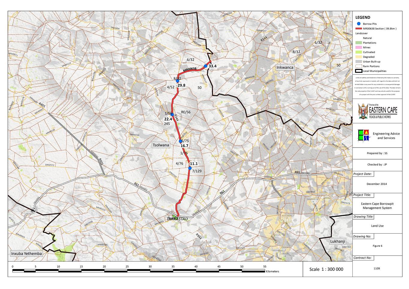
As indicated in Figure
6 the Borrow Pits are predominantly located within or adjacent to areas
classified as Degraded, Cultivated and in some cases (Peri) Urban as per the
SANBI Land Cover (2009) map.
The erosion potential of soils is the sensitivity
of soils to the effects of wind and water on the soil structure. The
erodability index is determined by combining the effects of slope and soil
type, rainfall intensity and land use. A low value indicates a high erosion
risk and a high value indicates a low erosion risk. The area falls within an
erodability index of between 7 and 9, indicating that the area has a moderate
to high susceptibility to erosion. Adequate measures must thus be implemented
to minimise erosion.
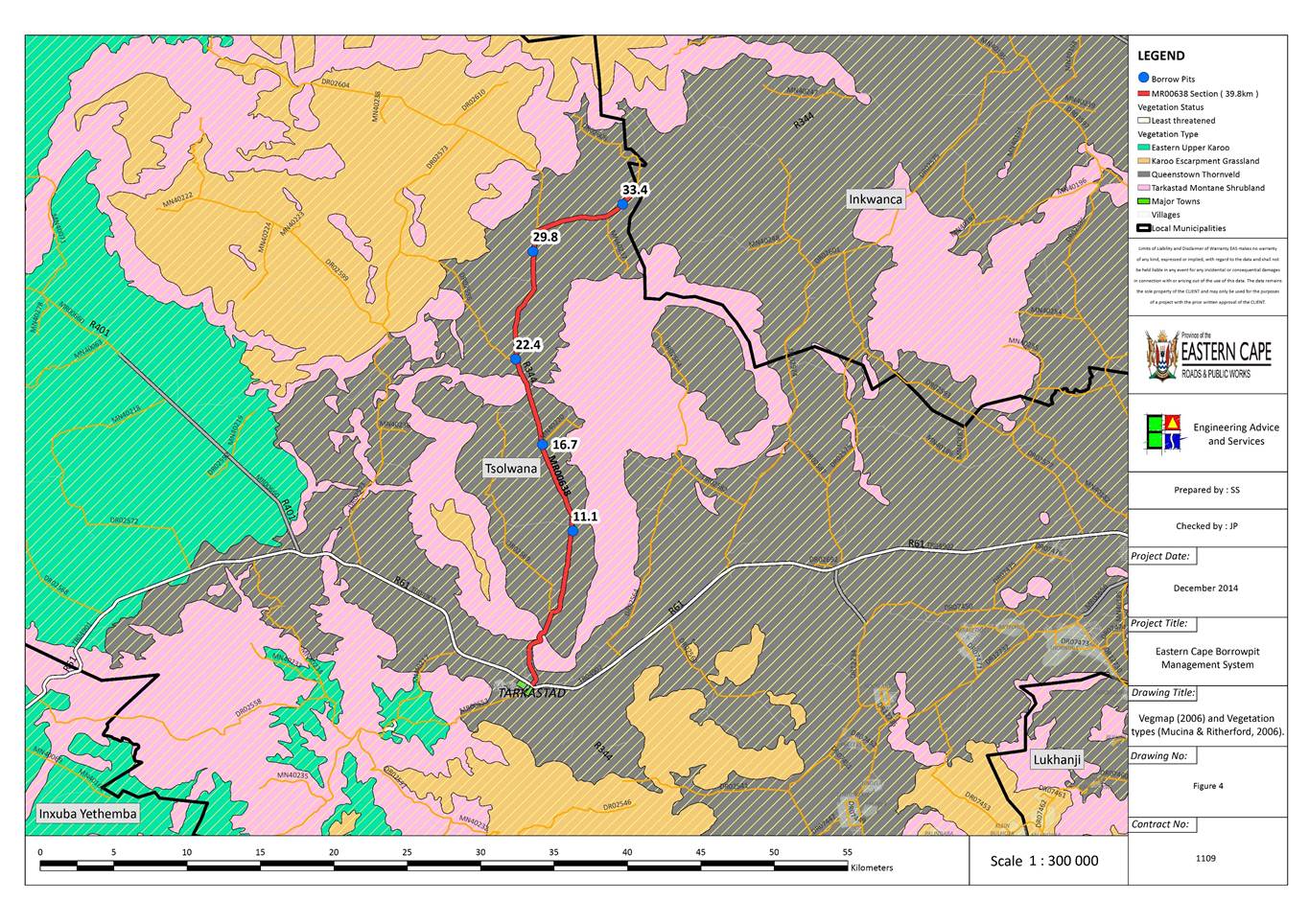
At a regional level, a single vegetation types are
recognised within the immediate vicinity of the borrow pit sites (Mucina & Rutherford, 2006), which is namely Queenstown Thornveld (Figure
4), having a conservation status of Least Threatened (Mucina
& Rutherford, 2006).
Queenstown Thornveld
Distribution ranges within the Eastern Cape from
Tarkastad to Queenstown. Typical species include: Acacia karroo thornveld
dominated by Aristida congesta, Cymbopogon pospischilii, Eragrostis curvula
and Tragus koelerioides grasses, with scattered shrubs in places.
Present on flat bottomlands of intramontane basis
with adjacent slopes. Rainfall is typically in late summer (peak in Feb –
March) with MAP 280 – 720 mm p.a.
The geology is dominated by sedimentary rocks of
the Tarkastad Subgroup (Beaufort Group, Karoo Supergroup), overlain with
clay-loam soils typical of the Da and Fc land types.
Conservation: Least threatened. Target 23 %.
Around 1 % statutorily conserved in the Tsolwana Nature Reserve. About 10 %
is transformed with overgrazing and urban expansion important factors.
2.6.12 Eastern Cape
Biodiversity Conservation Plan (ECBCP)
Critical biodiversity areas (CBAs) are terrestrial
and aquatic features in the landscape that are critical for conserving
biodiversity and maintaining ecosystem functioning (SANBI 2007). These form the
key output of the conservation plan. They are used to guide protected area
selection and should remain in their natural state as far as possible.
As indicated in Figure
5, the Eastern Cape Biodiversity Conservation Plan (ECBCP, 2007) the Borrow
Pits are situated in areas designated a CBA 2 or no status (terrestrial). Due
to the limited size of these Borrow Pits, their effect on Critical Biodiversity
Areas will be minimal. Individual Borrow Pits that are within CBA 2 areas
will be highlighted and appropriate measures recommended in the Impact and
Mitigation sections of the report where specific measures are necessary.
No Borrow Pits are located within designated
Reserves (class 1 and class 2) none are within aquatic CBA’s.
The expansion of the borrow pits is unlikely to compromise
the vegetation units significantly due to:
·
The small mining footprint.
·
The generally degraded state of the existing borrow pits and
immediate vicinity.
·
The general close proximity to the road reserves.
·
The implementation of a formalized rehabilitation plan.
Loss of vegetation cover will thus tend to be
highly localised and have a minimal impact (individual and cumulative) at a
regional level. Furthermore it will most likely result in an overall
improvement of the ecological integrity of existing sites that currently tend
to be in a highly degraded state, as a result of inadequate historical
remediation methods.
The impact of the expansion of existing Borrow
Pits, generally located directly adjacent to roads in areas that are generally
degraded is unlikely to have any significant negative impact on ecological
processes occurring at a regional level. The implementation of best practice
guidelines (as per the EMP) will most likely be effective management to
minimise any negative consequences to being located within Critical Biodiversity
Areas. In addition, since the existing Borrow Pits are currently inadequately
managed, the implementation of the recommended management actions in the EMP
will most likely result in an improvement to the status quo.
Any Borrow Pits that are significantly affected by
the Regional Planning Frameworks will be dealt with accordingly in their
relative Impact and Mitigation sections.
Based on a desktop Assessment of existing online
databases as well as field verification, the potential list of flora and fauna
species that may occur in the vicinity of the Borrow Pits, is quite extensive.
Common flora species such as: Aloe arborescens, Aloe ferox, Aloe maculata,
Bulbine abyssinica and Boophone disticha, are common around some of
the sites.
The Giant Bull Frog, may be present in wetlands,
but are unlikely to be affected by the Borrow Pits, which will not likely
impact on any wetlands.
Appendix E provides a detailed list of species
protected in term of the P.N.C.O., for which permits may be required should
they occur. However limited field assessments indicate that the majority of
these species are unlikely to be present. Due to limited sampling time, Presence
or absence cannot be confirmed without detailed seasonal site visits, but the
risk of any Critically Endangered or Endangered species being present is Low.
The limited expansion of the Borrow Pits is thus unlikely to result in any
significant impact to species conservation.
No Red Listed Critically Endangered or Endangered
species are recorded for the area.
Table 5: Species of Special Concern known to
occur in the vicinity of the sites.
|
Scientific Name
|
Family
|
Common name
|
Status
|
Endemic
|
|
Flora
|
|
Albuca setosa
|
HYACINTHACEAE
|
|
PNCO
|
|
|
Aloe arborescens
|
ASPHODELACEAE
|
|
PNCO
|
|
|
Aloe ferox
|
ASPHODELACEAE
|
|
PNCO
|
|
|
Aloe maculata
|
ASPHODELACEAE
|
|
PNCO
|
|
|
Aristea anceps
|
IRIDACEAE
|
|
PNCO
|
|
|
Bergeranthus multiceps
|
MESEMBRYANTHEMACEAE
|
|
PNCO
|
|
|
Boophone disticha
|
AMARYLLIDACEAE
|
|
PNCO
|
|
|
Brunsvigia grandiflora
|
AMARYLLIDACEAE
|
|
PNCO
|
|
|
Bulbine abyssinica
|
ASPHODELACEAE
|
|
PNCO
|
|
|
Bulbine asphodeloides
|
ASPHODELACEAE
|
|
PNCO
|
|
|
Bulbine narcissifolia
|
ASPHODELACEAE
|
|
PNCO
|
|
|
Cyrtanthus macowanii
|
AMARYLLIDACEAE
|
|
PNCO
|
|
|
Delosperma repens
|
MESEMBRYANTHEMACEAE
|
|
PNCO
|
|
|
Dierama atrum
|
IRIDACEAE
|
|
PNCO
|
|
|
Dietes iridioides
|
IRIDACEAE
|
|
PNCO
|
|
|
Drimia macrocentra
|
HYACINTHACEAE
|
|
PNCO
|
|
|
Eulophia foliosa
|
ORCHIDACEAE
|
|
PNCO
|
|
|
Gasteria excelsa
|
ASPHODELACEAE
|
|
PNCO
|
|
|
Gladiolus longicollis subsp. longicollis
|
IRIDACEAE
|
|
PNCO
|
|
|
Gladiolus mortonius
|
IRIDACEAE
|
|
PNCO
|
|
|
Haemanthus humilis subsp. humilis
|
AMARYLLIDACEAE
|
|
PNCO
|
|
|
Holothrix scopularia
|
ORCHIDACEAE
|
|
PNCO
|
|
|
Hypoxis acuminata
|
HYPOXIDACEAE
|
|
PNCO
|
|
|
Hypoxis angustifolia var. buchananii
|
HYPOXIDACEAE
|
|
PNCO
|
|
|
Ledebouria cooperi
|
HYACINTHACEAE
|
|
PNCO
|
|
|
Ledebouria revoluta
|
HYACINTHACEAE
|
|
PNCO
|
|
|
Ornithogalum longibracteatum
|
HYACINTHACEAE
|
|
PNCO
|
|
|
Ornithogalum tenuifolium subsp.
tenuifolium
|
HYACINTHACEAE
|
|
PNCO
|
|
|
Ruschia putterillii
|
MESEMBRYANTHEMACEAE
|
|
PNCO
|
|
|
Satyrium longicauda var. longicauda
|
ORCHIDACEAE
|
|
PNCO
|
|
|
Satyrium parviflorum
|
ORCHIDACEAE
|
|
PNCO
|
|
|
Watsonia densiflora
|
IRIDACEAE
|
|
PNCO
|
|
|
Watsonia pillansii
|
IRIDACEAE
|
|
PNCO
|
|
|
Mammals
|
|
Myotis tricolor
|
VESPERTILIONIDAE
|
Temminck's Hairy Bat
|
Near Threatened
|
|
|
Reptiles
|
|
None
|
|
|
|
|
|
Amphibians
|
|
Pyxicephalus adspersus
|
PYXICEPHALIDAE
|
Giant Bull Frog
|
NT
|
|
|
Invertebrates
|
|
Aslauga australis
(Butterfly)
|
LYCAENIDAE
|
Southern Purple
|
Data Deficient
|
Yes
|
|
Chrysoritis lyncurium
(Butterfly)
|
LYCAENIDAE
|
Tsomo River Opal
|
Vulnerable
|
Yes
|
|
Chrysoritis penningtoni
(Butterfly)
|
LYCAENIDAE
|
Pennington's Opal
|
Vulnerable
|
Yes
|
|
Fish
|
|
Clarias gariepinus
|
CLARIIDAE
|
|
NEMBA (NL)
|
|
The plant and animal species of special concern
listed above require permits if any individuals are to be removed, translocated
or pruned according to the relevant legislation including the National Forests
Act and the Provincial Nature Conservation Ordinance as well as Threatened and
Protected Species (T.o.P.S.)
The Borrow Pits will be utilised for routine maintenance
of gravel roads in the area. These roads connect the villages and urban areas,
thus if they are not maintained there will be a negative impact on the people,
their health (safety) and their livelihoods. Furthermore vehicular ‘wear and
tear’ results in higher living costs. Formalisation of the Borrow Pits will
allow for regular routine maintenance of the roads that will benefit not only
local communities and residents but also all road users.
No people will be directly affected by the
proposed mining of Borrow Pits, but there may be a temporary noise and dust
increase on nearby residents. Potential Impacts will be assessed on an
individual Borrow Pit basis in the following sections.
There are certain risks posed to human health and safety via
exposure to high noise and dust levels, as well as steep and/or unstable faces
formed during mining activities. Pools of standing water can also pose a risk
to livestock and people in rural areas. Community health and safety risks should
be controlled through the implementation of a Health and Safety Management Plan
to be implemented by the Contractor. Existing unsafe excavations (with
vertical faces) and deep excavations where standing water can accumulate should
be “made safe” on closure using unused and stockpiled overburden and topsoil.
Figure 1:
Map indicating locality of borrow pits with major roads, towns, etc.
Figure 2: Geology Map.
Figure 3: Rivers and Wetlands
Figure 4: Positioning of the Borrow Pits relative to
the Vegmap (2006) vegetation types (Mucina & Rutherford, 2006).
Figure 5: Critical Biodiversity Areas, as per Eastern Cape
Biodiversity Conservation Plan (ECBCP, 2007). CBA 1, 2 & 3 areas as well
as Forest pockets and Expert species data are shown.
Figure
6: Land Use – excluding Natural Vegetation (SANBI Landcover, 2006)
indicating Plantations, Degraded, Cultivated and Urban/Per-Urban areas.