Environmental
Management Plan for Proposed Borrow Pits, Intsika Yethu, Sakhisizwe &
Engcobo Local Municipalities, Eastern Cape
Submitted
in terms of Section 39 and of Regulation 52 of the Mineral and Petroleum
Resources Development Act, 2002 (Act 28 of 2002)
Report Prepared by:
Engineering Advice & Services
(Pty) Ltd
EAS
Project Number: 1105 (Volume 1)
DMR
Contract Number:
Report Prepared for:

Eastern Cape Department of Roads and
Public Works
22 August 2014
Proposed Borrow Pits Engcobo Local Municipalities, Eastern
Cape
For:
Eastern Cape Department of Roads and Public Works
Private Bag
X0022, Bhisho, 5605
By: Engineering
Advice & Services (Pty) Ltd.
73 Heugh Road, Walmer, Port Elizabeth
6013
Tel: +27 (0) 41 581 2421
Fax: +27 (0) 86 683 9899
EAS
Project Number: 1105 (Volume 1)
DMR
Contract Number:
22
August 2014
Compiled by:
|
Name
|
Company
|
Email
|
|
Mr Jamie Pote
|
Engineering Advice & Services
(Biophysical and EMP)
|
jamiep@easpe.co.za
|
|
Mr Dieter Bester
|
Engineering Advice & Services
(Geotech and Engineering)
|
dieterb@easpe.co.za
|
|
Mr Mark Rynhoud
|
Engineering Advice & Services
(Geology)
|
markr@easpe.co.za
|
|
Mr Ray Parker
|
Engineering Advice & Services
(Engineering and Review)
|
ray@easpe.co.za
|
Executive
Summary
The Eastern Cape
Department of Roads and Public works (DRPW) require material for general
maintenance of provincial roads, in particular gravel roads. There are
numerous existing borrow pits (BP’s) hat have been historically used to
maintain these roads, however these are not formally registered with the
Department of Mineral Resources (DMR).
EAS was appointed
as the independent consultants to assess the environmental impacts and
requirements in terms of the Mineral and Petroleum Resources Development Act
(MPRDA, Act 28 of 2002).
The specific roads in
the Intsika Yethu, Sakhisizwe & Engcobo Local Municipal Areas are the DR08248,
DR08247, DR08041 & DR 8504 roads, 15 borrow pits were selected subject to
criteria including material type, location, access, surrounding land use,
slope, erosion, hydrology and sensitive vegetation. Three sites were selected
along the DR08248, 5 along the DR08247, 6 along the DR08041 & 1 along the
DR 8504 roads. The borrow pits will be used exclusively for the
upgrade/re-gravelling of the road they are situated adjacent to.
This report serves
as an application for a mining right for these 15 borrow pits to the DMR and is
prepared in accordance with the requirements of the MPRDA and DMR.
Table of
Contents
Executive Summary. ii
Table of Contents. iii
List of Figures. vi
List of Tables. vi
Abbreviations. vii
Glossary. viii
Release Notes. x
1 Introduction &
Overview.. 1-1
1.1 Legal and Administrative Requirements. 1-1
1.1.1 MPRDA Section 106 (1). 1-1
1.2 NEMA principles of
particular relevance to biodiversity: 1-5
1.3 Responsibilities of Role
Players. 1-5
1.3.1 Developer. 1-5
1.3.2 Consulting Engineer. 1-5
1.3.3 Contractor. 1-6
1.3.4 Environmental Control
Officer. 1-6
1.3.5 Environmental Liaison
Officer. 1-6
1.4 Approach. 1-6
1.5 Limitations. 1-7
1.6 Applicant and Consultant
Details. 1-7
1.7 Report Structure. 1-8
2 Proposed Project Description. 2-11
2.1 Motivation. 2-11
2.2 Activity Description. 2-11
2.3 Activity Location. 2-11
2.4 Borrow Pit Locations. 2-11
2.5 Description of the
Existing Environment. 2-12
2.5.1 Introduction. 2-12
2.5.2 Site Locality. 2-13
2.5.3 Topography. 2-13
2.5.4 Geology and soils. 2-14
2.5.5 Hydrology (Ground and
surface water). 2-15
2.5.6 Climate. 2-15
2.5.7 Air quality. 2-16
2.5.8 Noise. 2-16
2.5.1 Paleontological resources. 2-16
2.5.2 Archaeological resources. 2-17
2.5.3 Land Use. 2-18
2.5.4 Erosion Potential 2-18
2.5.5 Vegetation of Southern
Africa. 2-18
2.5.6 Eastern Cape Biodiversity
Conservation Plan (ECBCP). 2-20
2.5.7 Implications of Regional Planning
frameworks. 2-20
2.5.8 Species of Special
Concern occurring in the region. 2-21
2.5.9 Social and economic
environment. 2-22
2.5.10 Health and Safety. 2-23
2.6 List of Maps. 2-23
3 Individual Borrow Pit Assessments. 3-30
3.1 Borrow Pit DR08041/5.9. 3-31
3.2 Borrow Pit DR08041/14.4. 3-37
3.3 Borrow Pit DR08041/28.8. 3-43
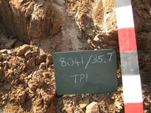
3.4 Borrow Pit DR08041/35.7. 3-49
3.5 Borrow Pit DR08041/37.7. 3-55
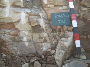
3.6 Borrow Pit DR08041/50.1. 3-61
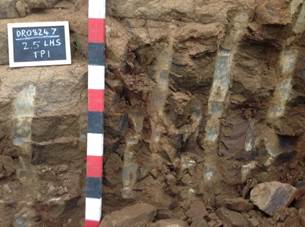
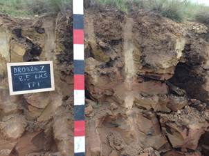
3.7 Borrow Pit DR08247/2.5. 3-67
3.8 Borrow Pit DR08247/8.5. 3-73
3.9 Borrow Pit DR08247/19.1. 3-79
3.10 Borrow Pit DR08247/23.2. 3-85
3.11 Borrow Pit DR08247/Village. 3-91
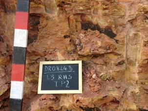
3.12 Borrow Pit DR08248/1.3. 3-97
3.13 Borrow Pit DR08248/11.2. 3-103
3.14 Borrow Pit DR08248/18.0. 3-109
3.15 Borrow Pit DR08504/6.8. 3-115
4 Summary of the potential impacts, significance assessment and the
proposed mitigation measures 4-1
4.1 Assessment of the significance of the potential impacts. 4-1
4.1.1 Criteria of assigning significance to potential impacts. 4-1
4.2 Identification of potential
impacts. 4-2
4.2.1 Possible impacts on
biodiversity during mining construction and operations. 4-2
4.2.2 Actions, activities, or
processes that have sufficiently significant impacts to require mitigation. 4-2
4.2.3 Concomitant list of
appropriate technical or management options. 4-4
4.2.4 Review the significance
of the identified impacts. 4-4
4.2.5 Listed activities (in
terms of the NEMA EIA regulations). 4-5
4.2.6 Potential cumulative
impacts. 4-5
4.2.7 Potential impact on
heritage resources. 4-5
4.2.8 Potential impacts on
communities, individuals or competing land uses in close proximity. 4-5
4.2.9 Confirmation that the
list of potential impacts has been compiled with the participation of the
landowner and interested and affected parties. 4-6
4.2.10 Confirmation of specialist
report appended. 4-6
5 Closure and environmental objectives. 5-1
5.1 Monitoring and Performance. 5-2
6 Financial provision. 6-6
6.1 Undertaking to provide financial provision. 6-6
7 REGULATION 52 (2) (h)
Undertaking to execute the Environmental Management Plan. 7-1
8 Record of the public
participation and the results thereof. 8-1
8.1 Identification of interested and affected parties. 8-1
8.1.1 The details of the
engagement process. 8-1
8.1.2 Description of the
information provided to the community, landowners, and interested and affected
parties 8-1
8.1.3 List of views raised by
consulted parties regarding the existing cultural, socio-economic or
biophysical environment. 8-1
8.1.4 List of views raised by
consulted parties on how their existing cultural, socio-economic or biophysical
environment potentially will be impacted on by the proposed prospecting or
mining operation. 8-1
8.1.5 Other concerns raised by
the aforesaid parties. 8-2
8.1.6 Confirmation that minutes
and records of the consultations are appended. 8-2
8.1.7 Information regarding
objections received. 8-2
8.2 The manner in which the issues raised were addressed. 8-2
9 Environmental awareness plan. 9-1
9.1 Employee communication
process. 9-1
9.2 Description of solutions
to risks. 9-1
9.3 Environmental awareness
training. 9-1
10 Appendices. 10-4
10.1 Appendix A: Environmental Management Plan. 10-5
10.1.1 General Requirements. 10-5
10.1.2 Biodiversity Requirements. 10-7
10.1.3 Historical, Archaeological
and Paleontological Sites. 10-8
10.1.4 Visual Aspects. 10-9
10.1.5 Noise. 10-10
10.1.6 Dust. 10-10
10.1.7 Waste Management and
Ablution Facilities. 10-10
10.1.8 Infrastructural Requirements. 10-11
10.1.9 Final Rehabilitation. 10-16
10.1.10 Monitoring and Reporting. 10-18
10.1.11 Training. 10-19
10.1.12 Environmental Incidents. 10-19
10.1.13 Closure objectives and
their extent of alignment to the pre-mining environment. 10-19
10.2 LIST OF FINES. 10-21
10.3 Environmental Management
Programme (EMP) Contract between DRPW and Contractor. 10-22
10.4 Method Statement Control
Sheet. 10-1
10.5 Appendix B: Detailed Impact
Assessment. 10-2
10.6 Appendix C: Potential
Species List. 10-5
10.6.1 Flora. 10-5
10.6.2 Fauna. 10-8
10.7 Appendix D: References. 10-10
10.8 Appendix E: Interested and
Affected Party Correspondence. 10-13
10.9 Appendix F: Borrow Pit
Geological Test Results. 10-15
List of
Figures
Figure 1: Map indicating
locality of borrow pits with major roads, towns, etc. 2-23
Figure 2: Geology Map. 2-23
Figure 3: Rivers and Wetlands. 2-23
Figure 4: Positioning of the Borrow Pits relative to the VEGMAP
vegetation types (Mucina & Rutherford, 2006). 2-23
Figure 5: Critical Biodiversity Areas, as per Eastern Cape
Biodiversity Conservation Plan (ECBCP, 2007). 2-23
Figure 6: Land Use – excluding Natural Vegetation (SANBI Landcover,
2006). 2-23
List of
Tables
Table 1: Details of
Applicant. 1-7
Table 2: Details of Consultant. 1-7
Table 3: Locality of proposed borrow pits. 2-11
Table 4: Summary of Biodiversity features for the Borrow Pit sites. 2-13
Table 5: Species of Special Concern known to occur in the vicinity
of the sites. 2-21
Table 6: List of potential Impacts relating to the expansion of
Borrow Pits. 4-3
Table 7: List of activities having Moderate or higher Significance
AFTER mitigation. 4-4
Table 8: Summary of potential impacts or heritage resources. 4-5
Table 9: Summary of potential impacts on communities. 4-5
Table 10: Summary indicating significance of potential impacts
relating to mining activities (SB = Significance BEFORE Mitigation; SA =
Significance AFTER Mitigation). 4-1
Table 11: Listed Activities associated with Borrow Pits. 4-1
Table 12: List of which parties identified in 7.1 above that were in
fact consulted, and which were not consulted. 8-1
Table 13: Summary table (refer to letters in Appendices). 8-1
Table 14: Detailed Summary of overall Impact Assessment of all
Borrow Pits. 10-3
Abbreviations
|
ASAPA
|
Association of South African Professional
Archaeologists
|
|
BP
|
Borrow Pit
|
|
CARA
|
Conservation of Agricultural Resources Act 43 of
1983
|
|
CBA
|
Critical Biodiversity Area
|
|
CRM
|
Cultural Resource Management
|
|
DEA
|
Department of Environmental Affairs (National)
|
|
DEDEAT
|
Department of Economic Development,
Environmental Affairs and Tourism
|
|
DEMC
|
Desired Ecological Management Class
|
|
DMR
|
Department of Mineral Resources
|
|
DWA
|
Department of Water Affairs
|
|
DWAF
|
Department of Water Affairs and Forestry (former
department name)
|
|
EA
|
Environmental Authorisation
|
|
ECO
|
Environmental Control Officer
|
|
EIA
|
Environmental Impact Assessment
|
|
EIR
|
Environmental Impact Report
|
|
EIS
|
Ecological Importance and Sensitivity
Classification
|
|
EMC
|
Ecological Management Class
|
|
EMP
|
Environmental Management Plan
|
|
EMPr
|
Environmental Management Programme report
|
|
ER
|
Environmental Representative
|
|
ESS
|
Ecosystem Services
|
|
IAP’s
|
Interested and Affected Parties
|
|
IEM
|
Integrated Environmental Management
|
|
LHS
|
Left Hand Side
|
|
LM
|
Local Municipality
|
|
LoM
|
Life of Mine
|
|
masl
|
meters above sea level
|
|
MIA
|
Mining Infrastructure Area
|
|
MPRDA
|
Mineral and Petroleum Resources Development Act
28 of 2002
|
|
NBA
|
National Biodiversity Assessment
|
|
NEMA
|
National Environmental Management Act 107 of
1998
|
|
NEMBA
|
National Environmental Management: Biodiversity
Act 10 of 2004
|
|
NFA
|
National Forest Act 84 of 1998
|
|
NOMR
|
New Order Mining Right
|
|
PEMC
|
Present Ecological Management Class
|
|
PES
|
Present Ecological State
|
|
RDL
|
Red Data List
|
|
RHS
|
Right Hand Side
|
|
RoD
|
Record of Decision
|
|
RoM
|
Run of Mine
|
|
SAHRA
|
South African Heritage Resources Agency
|
|
SANBI
|
South African Biodiversity Institute
|
|
SARTM
|
South African Rural Traffic Model
|
|
SDF
|
Spatial Development Framework
|
|
SoER
|
State of the Environment Report
|
|
SSC
|
Species of Special Concern
|
|
TOPS
|
Threatened of Protected Species
|
|
ToR
|
Terms of Reference
|
|
+ve
|
Positive
|
|
-ve
|
Negative
|
Glossary
|
Corridors:
|
Have important
functions as strips of a particular type of landscape differing from adjacent
land on both sides. Habitat, ecosystems or undeveloped areas that physically
connect habitat patches. Smaller, intervening patches of surviving habitat
can also serve as "stepping stones" that link fragmented ecosystems
by ensuring that certain ecological processes are maintained within and
between groups of habitat fragments.
|
|
Degraded habitat/land
|
Land that has
been impacted upon by man’s activities (including introduction of invasive
alien plants, light to moderate overgrazing, accelerated soil erosion,
dumping of waste), but still retains a degree of its original structure and
species composition (although some species loss would have occurred) and
where ecological processes still occur (albeit in an altered way). Degraded
land is capable of being restored to a near-natural state with appropriate
ecological management.
|
|
ECO/ESO:
|
Environmental
Site/Control Officer – person responsible for the Day-to-Day Environmental
Management on-site during construction.
|
|
Ecological
Processes:
|
Ecological
processes typically only function well where natural vegetation remains, and
in particular where the remaining vegetation is well-connected with other
nearby patches of natural vegetation. Loss and fragmentation of natural
habitat severely threatens the integrity of ecological processes. Where basic
processes are intact, ecosystems are likely to recover more easily from
disturbances or inappropriate actions if the actions themselves are not
permanent. Conversely, the more interference there has been with basic
processes, the greater the severity (and longevity) of effects. Natural
processes are complex and interdependent, and it is not possible to predict
all the consequences of loss of biodiversity or ecosystem integrity. When a
region’s natural or historic level of diversity and integrity is maintained,
higher levels of system productivity are supported in the long run and the
overall effects of disturbances may be dampened
|
|
Isisivane
|
Isisivane consist of large piles of stones of
different sizes and heights. They are usually near rivers and mountain
crossings. Their purpose and meaning is not fully understood, however some
are thought to represent burial cairns while others may have symbolic value
|
|
Ecosystem
status:
|
Ecosystem status
of terrestrial ecosystems is based on the degree of habitat loss that has
occurred in each ecosystem, relative to two thresholds: one for maintaining
healthy ecosystem functioning, and one for conserving the majority of species
associated with the ecosystem. As natural habitat is lost in an ecosystem,
its functioning is increasingly compromised, leading eventually to the collapse
of the ecosystem and to loss of species associated with that ecosystem.
|
|
Ecosystem:
|
All of the
organisms of a particular habitat, such as a lake or forest, together with
the physical environment in which they live
|
|
Endangered:
|
Endangered terrestrial ecosystems have lost significant
amounts (more than 60 % lost) of their original natural habitat, so
their functioning is compromised.
|
|
Endemic:
|
A plant or animal
species, or a vegetation type, which is naturally restricted to a particular
defined region. It is often confused with indigenous, which means ‘native,
occurring naturally in a defined area’.
|
|
Environment:
|
The external
circumstances, conditions and objects that affect the existence and
development of an individual, organism or group. These circumstances include
biophysical, social, economic, historical and cultural aspects.
|
|
Environmental
Impact Assessment (EIA):
|
A study of the
environmental consequences of a proposed course of action
|
|
Exotic:
|
Non-indigenous;
introduced from elsewhere, may also be a weed or alien invasive
species. Exotic species may be invasive or non-invasive.
|
|
Fragmentation
(habitat):
|
Causes land
transformation, an important current process in landscapes as more and more
development occurs.
|
|
Habitat:
|
The home of a
plant or animal species. Generally those features of an area inhabited by
animal or plant which are essential to its survival.
|
|
Indigenous:
|
Native; occurring
naturally in a defined area.
|
|
Least
threatened terrestrial ecosystems:
|
These ecosystems
have lost only a small proportion (more than 80 % remains) of their original
natural habitat, and are largely intact (although they may be degraded to
varying degrees, for example by invasive alien species, overgrazing, or overharvesting
from the wild).
|
|
Method statement (construction):
|
A method statement is prepared for each task on
a particular site by the contractor; the group of work method statements are
then packaged and included in the overall Construction Plan.
|
|
Off-sets:
|
Compensation for
biodiversity loss resulting from authorized changes in land use. Can include
assigning stewardship or protected area status to remaining
conservation-worthy land or making a financial bequest for purposes of
biodiversity conservation.
|
|
Riparian:
|
Pertaining to,
situated on or associated with a river bank.
|
|
River
corridors:
|
River corridors
perform a number of ecological functions such as modulating stream flow,
storing water, removing harmful materials from water, and providing habitat
for aquatic and terrestrial plants and animals. These corridors also have
vegetation and soil characteristics distinctly different from surrounding
uplands and support higher levels of species diversity, species densities,
and rates of biological productivity than most other landscape elements.
Rivers provide for migration and exchange between inland and coastal biotas.
|
|
Scoping
|
A procedure to
consult with stakeholders to determine issues and concerns and for
determining the extent of and approach to the EIS, used to focus the EIA
|
|
Scoping Report
|
A written report
describing the issues identified to date for inclusion in an EIA.
|
|
Transformation:
|
In ecology,
transformation refers to adverse changes to biodiversity, typically habitats
or ecosystems, through processes such as cultivation, forestry, drainage of
wetlands, urban development or invasion by alien plants or animals.
Transformation results in habitat fragmentation – the breaking up of a
continuous habitat, ecosystem, or landuse type into smaller fragments.
|
|
Transformed
Habitat/Land
|
Land that has
been significantly impacted upon by man’s activities (Such as cultivation,
urban development, mining, landscaping, severe overgrazing), and where the
original structure, species composition and functioning of ecological
processes have been irreversibly altered. Transformed habitats are not capable
of being restored to their original states.
|
|
Tributary/
Drainage line:
|
A small stream or
river flowing into a larger one.
|
|
Untransformed
habitat/land
|
Land that has not
been significantly impacted upon by man’s activities. These are ecosystems
that are in a near-pristine condition in terms of structure, species
composition and functioning of ecological processes.
|
|
Vulnerable:
|
Vulnerable
terrestrial ecosystems have lost some (more than 60 % remains) of their original
natural habitat, and their functioning will be compromised if they continue
to lose natural habitat.
|
|
Weed:
|
An indigenous or
non-indigenous plant that grows and reproduces aggressively, usually a
ruderal pioneer of disturbed areas. Weeds may be unwanted because they are
unsightly, or they limit the growth of other plants by blocking light or
using up nutrients from the soil. They also can harbour and spread plant
pathogens.
|
|
Wetlands:
|
A collective term used to describe lands that are
sometimes or always covered by shallow water or have saturated soils, and
where plants adapted for life in wet conditions usually grow.
|
|
This Report has been prepared by Engineering
Advice and Services, with all reasonable skill, care and diligence within the
terms of the contract with the client, incorporating our standard terms and
conditions of business and taking into account the resources devoted to it by
agreement with the client. EAS disclaims any responsibility to the client
and others in respect of any matters outside of the scope of the above.
This report is exclusive to the client and the
described project. EAS accepts no responsibility of whatsoever nature to
third parties to whom this Background Information Document, or any part
thereof, is made known. Any such persons or parties rely on the report at
their own risk.
|
Release Notes
|
Report Version
|
Date
|
|
Public Draft
|
13 August 2014
|
|
Final Report
|
|
The Eastern Cape
Department of Roads and Public works (DRPW) require material for general
maintenance of provincial roads, in particular gravel roads. There are
numerous existing borrow pits (BP’s) hat have been historically used to
maintain these roads, however these are not formally registered with the
Department of Mineral Resources (DMR).
EAS was appointed
as the independent consultants to assess the environmental impacts and
requirements in terms of the Mineral and Petroleum Resources Development Act
(MPRDA, Act 28 of 2002). This includes submitting an application for a mining
right (this document), to the DMR, for the sourcing of material for
re-gravelling of roads in the area from 15 existing unlicensed borrow pits.
This EMP is prepared in accordance with the requirements of the MPRDA and DMR
Applicants for
mining permits, are herewith, in terms of the provisions of Section 29 (a) and
in terms of section 39 (5) of the Mineral and Petroleum Resources Development
Act, directed to submit an Environmental Management Plan strictly in accordance
with the subject headings, and to compile the content according to all the sub
items to the said subject headings referred to in the guideline published on
the Departments website, within 60 days of notification by the Regional Manager
of the acceptance of such application. This EMP document adheres to the
standard format provided by the Department in terms of Regulation 52 (2).
The permitting will be undertaken in accordance
with the Mineral and Petroleum Resources Development Act (MPRDA; No. 28 of
2002). As an organ of state, the Department of Roads and Public Works (DRPW)
has obtained exemption from the provisions of sections 16, 20, 22 and 27
(application process) of the MPRDA in respect of any activity to remove any
material for the construction and maintenance of dams, harbours, roads and
railway lines and for the purposes incidental thereto, as allowed by the said
act in section 106 (1). As such the utilisation of resources is subject only
to the preparation, submission and approval of an EMP, compiled in accordance
with the requirements of the MPRDA.
The purpose of the EMP is to identify and assess
potential impacts associated with the project through a process of
environmental investigations, stakeholder and public consultation, and to
provide sufficient detail on the project to the Department of Mineral Resources
(DMR), in order to allow DMR to make an informed decision on the project.
Exemptions from certain provisions of Act
106. (1) The Minister may by notice in the
Gazette, exempt any organ of state from the provisions of sections 16, 20, 22
and 27 in respect of any activity to remove any mineral for road construction,
building of dams or other purpose which may be identified in such notice.
(2) Despite subsection (1), the organ of state so
exempted must submit an environmental management programme for approval in
terms of section 39(4).
(3) Any landowner or lawful occupier of land who
lawfully, takes sand, stone, rock, gravel or clay for farming or for effecting
improvements in connection with such land or community development purposes, is
exempted from the provisions of in subsection (1) as long as the sand, stone,
rock, gravel or clay is not sold or disposed of.
With regard to the environment, Section 37(1) of
the MPRDA provides that the environmental management principles listed in
Section 2 of the National Environmental Management Act (No. 107 of 1998) (NEMA)
must guide the interpretation, administration and implementation of the
environmental requirements of the MPRDA, and makes those principles applicable
to all prospecting and mining operations. The NEMA principles apply throughout
South Africa to the actions of all organs of state that may significantly
affect the environment, and thus to decision making on mining
applications. These principles require that impacts on biodiversity and
ecological integrity are avoided, and if they cannot altogether be avoided, are
minimised and remedied. They also specify that the costs of remedying
pollution, environmental degradation and consequent adverse health effects and
of preventing, controlling or minimising further pollution, environmental
damage or adverse health effects must be paid for by those responsible for
harming the environment. Moreover the responsibility for the environmental
health and safety consequences of a policy, programme, project, product,
process, service or activity exists throughout its life cycle.
Furthermore, Section 37(2) of the MPRDA states
that “any prospecting or mining operation must be conducted in accordance with
generally accepted principles of sustainable development by integrating social,
economic and environmental factors into the planning and implementation of
prospecting and mining projects in order to ensure that exploitation of mineral
resources serves present and future generations”.
To ensure this, the MPRDA stipulates that:
1.
The NEMA principles apply to all mining and serve as guidelines for the
interpretation, administration and implementation of the environmental
requirements of the MPRDA (Section 37(1)).
2.
the holder of a permission/right/permit (Section 38):
3.
must consider, investigate, assess and communicate the impact of his or
her prospecting or mining on the environment
4.
must manage all environmental impacts
5.
must – as far as is reasonably practicable, rehabilitate the environment
to its natural or predetermined state, or to a land use which conforms to the
generally accepted principle of sustainable development
6.
is responsible for environmental damage, pollution or ecological
degradation as a result of reconnaissance, prospecting or mining operations
which may occur inside and outside the boundaries of the areas to which such
right, permission or permit relates.
7.
the permission/right/permit may be issued if the Minister is satisfied
that it will take place within the framework of national environmental
management policies, norms and standards (Section 48(2)).
The MPRDA includes some key legal and regulatory mechanisms:
1.
EMP: this is the main tool used to mitigate and manage
environmental impacts, detailing the proposed measures to be undertaken. The
requirements of an EMP in the MPRDA (and dependent on the
permission/right/permit to which it will be applied) are slightly different to
those prescribed in Section 24N of NEMA (Amendment Act 62 of 2008), but
generally both are giving effect to similar general objectives of integrated
environmental management laid down in Section 23 of NEMA. The MPRDA requires
mining operators to obtain environmental approval in advance of operations. It
also imposes on-going environmental management and mitigation obligations
throughout the mining life cycle. The EMP requires the applicant to undertake
an EIA (see section 3.4 for more detail) and to set out the applicant’s
financial provision for mitigation. The MPRDA (Regulation 51(a)(i)) also
requires that environmental objectives and goals for closure are included in
the EMP, highlighting the need to plan with closure in mind.
2.
MPRDA Pollution Control and Waste Management Regulations: provide
that water management and pollution control comply with the provisions of the
National Water Act. It further provides that control of erosion and soil
pollution control comply with applicable legislative requirements.
3.
Prohibition or restriction of mining or prospecting: in terms of
Section 49 of the MPRDA, the Minister of Mineral Resources may completely
prohibit or restrict the granting of any permission/permit/right if the land is
residential area, public road, railway or cemetery, being used for public or
government purposes or reserved in terms of any other law. This provision
allows the Minister, in consultation with other relevant Departments, to
prohibit or restrict granting permission/right/permit in certain areas of
critical biodiversity, heritage and hydrological importance.
4.
In addition to the MPRDA, mining companies also need to comply with a
range of other laws which regulate mining impacts on the environment. These
include:
5.
Constitution of Republic of South Africa, 1996: Section 24(a) of
the Constitution states that everyone has the right ‘to an environment that is
not harmful to their health or well-being’. Mines must comply with South
African constitutional law by conducting their activities with due diligence
and care for the rights of others.
6.
NEMA: Environmental management principles set out in NEMA, and
other Specific Environmental Management Acts (SEMAs) should guide decision
making throughout the mining life cycle to reflect the objective of sustainable
development25. Mining is prohibited in protected areas defined in the National Environmental
Management Protected Areas Act (No. 57 of 2003; hereafter referred to as
Protected Areas Act).
7.
One of the most important and relevant principles is that disturbance of
ecosystems, loss of biodiversity, pollution and degradation of environment and
sites that constitute the nation’s cultural heritage should be avoided,
minimised or as a last option remedied. This is supported by the Biodiversity
Act as it relates to loss of biodiversity.
8.
EIA Regulations (GN No. R. 543) published in terms of NEMA trigger
the need for applicants to undertake either a Basic Assessment or Scoping and
Environmental Impact Assessment if the proposed activity is included in one or
more of the three Listing Notices; and Listing Notice 3 (listing activities and
sensitive areas per province, for which a Basic Assessment process must be
conducted) (GN No. R. 546).
9.
In some cases both the MPRDA and NEMA require the identification,
assessment and evaluation of impacts, and the determination of appropriate
mitigation measures. An EMP may be required for activities subject to an
EIA under NEMA.
10.
Water Use Authorizations: the National Water Act (No. 36 of 1998)
requires that provision is made both in terms of water quantity and quality for
‘the reserve’, namely to meet the ecological requirements of freshwater systems
and basic human needs of downstream communities. It is essential in preparing
an EMP that any impacts on water resources, be they surface water or
groundwater resources, and/ or impacts on water quality or flow, are carefully
assessed and evaluated against both the reserve requirement and information on
biodiversity priorities. This information will be required in applications for
water use licenses or permits and/or in relation to waste disposal authorizations.
11.
Mine-water regulations (Government Notice (GN) No. R. 704) are
aimed at ensuring the protection of water resources through restrictions on
locality, material, and the design, construction, maintenance and operation of
separate clean and dirty water systems. Detailed regulations on the use of
water for mine-related activities were issued in 1999 under the National Water
Act framework.
12.
Liability for any environmental damage, pollution, or ecological
degradation: arising from any and all mining-related activities occurring
inside or outside the area to which the permission/right/permit relates is the
responsibility of the rights holder. This liability continues until such time
as a closure certificate is issued by the Minister of Mineral Resources.
Company directors or members of a close corporation are jointly and
individually liable for any unacceptable impact on the environment, regardless
of whether it was caused intentionally or through negligence. The National
Water Act and NEMA both oblige any person to take all reasonable measures to
prevent pollution or degradation from occurring, continuing or reoccurring
(polluter pays principle). Where a person/company fails to take such measures,
a relevant authority may direct specific measures to be taken and, failing that,
may carry out such measures and recover costs from the person responsible.
13.
Public participation: Public consultation and participation
processes prior to granting licenses or authorizations can be an effective way
of ensuring that the range of ways in which mining’s impact on the environment,
social and economic conditions are addressed, and taken into account when the
administrative discretion to grant or refuse the license is made. Further,
under Section 10 of the MPRDA, which requires that interested and affected
parties be made aware that an application has been accepted and are given 30
days to submit comments, any objections should initiate the establishment of a
Regional Mining Development and Environmental Committee (RMDEC).
14.
Provincial legislation, such as the Land Use Planning Ordinance
(No. 15 of 1985) (LUPO) the Orange Free State’s Townships Ordinance (No. 9 of
1969), and the Transvaal Province’s Town-Planning and Townships Ordinance (No.
15 of 1986) which applies in Gauteng, Limpopo and Mpumalanga: to regulate land
use and to provide for matters incidental thereto. Zoning schemes may have
implications for mining and mining associated activities. Where mining is not
permitted within a zoning scheme, the holder of a mining right or permit will
need to apply for these areas to be rezoned in order to allow mining.
15.
National Heritage Resources Act (No. 25 of 1999): describes the
importance of heritage in the South African context, and designates the South
African Heritage Resource Agency (SAHRA) as guardian of the national estate
which may include heritage resources of cultural significance that link to
biodiversity, such as places to which oral traditions are attached or which are
associated with living heritage, historical settlements, landscapes and natural
features of cultural significance, archaeological and paleontological sites,
graves and burial grounds, or movable objects associated with living heritage.
Further, formal protections under the Natural Heritage Resources Act include:
national heritage sites and provincial heritage sites (some recognized globally
under the World Heritage Convention), and protected areas amongst others.
A detailed list of Biodiversity and mining related legislation includes
the following:
1.
Mineral and Petroleum Resources Development Act (No. 28 of 2002)
2.
National Environmental Management Act (No. 107 of 1998), as amended 2008
3.
National Environmental Management Biodiversity Act (No. 10 of 2004)
4.
National Environmental Management Protected Areas Act (No. 57 of 2003)
5.
National Environmental Management Protected Areas Act (No. 57 of 2003)
6.
National Environmental Management Waste Act (No. 59 of 2008)
7.
National Environmental Management EIA Regulations (GN No. R. 543) and
Listing Notices 1,2 and 3 (GN No. 544, 545 and 546 respectively)
8.
National Forest Act (No. 84 of 1998)
9.
National Veld and Forest Fire Act (No. 101 of 1998)
10.
Mountain Catchment Act (No. 63 of 1970)
11.
National Water Act (No. 36 of 1998)
12.
Mine-water regulations (GN No. R. 704)
13.
Promotion of Administrative Justice Act (No. 3 of 2000)
14.
Promotion of Access to Information Act (No. 2 of 2000)
15.
Land Use Planning Ordinance (No. 15 of 1985)
16.
National Heritage Resources Act (No. 25 of 1999)
17.
World Heritage Convention Act (No. 49 of 1999)
18.
Municipal Systems Act (No. 32 of 2000)
19.
Integrated Coastal Management Act (No. 24 of 2008)
20.
Marine Living Resources Act (No. 18 of 1998)
21.
Conservation of Agricultural Resources Act (CARA; No 43 of 1983) (as
amended 2001)
1.
Section 2(4)(a)(i): the disturbance of ecosystems and loss of biological
diversity are avoided, or, where they cannot be altogether avoided, are
minimised and remedied.
2.
Section 2(4)(a)(ii): pollution and degradation of the environment are
avoided, or, where they cannot be altogether avoided, are minimised and
remedied.
3.
Section 2(4)(a)(vi): the development, use and exploitation of renewable
resources and the ecosystems of which they are part do not exceed the level
beyond which their integrity is jeopardized.
4.
Section 2(4)(a)(vii): a risk-averse and cautious approach is applied,
which takes into account the limits of current knowledge about the consequences
of decisions and actions.
5.
Section 2(4)(e): responsibility for the environmental health and safety
consequences of a policy, programme, project, product, process, service or
activity exists throughout its life cycle.
6.
Section 2(4)(o): The environment is held in public trust for the people,
the beneficial use of environmental resources must serve the public interest
and the environment must be protected as the people's common heritage.
7.
Section 2(4)(p): The costs of remedying pollution, environmental
degradation and consequent adverse health effects and of preventing,
controlling or minimizing further pollution, environmental damage or adverse
health effects must be paid for by those responsible for harming the
environment.
8.
Section 2(4)(r): Sensitive, vulnerable, highly dynamic or stressed
ecosystems, such as coastal habitats including dunes, beaches and estuaries,
reefs, wetlands, and similar ecosystems require specific attention in
management and planning procedures, especially where they are subject to
significant human resource usage and development pressure.
The Developer (DRPW) remains ultimately responsible
for ensuring that the development is implemented according to the requirements
of the EMP. The developer is responsible for ensuring that sufficient
resources (time, financial, human, equipment, etc0 are available to the other
role players (e.g. the ECO, CLO and contractor) to efficiently and effectively
perform their tasks in terms of the EMP. The Developer is liable for restoring
the environment in the event of negligence leading to damage to the
environment. The developer shall endure that the EMP is included in the tender
documentation so that the contractor who is appointed is bound to the
conditions of the EMP. The developer is responsible for appointing an
Environmental Control Officer (ECO) to oversee all the environmental aspects relating
to the development.
The Consulting Engineer, is bound to the EMP
conditions through his/her contract with the developer, and is responsible for
ensuring the she/he adheres to all the conditions of the EMP. The Consulting
Engineer shall thoroughly familiarise him/her-self with the EMP requirements
before coming onto site and shall request clarification on any aspects of these
documents, should they be unclear.
The Contractor, as the developer’s agent on site,
is bound to the EMP conditions through his/her contract to the developer, and
is responsible for ensuring that she/he adheres to all the conditions of the
EMP. The Contractor shall thoroughly familiarise him/her-self with the EMP
requirements before coming onto site and shall request clarification on any
aspects of these documents, should they be unclear. The contractor shall
ensure that he/she has provided sufficient budget for complying with all EMP
conditions at the tender stage. The Contractor shall comply with all orders
(whether verbal or written) given by the ECO/Contract Engineer in terms of the
EMP.
The ECO is appointed by the developer as an independent
monitor of the implementation of the EMP. He/she shall form part of the
project team and shall be involved in all aspects of project planning that can
influence environmental conditions on the site. The ECO shall attend relevant
project meetings, conduct inspections to assess compliance with the EMP and be
responsible for providing feedback on potential environmental problems
associated with the development. In addition, the ECO is responsible for:
1.
Liaison with relevant authorities;
2.
Liaison with contractors regarding environmental management;
3.
Undertaking routine monitoring and appointing a competent
person/institution to be responsible for specialist monitoring, if necessary;
4.
The ECO has the right to enter the site and undertake monitoring,
auditing and assessment at any time, with the agreement of the Contractor,
which agreement shall not be unreasonably withheld.
The contractor shall appoint an Environmental
Liaison Officer (ELO) to assist with the day-to-day monitoring of activities on
site. Any issue raised by the ECO shall be routed to the ELO for the
contractor’s attention. The ELO shall be permanently on site during the
construction phase to ensure daily environmental compliance. With the EMP and
shall be ideally a senior member of the contractors management team. The ELO
shall be responsible for ensuring that all staff members are adequately trained
and aware of the EMP. The ELO shall be responsible for undertaking weekly
environmental inspections and accompany the ECO during site visits, audits or
assessments.
This report
incorporates all the information required by the Department of Minerals and
Petroleum Resources Development regulations for Environmental Management Plans,
namely:
1. A description of the environment likely to be affected by the
proposed prospecting or mining operation.
2.
Assessment of the potential impacts of the proposed prospecting or
mining operation on the environment, socio- economic conditions and cultural
heritage.
3.
Summary of the assessment of the significance of the potential impacts
and the proposed mitigation measures to minimize adverse impacts.
4.
Planned monitoring and performance assessment of the environmental
management plan.
5.
Closure and environmental objectives.
6.
Record of the public participation and the results thereof.
7.
Environmental awareness plan.
8. Proof of financial provision.
9.
Capacity to rehabilitate and manage negative impacts on the environment.
10.
Undertaking to execute the environmental management plan.
EAS has prepared this report for the sole use of
the Department of Roads and Public Works (DRPW) in accordance with generally
accepted consulting practices and for the intended purposes as stated in the
agreement under which this work was completed. This report may not be relied
upon by any other party without the explicit written agreement of the
Department of Roads and Public Works and EAS. No other warranty, expressed or
implied, is made as to the professional advice included in this report.
The conclusions and recommendations contained in
this report are based upon information provided by others and the assumption
that all relevant information has been provided by those bodies from whom it
has been requested. Where field investigations have been carried out, they
have been restricted to a level of detail required to achieve the stated
objective of the work.
All items listed in EAS Standard Terms and
Conditions of Business are applicable to this report.
This report was compiled from information obtained
from the following sources:
11.
Numerous site visits and assessments.
12.
Public participation
13.
Information on the biophysical environment (Mr Jamie Pote)
14.
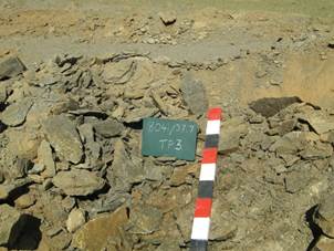
Geotechnical Testing of Borrow Pit material (Outeniqua Lab EC cc.)
Table 1:
Details of Applicant
|
ITEM
|
APPLICANT CONTACT DETAILS
|
|
Name
|
Department of Roads & Public Works
|
|
Tel No:
|
(040)
602 4000
|
|
Fax No:
|
(040)
602 4001
|
|
Call centre:
|
0800 864 951
|
|
Postal Address
|
Private
Bag X0022, Bhisho, 5605
|
Table 2: Details of Consultant
1.7
Report Structure
This
report is divided into 9 chapters:
Chapter
1:
Consists
of the project introduction, background and Regional Context of the mining
application and the area in which the Borrow Pits are located.
Chapter
2:
Specific
Information relating to the individual Borrow Pits, grouped per borrow pit,
addressing the following sections of the MPRDA:
·
REGULATION 52 (2): Description of the environment likely to be
affected by the proposed prospecting or mining operation
a)
The environment on site relative to the environment in the surrounding
area.
b)
The specific environmental features on the site applied for which may
require protection, remediation, management or avoidance.
c)
Map showing the spatial locality of all environmental, cultural/heritage
and current land use features identified on site.
d)
Confirmation that the description of the environment has been compiled
with the participation of the community, the landowner and interested and
affected parties,
Chapter
3:
·
REGULATION 52 (2) (b): Assessment of the potential impacts of the
proposed prospecting or mining operation on the environment, socio- economic
conditions and cultural heritage.
a)
Description of the proposed prospecting or mining operation.
i.
The main prospecting activities (e.g. access roads, topsoil storage
sites and any other basic prospecting design features )
ii.
Plan of the main activities with dimensions
iii.
Description of construction, operational, and decommissioning phases.
iv.
Listed activities (in terms of the NEMA EIA regulations)
b)
Identification of potential impacts (Refer to the guideline)
c)
Potential impacts per activity and listed activities.
i.
Potential cumulative impacts.
ii.
Potential impact on heritage resources
iii.
Potential impacts on communities, individuals or competing land uses in
close proximity. (If no such impacts are identified this must be specifically
stated together with a clear explanation why this is not the case.)
iv.
Confirmation that the list of potential impacts has been compiled with
the participation of the landowner and interested and affected parties,
v.
Confirmation of specialist report appended (Refer to guideline)
·
REGULATION 52 (2) (c): Summary of the assessment of the
significance of the potential impacts and the proposed mitigation measures to
minimise adverse impacts.
a)
Assessment of the significance of the potential impacts
i.
Criteria of assigning significance to potential impacts
ii.
Potential impact of each main activity in each phase, and corresponding
significance assessment
iii.
Assessment of potential cumulative impacts.
Chapter
4:
3.
REGULATION 52 (2) (c): Summary of the assessment of the significance of
the potential impacts and the proposed mitigation measures to minimise adverse
impacts.
a)
Proposed mitigation measures to minimise adverse impacts.
i.
List of actions, activities, or processes that have sufficiently
significant impacts to require mitigation.
ii.
Concomitant list of appropriate technical or management options (Chosen
to modify, remedy, control or stop any action, activity, or process which will
cause significant impacts on the environment, socio-economic conditions and
historical and cultural aspects as identified. Attach detail of each technical
or management option as appendices)
iii.
Review the significance of the identified impacts (After bringing the
proposed mitigation measures into consideration).
Chapter
5:
4.
REGULATION 52 (2) (e): Planned monitoring and performance assessment of the
environmental management plan.
a)
List of identified impacts requiring monitoring programmes.
b)
Functional requirements for monitoring programmes.
c)
Roles and responsibilities for the execution of monitoring programmes.
d)
Committed time frames for monitoring and reporting.
5.
REGULATION 52 (2) (f): Closure and environmental objectives.
a)
Rehabilitation plan (Show the areas and aerial extent of the main
prospecting activities, including the anticipated prospected area at the time
of closure).
b)
Closure objectives and their extent of alignment to the pre-mining
environment.
c)
Confirmation of consultation (Confirm specifically that the
environmental objectives in relation to closure have been consulted with
landowner and interested and affected parties).
Chapter
6:
6.
REGULATION 52 (2) (g): Record of the public participation and the
results thereof.
a)
Identification of interested and affected parties. (Provide the
information referred to in the guideline)
b)
The details of the engagement process.
i.
Description of the information provided to the community, landowners,
and interested and affected parties.
ii.
List of which parties identified in 7.1 above that were in fact
consulted, and which were not consulted.
iii.
List of views raised by consulted parties regarding the existing
cultural, socio-economic or biophysical environment.
iv.
List of views raised by consulted parties on how their existing
cultural, socio-economic or biophysical environment potentially will be
impacted on by the proposed prospecting or mining operation.
v.
Other concerns raised by the aforesaid parties.
vi.
Confirmation that minutes and records of the consultations are appended.
vii.
Information regarding objections received.
c)
The manner in which the issues raised were addressed.
Chapter 7
7.
SECTION 39 (3) (c ) of the Act: Environmental awareness plan.
a)
Employee communication process (Describe how the applicant intends to
inform his or her employees of any environmental risk which may result from
their work).
b)
Description of solutions to risks (Describe the manner in which the risk
must be dealt with in order to avoid pollution or degradation of the
environment)t.
c)
Environmental awareness training (Describe the general environmental
awareness training and training on dealing with emergency situations and remediation
measures for such emergencies).
Chapter
8:
8.
REGULATION 52 (2) (d): Financial provision. The applicant is required
to-
a)
Plans for quantum calculation purposes (Show the location and aerial
extent of the aforesaid main mining actions, activities, or processes, for each
of the construction operational and closure phases of the operation).
b)
Alignment of rehabilitation with the closure objectives (Describe and
ensure that the rehabilitation plan is compatible with the closure objectives
determined in accordance with the baseline study as prescribed).
c)
Quantum calculations (Provide a calculation of the quantum of the
financial provision required to manage and rehabilitate the environment, in
accordance with the guideline prescribed in terms of regulation 54 (1) in
respect of each of the phases referred to).
d)
Undertaking to provide financial provision (Indicate that the required
amount will be provided should the right be granted).
Chapter 9
9.
SECTION 39 (4) (a) (iii) of the Act: Capacity to rehabilitate and manage
negative impacts on the environment.
a)
The annual amount required to manage and rehabilitate the environment
(Provide a detailed explanation as to how the amount was derived)
b)
Confirmation that the stated amount correctly reflected in the
Prospecting Work Programme as required
10.
REGULATION 52 (2) (h): Undertaking to execute the environmental
management plan.
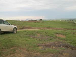
Existing gravel
roads subject to the proposed project in the Intsika Yethu, Sakhisizwe &
Engcobo Local Municipalities have been identified by the department of Roads
and Public Works as being in need of maintenance and re-gravelling. The
specific roads in the abovementioned Local Municipal Areas are the DR08248, DR08247, DR08041 and the DR8504 roads.
Gravel roads weather over relatively short periods of time and require
periodical re-gravelling. The gravel roads identified for re-gravelling display
defects such as corrugation, ravelling, and exposed oversized stones.
The roads to be
re-gravelled provide access to remote villages and the poor quality of the
roads have a significant impact on the lives of the local residents as
alternative routes to nearby towns are often too far to travel and add extra
costs to travel for individuals.
In order to
re-gravel the specified roads, large amounts of material is deeded for mostly
the wearing course of the road. In some cases the material is of such a nature
that is can be grid rolled to the appropriate size, and in others the material
would be crushed due to the physical properties of the material. Quality
control of material would include blending harder materials with fines to
obtain an optimal material quality. The extensions of existing borrow pits for
the collection of materials for the specified roads is being proposed.
After a preliminary
screening of borrow pits along the DR08248, DR08247, DR08041 & DR 8504 roads,
15 borrow pits were selected subject to criteria including material type, location,
access, surrounding land use, slope, erosion, hydrology and sensitive
vegetation. Three sites were selected along the DR08248, 5 along the DR08247, 6
along the DR08041 & one along the DR8504 roads. The borrow pits will be
used exclusively for the upgrade/re-gravelling of the road they are situated adjacent
to.
If approved, this
EMP will be used as guidelines for the excavation of material from the proposed
borrow pits and the rehabilitation thereof.
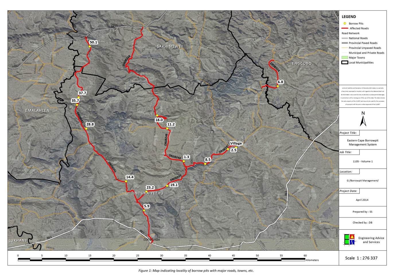
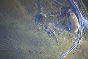
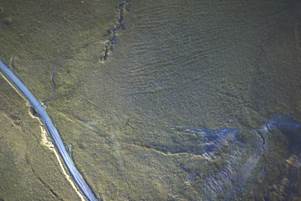
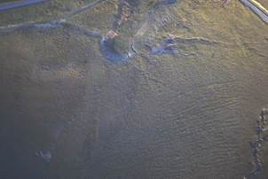
The locations of all the proposed borrow pits and
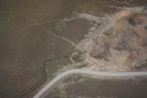
the road sections they are to be used for are shown in figure 1.
The affected roads are situated north of Cofimvaba
and south of Cala. Queenstown is located 76 km West of Cofimvaba and 100
km south-west of Cala (Sakhisizwe).
Table 3: Locality of proposed borrow pits.
|
Road
|
BP
|
Coordinates
|
LMA
|
Land Owner*
|
Comment
|
|
DR08041
|
5.9
|
S31 56.909
|
Intsika Yethu
|
Communal
|
Existing BP site; situated 5.9
km along the DR08041 from the R61 intersection
|
|
E27 34.106
|
|
14.4 RHS
|
S31 53 37.2
|
Intsika Yethu
|
Communal
|
Existing BP site; situated 14.4
km along the DR08041 from the R61 intersection
|
|
E27 32 04.3
|
|
28.8 RHS
|
S31 47 39.8
|
Intsika Yethu
|
Communal
|
Existing BP site; situated 28.8
km along the DR08041 from the R61 intersection.
|
|
E27 27 35.4
|
|
35.7 RHS
|
S31 44 59.6
|
Intsika Yethu
|
Communal
|
Existing BP site; situated 35.7
km along the DR08041 from the R61 intersection.
|
|
E27 26 33.3
|
|
37.7 RHS
|
S31 44 08.4
|
Intsika Yethu
|
Communal
|
Existing BP site; situated 37.7
km along the DR08041 from the R61 intersection.
|
|
E27 26 44.1
|
|
50.1
|
S31 38 24.0
|
Sakhisizwe
|
Communal
|
Existing BP site; situated 5.9
km along the DR08041 from the R61 intersection.
|
|
E27 27 59.0
|
|
DR08247
|
2.5 LHS
|
S31 49 59.366
|
Intsika Yethu
|
Communal
|
Existing BP site; situated 2.5
km along the DR08247 from the DR08038 intersection.
|
|
E27 43 33.517
|
|
8.5 LHS
|
S31 51 39.678
|
Intsika Yethu
|
Communal
|
Existing BP site; situated 8.5
km along the DR08247 from the DR08038 intersection.
|
|
E27 41 3.320
|
|
19.1 LHS
|
S31 54 09.0
|
Intsika Yethu
|
Communal
|
Existing BP site; situated 19.1
km along the DR08247 from the DR08038 intersection.
|
|
E27 36 40.5
|
|
23.2
|
S31 54 48.2
|
Intsika Yethu
|
Communal
|
Existing BP site; situated 23.2
km along the DR08247 from the DR08038 intersection.
|
|
E27 34 22.0
|
|
Village
|
S31 49 48.8
|
Intsika Yethu
|
Communal
|
Existing BP site; situated approximately
1 km along the DR08247 from the DR08038 intersection.
|
|
E27 44 28.6
|
|
DR08248
|
1.3 RHS
|
S31 51 22.136
|
Intsika Yethu
|
Communal
|
Existing BP site; situated 1.3
km along the DR08248 from the DR08247 intersection.
|
|
E27 38 34.865
|
|
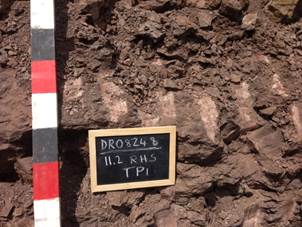
11.2 RHS
|
S31 47 39.85
|
Intsika Yethu
|
Communal
|
Existing BP site; situated 11.2
km along the DR08248 from the DR08247 intersection.
|
|
E27 36 43.75
|
|
18.0 RHS
|
S31 46 11.732
|
Intsika Yethu
|
Communal
|
Existing BP site; situated 18
km along the DR08248 from the DR08247 intersection.
|
|
E27 35 35.143
|
|
DR08504
|
6.8
|
S31 42.885
|
Engcobo
|
Communal
|
Existing Borrow Pit; situated 6.8
km along DR08504
|
|
E27 49.177
|
*Communal –
Department of Rural Development and Land Reform
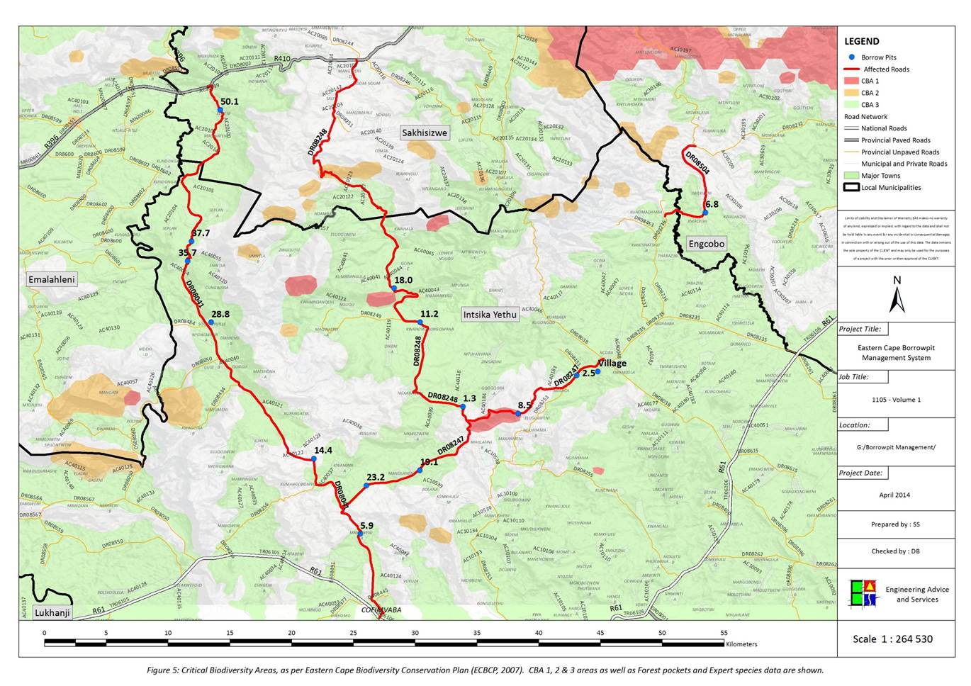
A screening of Regional Biodiversity Features was
undertaken, based on a model developed that included the following features:
1.
Protected areas
2.
World Heritage Sites and their legally proclaimed buffers
3.
Critically Endangered and Endangered ecosystems
4.
Critical Biodiversity Areas
5.
River and wetland Freshwater Ecosystem Priority Areas (FEPAs), and
6.
100 m Buffer of rivers and wetlands
7.
RAMSAR Sites
8.
Protected area buffers
9.
Trans-frontier Conservation Areas (remaining areas outside of formally
proclaimed PAs)
10.
High water yield areas
11.
Coastal Protection Zone
12.
Estuarine functional zones
13.
Ecological support areas
14.
Vulnerable ecosystems
15.
Focus areas for land-based protected area expansion and focus areas.
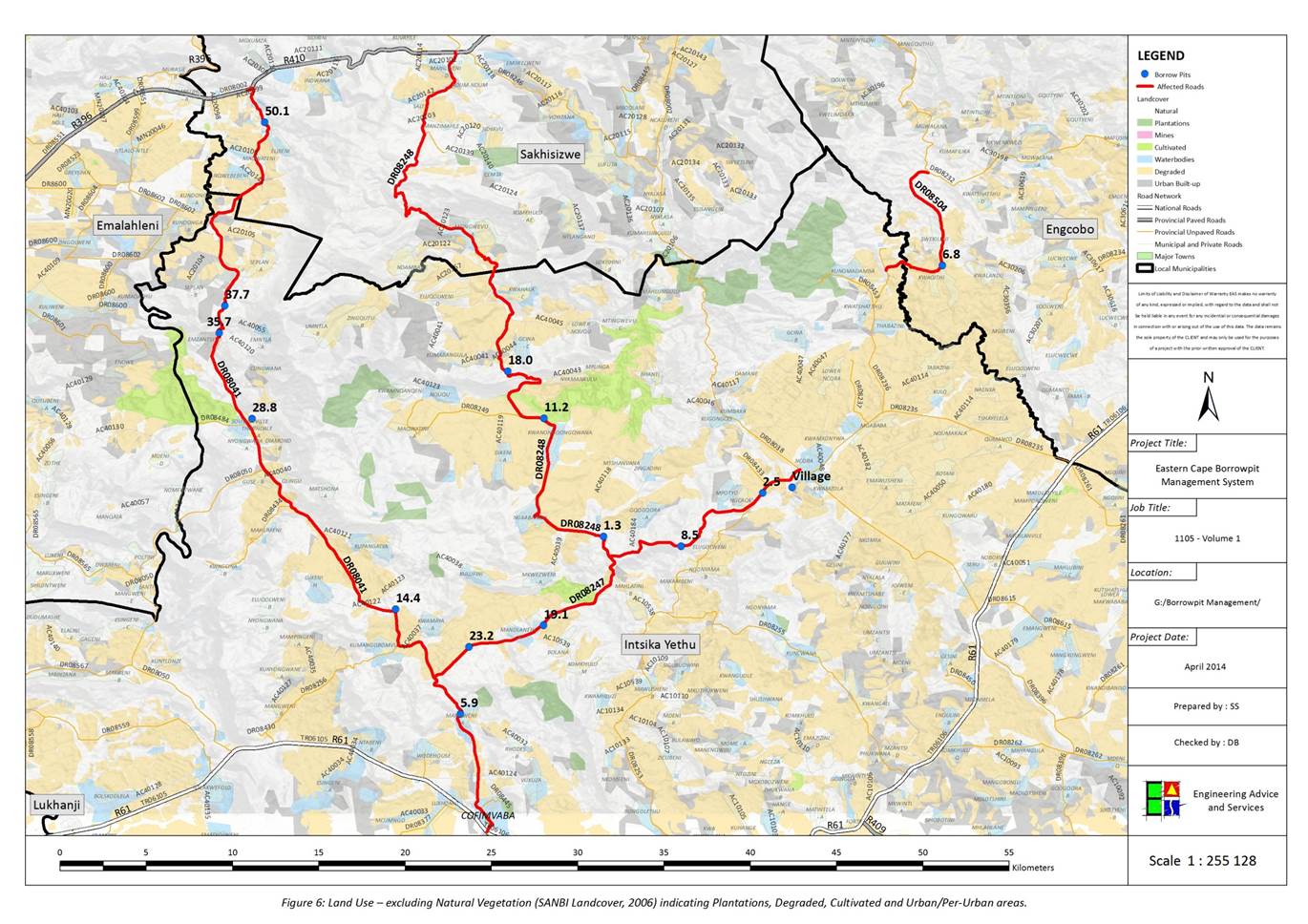
A summary of these features (illustrated in Figure 4 to Figure 6) is provided in Table 4 below.
Table 4: Summary of Biodiversity features for the
Borrow Pit sites.
|
Borrow Pit
|
Vegetation Type:
|
Status
|
Present land use:
|
CBA
|
|
8041/5.9
|
Tsomo Grassland
|
Vulnerable
|
Urban Built-up
|
CBA 3
|
|
8041/14.4
|
Drakensberg Foothill Moist Grassland
|
Least Concern
|
Natural
|
|
|
8041/28.8
|
Tsomo Grassland
|
Vulnerable
|
Natural
|
CBA 3
|
|
8041/35.7
|
Tsomo Grassland
|
Vulnerable
|
Natural
|
CBA 3
|
|
8041/37.7
|
Tsomo Grassland
|
Vulnerable
|
Natural
|
CBA 3
|
|
8041/50.1
|
Tsomo Grassland
|
Vulnerable
|
Natural
|
CBA 3
|
|
8247/2.5
|
Tsomo Grassland
|
Vulnerable
|
Natural
|
CBA 3
|
|
8247/8.5
|
Southern Mistbelt Forest
|
Vulnerable
|
Natural
|
CBA 1
|
|
8247/19.1
|
Tsomo Grassland
|
Vulnerable
|
Urban Built-up
|
CBA 3
|
|
8247/23.2
|
Tsomo Grassland
|
Vulnerable
|
Natural
|
CBA 3
|
|
8247/Village
|
Tsomo Grassland
|
Vulnerable
|
Urban Built-up
|
CBA 3
|
|
8248/1.3
|
Drakensberg Foothill Moist Grassland
|
Least Concern
|
Natural
|
|
|
8248/11.2
|
Tsomo Grassland
|
Vulnerable
|
Cultivated and Degraded
|
CBA 3
|
|
8248/18.0
|
Tsomo Grassland
|
Vulnerable
|
Natural
|
CBA 3
|
|
8504/6.8 (EMP)
|
Tsomo Grassland
|
Vulnerable
|
Cultivated and Degraded
|
CBA 3
|
The locations of all
the proposed borrow pits and the road sections they are to be used for are
shown in Figure 1. The affected roads are situated South-East of Cala
and North-West of Engcobo. Queenstown is located 140
km West of Engcobo and 100 km south-west of Cala (Sakhisizwe). They are
situated on the DR08041, DR08247, DR08248 and DR08504.
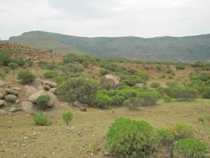
The surrounding area can generally be described as
flat or gentle undulating lowland plains intersected by moderately rolling
hills and mountains, much incised by river gorges. Drainage of the region is
mainly in a southerly direction.
As per the Geological Map in Figure
2, the Geology in the region consists of the following:
|
Symbol
|
Lithology
|
Formation
|
|
Jd
|
Volcanic Rocks, gabbro, pikriet
|
Karroo
sequence, Drakensberg Group
|
|
Jdb
|
Volcanic Rocks, Basaltic Lava, subordinate
tuff and agglomerate
|
Drakensberg Group
|
|
TRm
|
Volcanic Rocks, Basaltic Lava,
subordinate tuff and agglomerate
|
Karroo
sequence, Drakensberg Group, Molteno Formation
|
|
TRb
|
Brownish Red
and grey mudstone, sandstone (Sedimentary)
|
Karroo
sequence, Beaufort Group, Tarkastad subgroup, Burgersdorp Formation
|
|
TRe
|
Brownish-red and grey mudstones,
sandstone
|
Drakensberg Group, Elliot Formation
|
|
Alluvium
|
Alluvium
|
|
The study area is underlain mostly by sedimentary
rocks of the Early Triassic Period Karoo Supergroup, which was formed under
fluvial conditions when the inland Karoo Sea was drying out and wide plains
were being carved by large river systems. These rivers deposited the sands and
muds on broad flood plains which over time became interbedded sandstone and
mudstone of the Katberg and Burgersdorp Formations (both of the Tarkastad
Subgroup, Karoo Supergroup).
The Katberg Formation has been mapped in the
southern and south-western part of the site and is dominated by sandstone
lithologies formed by multi-channelled braided river environments. The braided
river system resulted in the development of a deeply eroded landscape with few
fine-grained (mud and silt) overbank deposits developing. This formation
therefore consists mainly of sandstone with sub-ordinate argillaceous (rock
containing clay) maroon-coloured mudstone.
A return to a meandering river system is reflected
in the mudstone-dominated strata of the Burgersdorp Formation, which has been
mapped in the eastern and north-eastern parts of the study area. This formation
is dominated by maroon, grey and olive-coloured mudstone and is considered a
distal equivalent to that of the Katberg Formation.
These Beaufort Group rocks are interrupted by
doleritic dykes (vertical intrusion) and sills (horizontal intrusion) formed
during the Jurassic Period. These intrusions forced their way between the
sedimentary strata during the eruption phases that formed the Drakensberg Group
basalts. The sedimentary rocks into which the dolerite intruded are often
altered (metamorphosed) in aureoles adjacent to intrusions (e.g. Hornfels). The
dolerite has a regional north-south trend around which the Sabalele Road has
been constructed. This material is, therefore, likely to be intersected in
outcrop in the southern part of the study area.
Geotechnical Interpretation
The Karoo Supergroup rocks generally reveal a
subdued topography in the study area with a variable weathering profile. The
sandstone lithologies tend to be more weathering resistant and are blanketed by
a thinner soil cover than that of the softer, mudstone rocks. The completely
weathered rock/ residual soil interface is commonly susceptible to dispersion
and piping erosion, resulting in the development of the characteristic
donga-marked landscape where sloping ground prevails.
The sandstone lithologies have a rock strength
that is often considered too low for use as base course or sub base, yet it is
too high (and has little binding capabilities) for use as a crushed wearing
course on unsurfaced roads. This material is likely to require crushing for any
aggregate application. The mudstone rocks also have a rock strength that is
considered too low for use as base course or sub base. The rock is, however,
often a preferred material for gravel wearing course applications, and breaks
down easily on the roadway during mechanical placement. Most of the Karoo
Supergroup rocks are considered suitable for select subgrade applications.
The intrusive dolerites can be highly variable in
terms of rock strengths and weathering profiles. The geotechnical properties of
these rocks are often affected by the cooling rates of the magma when they were
formed; slow cooling magma forms larger crystals that develop into high
strength rocks, whilst quickly cooling magma forms smaller crystals that can
eventuate into low strength rocks. The dolerite also displays a weathering
profile that can be deep (tens of metres) and dominated by fresh rock core
stones of variable sizes, or shallow weathering with soil cover often less than
one metre underlain by competent rock without core stones. The weathering
profiles and rock strengths of dolerite are not easily ascertainable based on
surface outcrop. It is common, nevertheless, for the dolerite outcrop to reveal
a positively weathered landform in the study area, frequently associated with a
very different vegetation cover to that of the surrounding Karoo Supergroup
rocks.
The extremely weathered dolerite reveals a deep
red-coloured soil cover often pock-marked with sub-rounded and well-rounded
dolerite core stones. These weathered soils are often highly dispersive and
erosion scours are common in areas where positive relief is not offered
adequate protection from vegetation cover. Doleritic soil is frequently highly
expansive and considered unsuitable for any road construction application. The
materials’ construction suitability improves with depth as the highly weathered
rock (Sabunga) is considered suitable for gravel wearing course use in arid
environments, whilst the moderately weathered, slightly weathered and fresh
rock is a well-documented source of good sub base and base course.
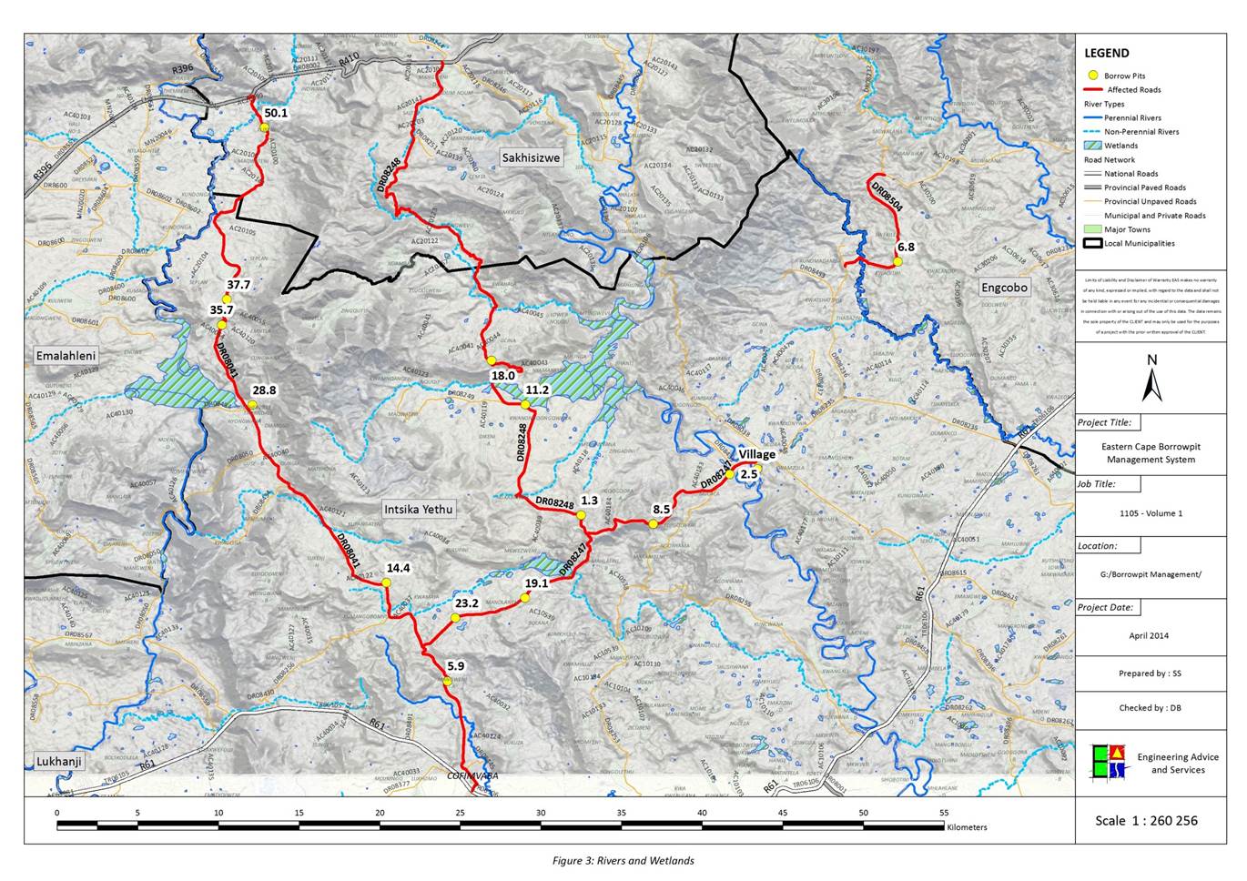
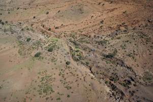
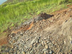
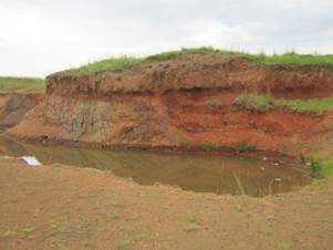
The drainage of the area generally flows in a
southerly direction (Figure 3). The Tsomo and Mgwali Rivers are the main
drainage systems. The minor seasonal streams in the surrounding area in
proximity to the Borrow Pits are tributaries of these rivers. Where Borrow
Pits are in the vicinity of drainage lines and rivers, stormwater and runoff
will need to be adequately managed to prevent increased turbidity of downstream
river systems. With the proper implementation of the EMP it likely that any
existing impacts that are currently present will be reduced. Rivers area
indicated on the close-up maps of the individual Borrow Pit descriptions.
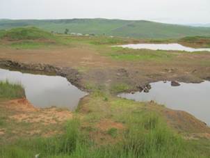
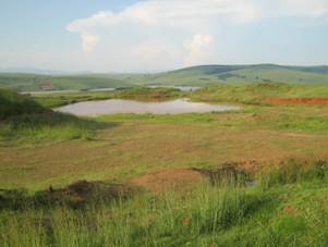
Some wetlands (Natural and artificial) may be in
proximity to seasonal wetlands. As for drainage lines above, runoff will need
to be managed and will be dealt with in Borrow Pit descriptions accordingly.
After rehabilitation of the Borrow Pits, some areas will probably be natural
accumulation areas for runoff from surrounding areas and become small dams or
artificial wetlands in the long-term.
Groundwater resources could potentially be
affected by the mining of Borrow pits due to inadvertent fuel and chemical
spills. If the management measure prescribed below are adhered to it is not
anticipated that groundwater resources would be significantly affected by the
Borrow Pits.
The area is a predominantly summer rainfall area.
The mean annual rainfall for Engcobo (809.9
mm), decreasing westwards. Mean annual temperatures in the Engcobo area is 16.7°C.
Air quality levels in rural areas surrounding the
Borrow Pit sites are typically good. The gravel roads are however a source of
dust, especially during dry windy conditions. Air quality may be temporarily
affected by the mining and concomitant road surfacing operations during the
routine maintenance periods.
The Borrow pit sites are generally situated
relatively close to provincial gravel roads, which are an existing source of
noise. The current ambient noise levels are assumed to be relatively high due
to road traffic. Noise receptors during mining operations would typically be
residents in the villages nearest to the sites.
The Beaufort Group is Late Permian (255 million
years) to Mid Triassic (237 million years) in age. Characteristic fossils
include fish, amphibians and reptiles with a dominance of mammal-like reptiles
(Theraptids). In addition, characteristic fossils include plant fossils of the
Glossopteris flora with occasional invertebrate fossils (freshwater
bivalve molluscs). Most of the fossil specimens represent groups that are now
extinct. It is estimated that less than 5 % of sites have been identified in
the Eastern Cape. There is a lack of identified sites in the District.
An internationally important record of life during
the early diversification of land vertebrate is provided by the floodplain of
the Beaufort Group (Karoo Supergroup). Giant amphibian coexisted with diapsid
reptiles (the ancestors of dinosaurs, birds and most modern reptiles), anapsids
(which probably include the ancestors of tortoises) and synapsids, the dominant
of the group of the time which included the diverse therapsids (including the
ancestors of mammals). The rocks provide the world’s most complete record of
the important transition from early reptiles to mammals.
Most plant and animals were decimated during the
end-Permian extinction event with Therapsid diversity being a serious contender
for the most severe extinction event to affect life on Earth. Ongoing research
on the effects of this extinction event is facilitated by the detailed record
(afforded by the Beaufort Group strata) of life immediately before and after
the event, as well as the gradual recovery of life afterwards.
The Beaufort Group is subdivided into a series of
biostratigraphic units on the basis of its faunal content. There is a marked
faunal change that occurs between the Dicynodon and Lystrosaurus
Assemblage Zones and approaches the tops of the Balfour Formation. This
corresponds with the major extinction event associated with the Perno-triassic
boundary. The Lustrosaurus Assemblage Zone spans the uppermost
(Palingkloof) member of the Balfour Formation, the Katberg Formation (Tarkastad
Subgroup, Beaufort Group, Karoo Supergroup) and the lower part of the
Burgersdorp Formation (Tarkastad Subgroup, Beaufort Group, Karoo Supergroup).
The Lystrosaurus Assemblage Zone is
dominated by a single genus of dicynodont, Lyystrosaurus, which together
with the captorhinid reptile (Procolophon) characterise this zone.
Biarmosuchian and gorgonopsian Therapside do not survive into the Lystrosaurus
Assemblage Zone, though therocephalian and cyndontian Therapside exhibit
moderate abundance. Captohinid Reptilia are reduced, however, an unprecedented
diversity of giant amphibian characterises this interval.
The effect of the end Permian extinction event are
also evident in the extensive and important record of fossil plants present in
the rocks of the Karoo. Whereas faunas of the Permian age are dominated by a
wide range of early seed plants, the Glossopteridale (which probably include
the ancestors of modern gymnosperms and ultimately angiosperms), this group
appears to have gone entirely extinct during the end-Permian extinction. The
rocks of the Karoo provide an unrivalled sequential record of these change and
the diversification of other group of plants in the aftermath of the
extinction. The strata of the Karoo basin have also yielded fossils insects and
insect leaf damage of a range of ages.
Though including the uppermost level of the Lystrosaurus
Assemblage Zone, the Burgersdorp Formation largely corresponds to the Cynognathus
Assemblage Zone. Synapsid therapsid diversity does not demonstrate recovery
between the Lystrosaurus and Cynognathus assemblage zones. The Dicynodontia,
Lystrosaurus and Myosaurus are replace by Kombuisia and the
giant Kannemeyeria. Therocephalia exhibit a turnover of taxa at a
generic level, but an overall reduction in diversity. Cynodontia (Therapsida,
Synasida) alone amongst synapsids demonstrate a slight increase in genera.
These include the small advance Cynodont, Cynognathus, which together
with the Cynodont Diademodon and the Dicynodont Kannemeyeria, characterise
this assemblage zone. Eosuchid and captorhinid Reptilia are moderately common,
though showing no generic continuity with taxa of the underlying zone. Amphibia
remain diverse, though they are not as generically diverse as in the Lystosaurus
Assemblage Zone and likewise demonstrate no genus level continuity therewith.
Fossil fish reach their greatest known Karoo Supergroup diversity in the
Burgersdorp Formation (Cynognathus Assemblage Zone). Plants (Dadoxylon,
Dicroidium and Schizoneura), trace fossils (including both
vertebrate and invertebrate burrows) and a freshwater bivalve (Unio
karooensis) have also been recovered.
As Dolerite is an intrusive igneous rock, it
contains no fossils.
Archaeological remains can consist of the following:
1.
Human remains (graves, informal graves and cemeteries)
2.
Stone artefacts and tools
3.
Large Stone Features (Isisivane and circular stone walls)
4.
Freshwater shell middens
5.
Historical artefacts and features
6.
Fossil Bone
1 Human Remains
Any, and all, human remains that are exposed during
all phases of construction must be reported to the archaeologist, nearest
museum or relevant heritage resources authority. Construction must then be
halted until the archaeologist has investigated and removed the human remains.
Human remains may be exposed when a grace or informal burial has been
disturbed. Remains are either buried in a flexed position on the side, or in a
sitting position with a flat stone capping the location of the burial.
Developer are requested to be aware of the exposing human remains.
2 Stone Artefacts
Stone artefacts can be difficult for the layman to
identify. Large accumulations of flaked stones that do not appear to have been
distributed naturally must be reported. If the stone artefacts are associated
with bone / faunal remains or any other associated organic and material
cultural artefacts, development must be halted immediately and reported to the
archaeologist, nearest museum or relevant heritage resources authority.
3 Large Stone Features
Even though large stone features occur in different
forms and sizes, they are relatively easy to identify. The most common features
are roughly circular walls (most collapsed), usually dry packed stone, and may
represent: stock enclosures, the remains of wind breaks or cooking shelters.
Other features consist of large piles of stones of different sizes and height
that are known as isisivane. These features generally occur near river
and mountain crossings. The purpose and meaning of the isisivane are not
fully understood, however, interpretations include the representation of burial
cairns and symbolic value.
4 Freshwater Shell Middens
Accumulations of freshwater shell middens
comprising mainly freshwater mussel occur along the muddy banks of rivers and
streams and were collected by pre-colonial communities as a food resource. The
freshwater shell middens generally contain; stone artefacts, pottery, bone and
(sometimes) human remains. Freshwater shell middens may be of various sizes and
depths. An accumulation that exceeds 1
m² in extent must be report to the archaeologist, nearest museum or relevant
heritage resources authority.
5 Historical Artefact and Features
These are relatively easy to identify and include
the foundations and remain of buildings, packed dry stone walling representing
domestic stock kraals. Other items include historical domestic artefacts such
as: ceramics, glass, metal and military artefacts and dwellings.
6 Fossil Bones
Fossil bones may be embedded in geological
deposits. Any concentrations of bone (whether fossilized of not) must be
reported to the archaeologist, nearest museum or relevant heritage resources
authority.
As indicated in Figure
6 the Borrow Pits are predominantly located within or adjacent to areas
classified as Degraded, Cultivated and in some cases (Peri) Urban as per the
SANBI Land Cover (2009) map.
The erosion potential of soils is the sensitivity
of soils to the effects of wind and water on the soil structure. The
erodability index is determined by combining the effects of slope and soil
type, rainfall intensity and land use. A low value indicates a high erosion
risk and a high value indicates a low erosion risk. The area falls within an
erodability index of between 7 and 9, indicating that the area has a moderate
to high susceptibility to erosion. Adequate measures must thus be implemented
to minimise erosion.
At a regional level, two vegetation types are
recognised within the immediate vicinity of the borrow pit sites (Mucina & Rutherford, 2006), which are namely Drakensberg Foothill Moist Grassland and
Tsomo Grassland (Figure 4). Drakensberg Foothill Moist Grassland having a
conservation status of Least Threatened and Tsomo Grassland being Vulnerable
(Mucina & Rutherford, 2006).
Distribution ranges within the KwaZulu-Natal and
Eastern Cape Provinces. Broad arc of Drakensberg piedmonts covering the
surrounds of Bergville in the north, Nottingham Road, Impendle, Bulwer in the
east, and Kokstad, Mount Currie, Underberg (KZN) and the surrounds of Mt
Fletcher, Ugie, Maclear and Elliot (Eastern Cape) in the southwest
Present on moderately rolling and mountainous,
much incised by river gorges of drier vegetation types and by forest, and
covering forb-rich grassland dominated by short bunch grasses including Themeda
triandra and Tristachya leucothrix
The geology is dominated by mudstones and
sandstones of the Tarkastad and the Molteno Formation (Karoo Supergroup) as
well as intrusive dolerites of Jurassic age. The dominant soil on the
sedimentary parent material are well drained, with a depth of more than 800
mm and lay content from 15 – 55 %, representing soil forms such as Hutton,
Clovelly, Griffin and Oatsdale. On the volcanic parent material (dolerite) the
soils are represented by forms such as Balmoral, Shortlands and Vimy. Most
common land types are Ac and Fa.
Conservation: Least threatened. Target 23%.
Only 2–3% statutorily conserved in the uKhahlamba Drakensberg Park, Ntsikeni
Wildlife Reserve as well as in the Karkloof, Mount Currie, Coleford, Fort
Nottingham, Impendle, Ngeli, and Umgeni Vlei Nature Reserves. Almost 20%
already transformed for cultivation, plantations and by urban sprawl. Alien
woody species of Rubus and Acacia dealbata and Solanum mauritianum may become
invasive in places. Erosion is very low to moderate.
NSBA (2011) Conservation status: Least
threatened
NSBA (2011) Conservation Target (% of area):
23%
Present in the region to the east of the Queenstown
basin, with the villages of Tsomo, Cala and Engcobo defining the eastern extent
and Cathcart, Queenstown and Sterkstroom the western extent.
Present on flat or gentle undulating lowland
plains intersected by mountains. The vegetation is grassland or open
Thornveld, often grazed short or replaced by dwarf shrubland dominated by
species of Euryops. Dominant and common species include omnipresent
representatives of the genera Cymbopogon, Elionurus, Eragrostis, Aristida
and Themeda. Asteraceae and Fabaceae are prominent among the forbs.
The vegetation shows various stages of overutilization and also a gradient from
grassland to Thornveld. Mountain ridges within this unit are often wooded and
this woody component easily spreads into the surrounding vegetation when
ecological conditions permit. Many of the other vegetation units in the
region, both grassland and woody vegetation, grade into this one, so that there
is a naturally high rate of species turnover.
Occurs predominantly on Mudstones of the Tarkastad
Subgroup overlain mostly by soils of moderate depth.
Conservation: Vulnerable. Target -
23 %. None conserved in statutory conservation areas. Only 1 % conserved in
private reserves. Some 27 % transformed mainly for cultivation and by dense
concentrations of rural settlements. Increased occurrence of alien Schkuhria
pinnata and Tagetes minuta indicates heavy disturbance. Erosion is
a serious problem and it is high in 33 % of this unit, moderate in 32 %, and
low and very low in 34 % of the area.
NSBA (2011) Conservation status: Vulnerable
NSBA (2011) Conservation Target (% of area):
23%
Southern Mistbelt Forest
Distribution ranges within KwaZulu-Natal and
Eastern Cape Provinces: Forest patches varying in size, occurring in
fire-shadow habitats on south- and southeast-facing slopes and located along
the Great Escarpment, spanning a large area from Somerset East, the Amathole
Mountains, scarps of Transkei to the KwaZulu-Natal Midlands as far east as
Ulundi. Found at altitudes spanning 850–1 600 m (most patches between 1 000 and
1 400 m).
Forests are tall grown (15–20 m tall),
multi-layered (having two layers of trees, a dense shrubby understorey and a
very well developed herb layer). The forests of low-lying scarps are low grown
(in places having the character of scrub forest), and although less structured
into different tree layers, they are still very species-rich. The tall-grown
forests show a mix of coarse grain, canopy gap/disturbance driven dynamics and
fine-grained, regeneration characteristics. In the forests of Transkei and
KwaZulu-Natal Midlands, Podocarpus henkelii becomes prominent in the
canopy layer. Deciduous trees play an important structural role here as well.
The geology is dominated by soils that are
well-developed, deep, loamy and with high nutrient status - developed on
weathered dolerite intrusions or mudstones, shales and sandstones of Balfour
Formation (on Main Escarpment); the soils supporting forests of low-lying
scarps are shallower as they developed on Witteberg quartzitic sandstones or
various rocks of Karoo sequence geology.
Conservation: Least threatened. Target 30%.
Some 8% statutorily conserved (including forests under DWAF jurisdiction) in
the Eastern Cape encompassing the Bosberg Nature Reserve, Greater Addo Elephant
National Park as well as Hogsback, Kologha, Isidenge, Kubusi, Katberg and
Nabakyu State Forests. In KwaZulu-Natal these forests are statutorily protected
in Impendle, Igxalingenwa, Karkloof and Qudeni Nature Reserves. Several private
reserves protect smaller patches. About 5% has been transformed for
plantations. Invasive aliens include Solanum mauritianum, Rubus species and
several Acacia and Eucalyptus species. Uncontrolled harvesting of timber, poles
and firewood, overexploitation of non-timber forest products and mismanagement
of fire and burning regimes in surrounding grasslands are considered as current
major threats (Von Maltitz et al. 2003).
NSBA (2011) Conservation status: Least
threatened
NSBA (2011) Conservation Target (% of area):
30%
Critical biodiversity areas (CBAs) are terrestrial
and aquatic features in the landscape that are critical for conserving
biodiversity and maintaining ecosystem functioning (SANBI 2007). These form the
key output of the conservation plan. They are used to guide protected area
selection and should remain in their natural state as far as possible.
As indicated in Figure
5, the Eastern Cape Biodiversity Conservation Plan (ECBCP, 2007) the Borrow
Pits are predominantly situated in areas designated a CBA 3 status
(terrestrial), with a few either outside of designated CBA areas. Due to the
limited size of these Borrow Pits, their effect on Critical Biodiversity Areas
will be minimal. Individual Borrow Pits that are within CBA 1 or CBA 2 areas
will be highlighted and appropriate measures recommended in the Impact and
Mitigation sections of the report where necessary.
No Borrow Pits are located within designated
Reserves (class 1 and class 2) none are within aquatic CBA’s.
The expansion of the borrow pits is unlikely to compromise
the vegetation units significantly due to:
15.
The small mining footprint.
16.
The generally degraded state of the existing borrow pits and immediate
vicinity.
17.
The general close proximity to the road reserves.
18.
The implementation of a formalized rehabilitation plan.
Loss of vegetation cover will thus tend to be
highly localised and have a minimal impact (individual and cumulative) at a
regional level. Furthermore it will most likely result in an overall
improvement of the ecological integrity of existing sites that currently tend
to be in a highly degraded state, as a result of inadequate historical
remediation methods.
The impact of the expansion of existing Borrow
Pits, generally located directly adjacent to roads in areas that are generally
degraded is unlikely to have any significant negative impact on ecological
processes occurring at a regional level. The implementation of best practice
guidelines (as per the EMP) will most likely be effective management to
minimise any negative consequences to being located within Critical
Biodiversity Areas. In addition, since the existing Borrow Pits are currently
inadequately managed, the implementation of the recommended management actions
in the EMP will most likely result in an improvement to the status quo.
Any Borrow Pits that are significantly affected by
the Regional Planning Frameworks will be dealt with accordingly in their
relative Impact and Mitigation sections.
Based on a desktop Assessment of existing online
databases as well as field verification, the potential list of flora and fauna
species that may occur in the vicinity of the Borrow Pits, is quite extensive.
Common flora species such as: Aloe arborescens, Aloe ferox, Aloe maculata,
Bulbine abyssinica and Boophone disticha, are common around some of
the sites.
The Giant Bull Frog, may be present in wetlands,
but are unlikely to be affected by the Borrow Pits, which will not likely
impact on any wetlands.
Appendix E provides a detailed list of species
protected in term of the P.N.C.O., for which permits may be required should
they occur. However limited field assessments indicate that the majority of
these species are unlikely to be present. Due to limited sampling time, Presence
or absence cannot be confirmed without detailed seasonal site visits, but the
risk of any Critically Endangered or Endangered species being present is Low.
The limited expansion of the Borrow Pits is thus unlikely to result in any
significant impact to species conservation.
No Red Listed Critically Endangered or Endangered
species are recorded for the area.
Table 5: Species of Special Concern known to occur in the vicinity of the sites.
|
Scientific Name
|
Family
|
Common name
|
Status
|
Endemic
|
|
Flora
|
|
Albuca setosa
|
HYACINTHACEAE
|
|
PNCO
|
|
|
Aloe arborescens
|
ASPHODELACEAE
|
|
PNCO
|
|
|
Aloe ferox
|
ASPHODELACEAE
|
|
PNCO
|
|
|
Aloe maculata
|
ASPHODELACEAE
|
|
PNCO
|
|
|
Aristea anceps
|
IRIDACEAE
|
|
PNCO
|
|
|
Bergeranthus multiceps
|
MESEMBRYANTHEMACEAE
|
|
PNCO
|
|
|
Boophone disticha
|
AMARYLLIDACEAE
|
|
PNCO
|
|
|
Brunsvigia grandiflora
|
AMARYLLIDACEAE
|
|
PNCO
|
|
|
Bulbine abyssinica
|
ASPHODELACEAE
|
|
PNCO
|
|
|
Bulbine asphodeloides
|
ASPHODELACEAE
|
|
PNCO
|
|
|
Bulbine narcissifolia
|
ASPHODELACEAE
|
|
PNCO
|
|
|
Cyrtanthus macowanii
|
AMARYLLIDACEAE
|
|
PNCO
|
|
|
Delosperma repens
|
MESEMBRYANTHEMACEAE
|
|
PNCO
|
|
|
Dierama atrum
|
IRIDACEAE
|
|
PNCO
|
|
|
Dietes iridioides
|
IRIDACEAE
|
|
PNCO
|
|
|
Drimia macrocentra
|
HYACINTHACEAE
|
|
PNCO
|
|
|
Eulophia foliosa
|
ORCHIDACEAE
|
|
PNCO
|
|
|
Gasteria excelsa
|
ASPHODELACEAE
|
|
PNCO
|
|
|
Gladiolus longicollis subsp. longicollis
|
IRIDACEAE
|
|
PNCO
|
|
|
Gladiolus mortonius
|
IRIDACEAE
|
|
PNCO
|
|
|
Haemanthus humilis subsp. humilis
|
AMARYLLIDACEAE
|
|
PNCO
|
|
|
Holothrix scopularia
|
ORCHIDACEAE
|
|
PNCO
|
|
|
Hypoxis acuminata
|
HYPOXIDACEAE
|
|
PNCO
|
|
|
Hypoxis angustifolia var. buchananii
|
HYPOXIDACEAE
|
|
PNCO
|
|
|
Ledebouria cooperi
|
HYACINTHACEAE
|
|
PNCO
|
|
|
Ledebouria revoluta
|
HYACINTHACEAE
|
|
PNCO
|
|
|
Ornithogalum longibracteatum
|
HYACINTHACEAE
|
|
PNCO
|
|
|
Ornithogalum tenuifolium subsp.
tenuifolium
|
HYACINTHACEAE
|
|
PNCO
|
|
|
Ruschia putterillii
|
MESEMBRYANTHEMACEAE
|
|
PNCO
|
|
|
Satyrium longicauda var. longicauda
|
ORCHIDACEAE
|
|
PNCO
|
|
|
Satyrium parviflorum
|
ORCHIDACEAE
|
|
PNCO
|
|
|
Watsonia densiflora
|
IRIDACEAE
|
|
PNCO
|
|
|
Watsonia pillansii
|
IRIDACEAE
|
|
PNCO
|
|
|
Mammals
|
|
Myotis tricolor
|
VESPERTILIONIDAE
|
Temminck's Hairy Bat
|
Near Threatened
|
|
|
Reptiles
|
|
None
|
|
|
|
|
|
Amphibians
|
|
Pyxicephalus adspersus
|
PYXICEPHALIDAE
|
Giant Bull Frog
|
NT
|
|
|
Invertebrates
|
|
Aslauga australis (Butterfly)
|
LYCAENIDAE
|
Southern Purple
|
Data Deficient
|
Yes
|
|
Chrysoritis lyncurium (Butterfly)
|
LYCAENIDAE
|
Tsomo River Opal
|
Vulnerable
|
Yes
|
|
Chrysoritis penningtoni (Butterfly)
|
LYCAENIDAE
|
Pennington's Opal
|
Vulnerable
|
Yes
|
|
Fish
|
|
Clarias gariepinus
|
CLARIIDAE
|
|
NEMBA (NL)
|
|
The plant and animal species of special concern
listed above require permits if any individuals are to be removed, translocated
or pruned according to the relevant legislation including the National Forests
Act and the Provincial Nature Conservation Ordinance as well as Threatened and
Protected Species (T.o.P.S.)
The Borrow Pits will be utilised for routine
maintenance of gravel roads in the area. These roads connect the villages and
urban areas, thus if they are not maintained there will be a negative impact on
the people, their health (safety) and their livelihoods. Furthermore vehicular
‘wear and tear’ results in higher living costs. Formalisation of the Borrow
Pits will allow for regular routine maintenance of the roads that will benefit
not only local communities and residents but also all road users.
No people will be directly affected by the
proposed mining of Borrow Pits, but there may be a temporary noise and dust increase
on nearby residents. Potential Impacts will be assessed on an individual
Borrow Pit basis in the following sections.
There are certain risks posed to human health and
safety via exposure to high noise and dust levels, as well as steep and/or
unstable faces formed during mining activities. Pools of standing water can
also pose a risk to livestock and people in rural areas. Community health and
safety risks should be controlled through the implementation of a Health and
Safety Management Plan to be implemented by the Contractor. Existing unsafe
excavations (with vertical faces) and deep excavations where standing water can
accumulate should be “made safe” on closure using unused and stockpiled
overburden and topsoil.
Figure 1: Map indicating locality of borrow pits with
major roads, towns, etc.
Figure 2:
Geology Map.
Figure 3:
Rivers and Wetlands
Figure 4:
Positioning of the Borrow Pits relative to the VEGMAP vegetation types (Mucina
& Rutherford, 2006).
Figure 5:
Critical Biodiversity Areas, as per Eastern Cape Biodiversity Conservation Plan
(ECBCP, 2007).
Figure 6: Land Use – excluding Natural Vegetation
(SANBI Landcover, 2006).
This section of the report addresses REGULATION 52 (2) and REGULATION 52 (2) (b) of
the MPRDA for each borrow pit. An overall summary of the impacts and general
mitigation measures is provided in the next section.
·
REGULATION 52 (2): Description of the environment likely to be
affected by the proposed prospecting or mining operation
a) The environment on site relative to the environment in the
surrounding area.
b) The specific environmental features on the site applied for
which may require protection, remediation, management or avoidance.
c) Map showing the spatial locality of all environmental,
cultural/heritage and current land use features identified on site.
d) Confirmation that the description of the environment has
been compiled with the participation of the community, the landowner and
interested and affected parties,
Each Borrow Pit description is comprised of the following:
19.
Description of the Borrow Pit in a table
20.
Contact Information
21.
Location Details
22.
Physical Details
23.
Samples Collected and Tests Performed
24.
Biophysical Environment Description
25.
Social Environment Description
26.
Issues raised by Interested and Affected Parties: Notification letters
were sent to IAP’s. Correspondence letters from landowner, municipal manager,
Ward councilors and other I&AP’s are included in Appendix B and any issues
raised are summarised in the table.
27.
Photographic Record of the Borrow Pit
28.
Locality Plan and Aerial Photo of the Borrow Pit showing the surrounding
area
29.
Mining Plan
30.
Mining Plan Details and Summary of important Potential Impacts and
Mitigation Measures
Photo 1 & 2: Existing Mining Surface
Photo 3 & 4: Current Mined area
Photo 5 & 6: Expansion area
Photo 7 & 8: Sensitive areas
|
Contact Information
|
|
Contact
|
Name
|
Contact Number
|
|
Landowner
|
Communal
land
|
|
|
Municipal
and Ward details
|
|
|
|
Ward
Councillor
|
Albertinah
Nokwetu Rotyi
|
072 084
8022
|
|
Municipal
Manager
|
Cllr.
Z Shasha
|
047 874
0010
|
|
Location Details
|
|
GPS Position:
|
S31 56.909 , E27 34.106
|
|
Topography:
|
Gentle
eastern slope.
|
|
Distance from Road:
|
20m
|
|
Physical Details
|
|
Access:
|
Adequate
access from road.
|
|
Fencing:
|
None
|
|
Borrow Pit Extent:
|
120m
x 90m
|
|
Proposed Mining Direction:
|
West
|
|
Material Availability:
|
20000m3
|
|
Biophysical Environmental
Description
|
|
Vegetation and Status
|
Tsomo Grassland
|
|
Present Land Use
|
Urban Built-up
|
|
CBA
|
CBA 3
|
|
Land Use Type
|
Communal
|
|
Agricultural features
|
Cultivated and Degraded
|
|
Alien invasive species
|
None
|
|
Potential Faunal Habitat:
|
Rocky habitat
|
|
Natural Drainage and Erosion
|
Present
|
|
Rivers and Drainage Lines
|
None
|
|
Wetlands
|
None
|
|
Quaternary Catchment
|
S50H
|
|
Social Environment Description
|
|
Heritage
|
None
affected
|
|
Palaeontology
|
None
in Dolerite, Mudstones and Sandstones may have fossils
|
|
Archaeology
|
None
observed
|
|
Buildings and
Structures
|
Buildings in vicinity
|
|
Issus raised by I &
AP’s
|
Refer to section
|
Borrow Pit DR08041/5.9
|
Impact Assessment Mitigation
|
|
Issue
|
Description
|
Recommendation
|
|
Visual Exposure:
|
Visual
exposure is likely to increase because of the close proximity to the road.
|
Construct
a berm between the road and the quarry.
|
|
Natural Drainage and wetlands:
|
None
|
None
|
|
Buildings:
|
The
quarry will become a danger to nearby residents if it is extended any closer
towards them.
|
Do
not extend the quarry south, towards the nearby houses.
|
|
Overhead Services:
|
None
|
None.
|
|
Underground Services:
|
None
|
None
|
|
Fences:
|
None
|
None
|
|
Vegetation
|
|
|
|
Fauna
|
|
|
|
Agricultural features
|
|
|
|
Grazing
|
|
Recommendation
|
|
Mining Plan Details
|
|
Proposed mining direction:
|
West
|
|
Area to be mined
|
|
|
Projected volume
|
|
|
Access road
|
No
access road needed.
|
|
|
|
|
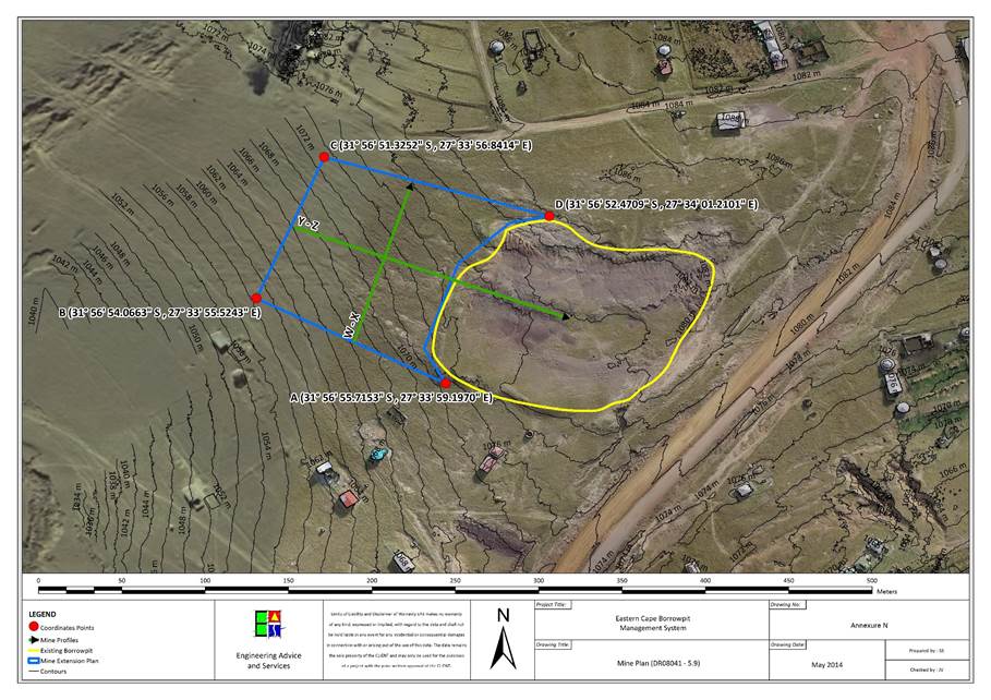
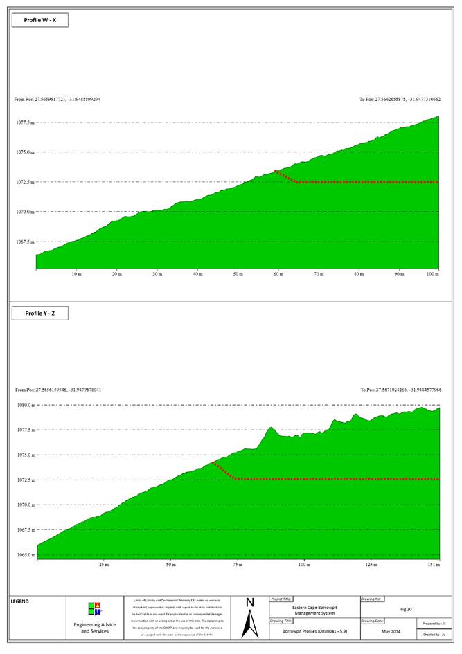
|
Contact Information
|
|
Contact
|
Name
|
Contact Number
|
|
Landowner
|
Communal
land
|
|
|
Ward
Councillor
|
Dudu
Kaspile
|
072
9758 832
|
|
Municipal
Manager
|
Cllr.
Z Shasha
|
047 874
0010
|
|
Location Details
|
|
GPS Position:
|
S31 53 37.2 , E27 32 04.3
|
|
Topography:
|
Gentle
southern slope.
|
|
Distance from Road:
|
40m
|
|
Physical Details
|
|
Access
|
No
access road.
|
|
Fencing
|
None.
|
|
Borrow Pit Extent
|
140m
x 140m
|
|
Proposed Mining Direction
|
East
|
|
Material Availability
|
50 000m3
|
|
Material Type
|
Mudstone,
sandstone
|
|
Data Collection
|
Residual
outcrop
|
|
Sample Collection and Tests Performed
|
|
Mudstone
|
2x
(Particle size distribution, Atterberg Limits, Modified California Bearing
Ratio)
|
|
Sandstone
|
Particle
size distribution, Atterberg Limits, Modified California Bearing Ratio, LA
Abrasion test, Wet and Dry Weathering Test.
|
|
Biophysical Environmental
Description
|
|
Vegetation and Status
|
Drakensberg Foothill Moist Grassland
|
|
Present Land Use
|
Natural
|
|
CBA
|
|
|
Land Use Type
|
Communal
|
|
Agricultural features
|
None
|
|
Alien invasive species
|
None
|
|
Potential Faunal Habitat:
|
Grassland
|
|
Natural Drainage and Erosion
|
The soil is moderately well drained. There is a major erosion
line 50m west of the quarry.
|
|
Rivers and Drainage Lines
|
Runoff collects in erosion lanes 50m east of the quarry and
across the road, south of the quarry.
|
|
Wetlands
|
None
|
|
Quaternary Catchment
|
S50F
|
|
Social Environment Description
|
|
Heritage
|
None
affected
|
|
Palaeontology
|
None
in Dolerite, Mudstones and Sandstones may have fossils
|
|
Archaeology
|
None
observed
|
|
Buildings and
Structures
|
Ruins in vicinity
|
|
Issus raised by I &
AP’s
|
Refer to section
|
Borrow Pit DR08041/14.4
|
Impact Assessment Mitigation
|
|
Issue
|
Description
|
Recommendation
|
|
Visual Exposure:
|
Visual
exposure of the quarry could increase because of the removal of vegetation
and the contract the quarry will create against the flat landscape.
|
Do
not remove vegetation or topsoil unnecessarily.
|
|
Natural Drainage and wetlands:
|
The
natural drainage of the area around the quarry could be affected of mining is
extended west, towards the erosion channel.
|
Keep
the quarry base as flat as possible to encourage even drainage.
|
|
Buildings:
|
None.
|
None.
|
|
Overhead Services:
|
It
would be dangerous to work too close to electricity lines towards the
north-east of the quarry.
|
Keep
30m clear of the electricity line.
|
|
Underground Services:
|
None.
|
None.
|
|
Fences:
|
None.
|
None.
|
|
Vegetation
|
|
|
|
Fauna
|
|
|
|
Agricultural features
|
None.
|
None.
|
|
Grazing
|
None.
|
None.
|
|
Mining Plan Details
|
|
Proposed mining direction:
|
Expand
quarry east until too close to the electricity line, then expand north if
more material in needed.
|
|
Area to be mined
|
|
|
Projected volume
|
|
|
Access road
|
An
access road will be constructed.
|
|
|
|
|
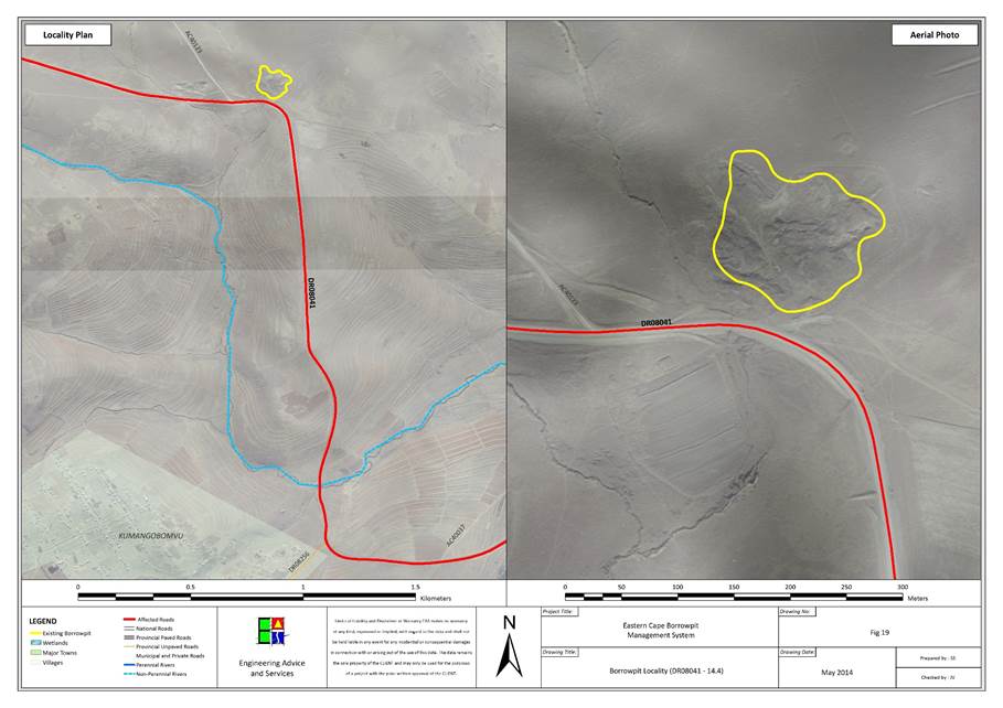
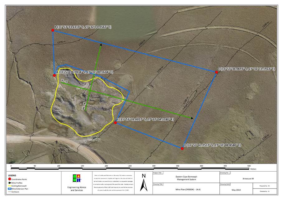
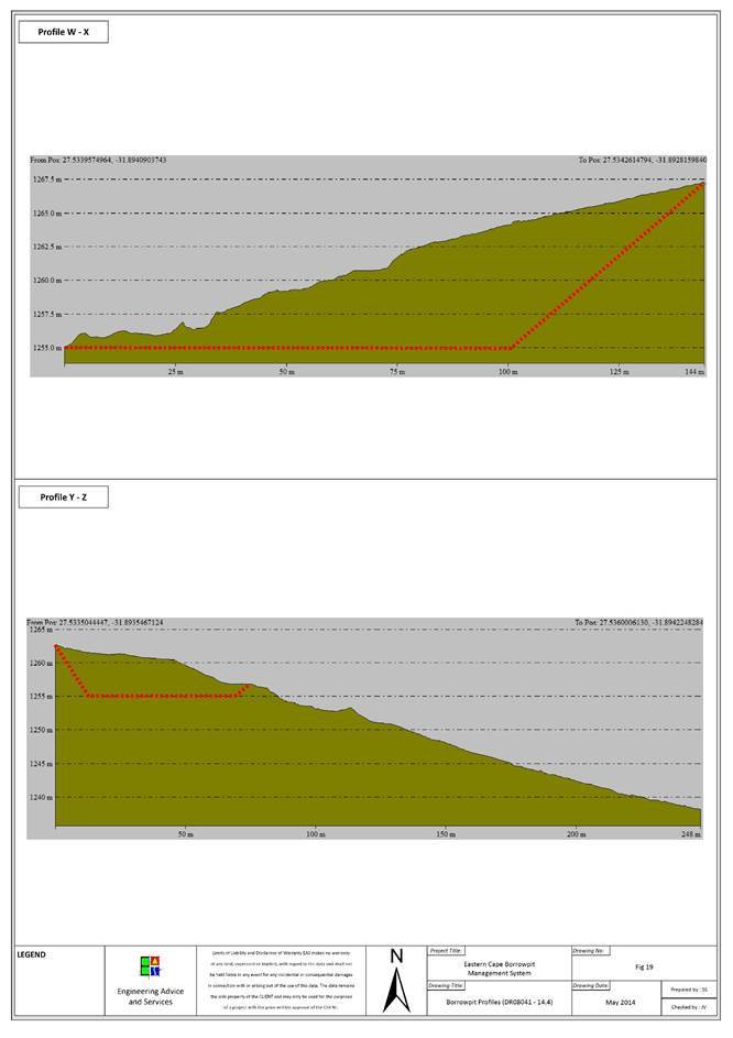
|
Contact Information
|
|
Contact
|
Name
|
Contact Number
|
|
Landowner
|
Communal
land
|
|
|
Ward
Councillor
|
Zukiswa
Qayiya
|
082 838
0549
|
|
Municipal
Manager
|
Cllr.
Z Shasha
|
047 874
0010
|
|
Location Details
|
|
GPS Position:
|
S31 47 39.8 , E27 27 35.4
|
|
Topography:
|
Moderately
steep eastern slope.
|
|
Distance from Road:
|
400m
|
|
Physical Details
|
|
Access:
|
400m
access road in very poor condition.
|
|
Fencing:
|
None.
|
|
Borrow Pit Extent:
|
180m
x 100m
|
|
Proposed Mining Direction:
|
North-west.
|
|
Material Availability:
|
30 000m3
|
|
Material Type:
|
Mudstone,
sandstone
|
|
Data Collection:
|
Residual
outcrop
|
|
Sample Collection and Tests Performed
|
|
Mudstone
|
2x
(Particle size distribution, Atterberg Limits, Modified California Bearing
Ratio)
|
|
Sandstone
|
Particle
size distribution, Atterberg Limits, Modified California Bearing Ratio, LA
Abrasion test, Wet and Dry Weathering Test.
|
|
Biophysical Environmental Description
|
|
Vegetation and Status
|
Tsomo Grassland
|
|
Present Land Use
|
Natural
|
|
CBA
|
CBA 3
|
|
Land Use Type
|
Communal
|
|
Agricultural features
|
Cultivated and Degraded
|
|
Alien invasive species
|
None
|
|
Potential Faunal Habitat:
|
Rocky habitat
|
|
Natural Drainage and Erosion
|
The soil is somewhat poorly drained, with deep pools collecting
in the quarry base.
|
|
Rivers and Drainage Lines
|
There is a major eroded drainage line running from east to west,
220m north of the quarry.
|
|
Wetlands
|
None
|
|
Quaternary Catchment
|
S20C
|
|
Social Environment Description
|
|
Heritage :
|
None
affected
|
|
Palaeontology:
|
None
in Dolerite, Mudstones and Sandstones may have fossils
|
|
Archaeology:
|
None
observed
|
|
Buildings and
Structures
|
Buildings in vicinity
|
|
Issus raised by I &
AP’s
|
Refer to section
|
Borrow Pit DR08041/28.8
|
Impact Assessment Mitigation
|
|
Issue
|
Description
|
Recommendation
|
|
Visual Exposure:
|
The
quarry is slightly visible from the road.
|
Bench
the steep quarry faces in the quarry.
|
|
Natural Drainage and wetlands:
|
Pooled
water in the quarry could become too deep and become a danger.
|
Ensure
water pools in the quarry base are not deeper than a meter.
|
|
Buildings:
|
None.
|
None.
|
|
Overhead Services:
|
None.
|
None.
|
|
Underground Services:
|
None.
|
None.
|
|
Fences:
|
None.
|
None.
|
|
Vegetation
|
|
|
|
Fauna
|
|
|
|
Agricultural features
|
None.
|
None.
|
|
Grazing
|
None.
|
None.
|
|
Mining Plan Details
|
|
Proposed mining direction:
|
North
|
|
Area to be mined:
|
|
|
Projected volume:
|
|
|
Access road:
|
Access
road will be rehabilitated.
|
|
|
|
|
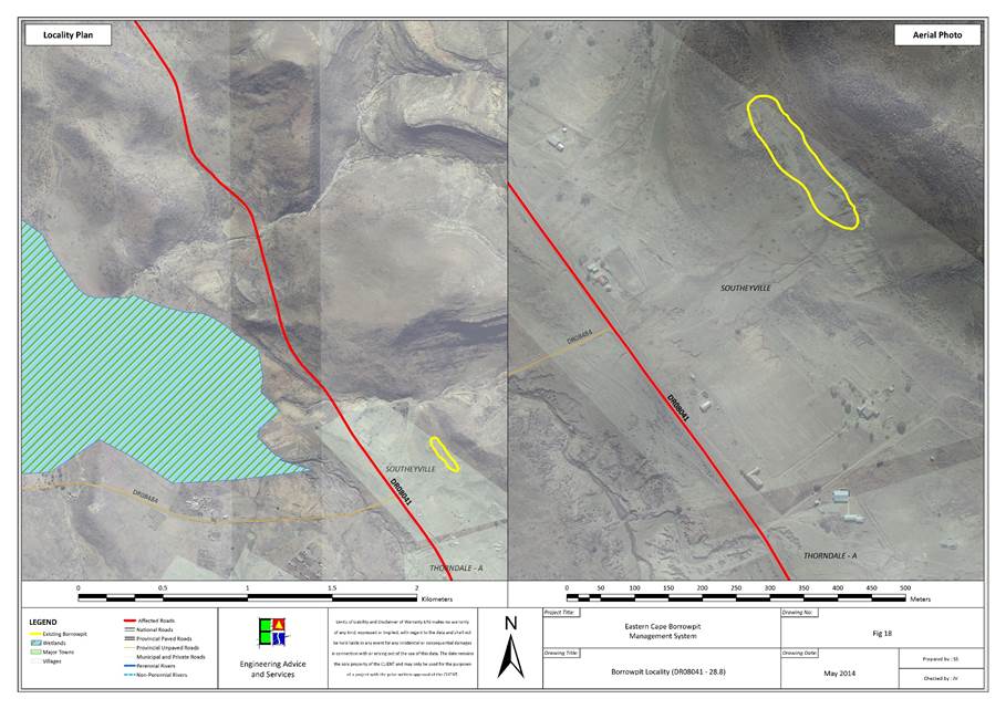
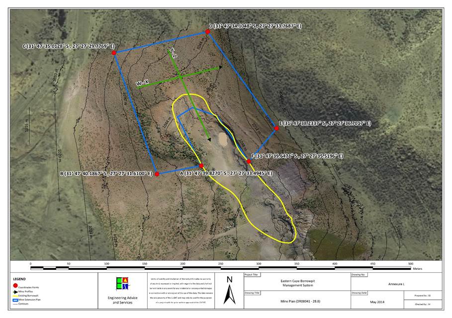
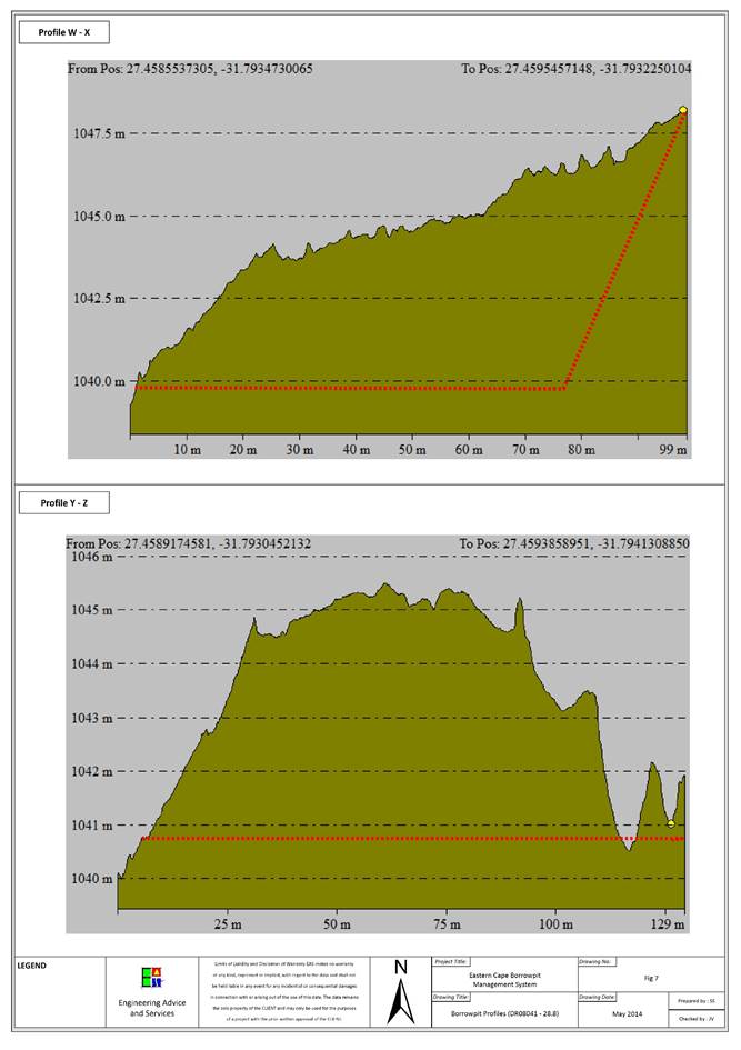
|
Contact Information
|
|
Contact
|
Name
|
Contact Number
|
|
Landowner
|
Communal
land
|
|
|
Ward
Councillor
|
Zukiswa
Qayiya
|
082 838
0549
|
|
Municipal
Manager
|
Cllr.
Z Shasha
|
047 874
0010
|
|
Location Details
|
|
GPS Position:
|
S31 44 59.6 , E27 26 33.3
|
|
Topography:
|
Very
gentle south-western slope.
|
|
Distance from Road:
|
50m
|
|
Physical Details
|
|
Access:
|
No
access road.
|
|
Fencing:
|
None.
|
|
Borrow Pit Extent:
|
60m
x 30m
|
|
Proposed Mining Direction:
|
North.
|
|
Material Availability:
|
40 000m3
|
|
Material Type:
|
Dolerite,
Sandstone
|
|
Data Collection:
|
Residual
outcrop
|
|
Sample Collection and Tests Performed
|
|
Dolerite
|
2x
(Particle size distribution, Atterberg Limits, Modified California Bearing
Ratio) + LA Abrasion test, Wet and Dry Weathering Test.
|
|
Sandstone
|
Particle
size distribution, Atterberg Limits, Modified California Bearing Ratio.
|
|
Biophysical Environmental Description
|
|
Vegetation and Status
|
Tsomo Grassland
|
|
Present Land Use
|
Natural
|
|
CBA
|
CBA 3
|
|
Land Use Type
|
Communal
|
|
Agricultural features
|
None
|
|
Alien invasive species
|
None
|
|
Potential Faunal Habitat:
|
Rocky habitat
|
|
Natural Drainage and Erosion
|
The soil is well drained.
|
|
Rivers and Drainage Lines
|
There is a major erosion channel 200m to the south, running from
east to west.
|
|
Wetlands
|
None
|
|
Quaternary Catchment
|
S20C
|
|
Social Environment Description
|
|
Heritage
|
None
affected
|
|
Palaeontology
|
None
in Dolerite, Mudstones and Sandstones may have fossils
|
|
Archaeology
|
None
observed
|
|
Buildings and
Structures
|
There is a small village 200 m East of the site
|
|
Issus raised by I &
AP’s
|
Refer to section
|
Borrow Pit DR08041/35.7
|
Impact Assessment Mitigation
|
|
Issue
|
Description
|
Recommendation
|
|
Visual Exposure:
|
The
quarry faces are not high and the landscape is relatively flat. Creating high
quarry faces would impact the area visually.
|
|
|
Natural Drainage and wetlands:
|
Variation
in slope of the quarry floor and the surrounding general area could encourage
erosion.
|
Keep
the slope of the quarry floor as close as possible to the slope of the
general area.
|
|
Buildings:
|
None.
|
None.
|
|
Overhead Services:
|
None.
|
None.
|
|
Underground Services:
|
None.
|
None.
|
|
Fences:
|
None.
|
None.
|
|
Vegetation
|
|
|
|
Fauna
|
|
|
|
Agricultural features
|
None.
|
None.
|
|
Grazing
|
None.
|
None.
|
|
Mining Plan Details
|
|
Proposed mining direction:
|
North.
|
|
Area to be mined
|
3727m2
|
|
Projected volume
|
|
|
Access road
|
An
access road will be created into the quarry.
|
|
|
|
|
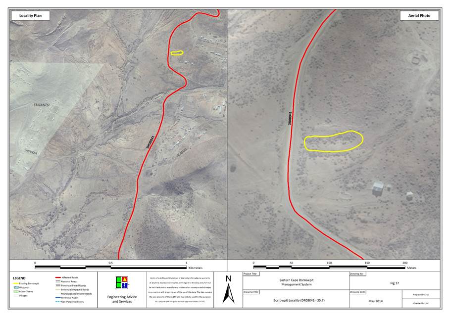
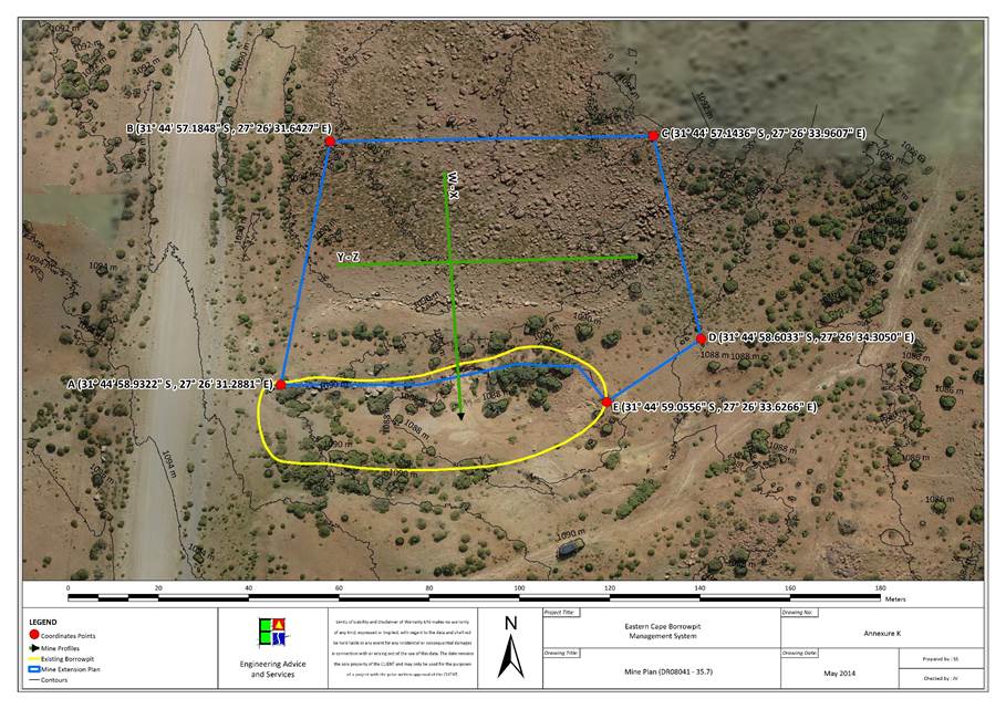
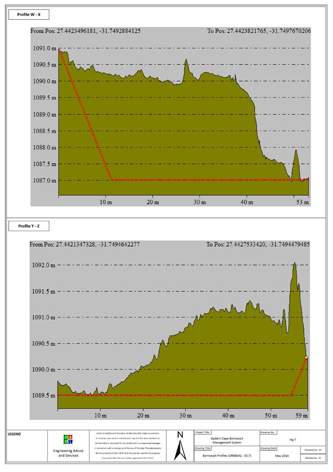
|
Contact Information
|
|
Contact
|
Name
|
Contact Number
|
|
Landowner
|
Communal
land
|
|
|
Ward
Councillor
|
Zukiswa
Qayiya
|
082 838
0549
|
|
Municipal
Manager
|
Cllr.
Z Shasha
|
047 874
0010
|
|
Location Details
|
|
GPS Position:
|
S31 44 08.4 , E27 26 44.1
|
|
Topography:
|
Flat
landscape.
|
|
Distance from Road:
|
30m
|
|
Physical Details
|
|
Access:
|
Adequate
access road.
|
|
Fencing:
|
None.
|
|
Borrow Pit Extent:
|
200m
x 70m
|
|
Proposed Mining Direction:
|
South
|
|
Material Availability:
|
50 000m3
|
|
Material Type:
|
Dolerite
|
|
Data Collection:
|
Residual
outcrop
|
|
Sample Collection and Tests Performed
|
|
Dolerite
|
3x
(Particle size distribution, Atterberg Limits, Modified California Bearing
Ratio) + LA Abrasion test, Wet and Dry Weathering Test.
|
|
Biophysical Environmental
Description
|
|
Vegetation and Status
|
Tsomo Grassland
|
|
Present Land Use
|
Natural
|
|
CBA
|
CBA 3
|
|
Land Use Type
|
Communal
|
|
Agricultural features
|
None
|
|
Alien invasive species
|
None
|
|
Potential Faunal Habitat:
|
Grassland
|
|
Natural Drainage and Erosion
|
Poor drainage. Slow sheetwash with bulk of water draining into
the ground.
|
|
Rivers and Drainage Lines
|
None
|
|
Wetlands
|
None
|
|
Quaternary Catchment
|
S20C
|
|
Social Environment Description
|
|
Heritage
|
None
affected
|
|
Palaeontology
|
None
in Dolerite, Mudstones and Sandstones may have fossils
|
|
Archaeology
|
None
observed
|
|
Buildings and
Structures
|
Buildings in vicinity
|
|
Issus raised by I &
AP’s
|
Refer to section
|
Borrow Pit DR08041/37.7
|
Impact Assessment Mitigation
|
|
Issue
|
Description
|
Recommendation
|
|
Visual Exposure:
|
High
quarry faces and deepening the quarry should be avoided because of the
contrast it will create between the quarry and the environment.
|
Keep
the quarry face as small as possible to blend in with the flat environment as
much as possible.
|
|
Natural Drainage and wetlands:
|
None.
|
None.
|
|
Buildings:
|
The
quarry could expand too close (30m) to the nearby houses.
|
Avoid
expanding the quarry in the direction of the buildings (North-east).
|
|
Overhead Services:
|
None.
|
None.
|
|
Underground Services:
|
None.
|
None.
|
|
Fences:
|
None.
|
None.
|
|
Vegetation
|
|
|
|
Fauna
|
|
|
|
Agricultural features
|
None.
|
None.
|
|
Grazing
|
None.
|
None.
|
|
Mining Plan Details
|
|
Proposed mining direction:
|
South
|
|
Area to be mined
|
17496m2
|
|
Projected volume
|
|
|
Access road
|
Adequate
existing access road.
|
|
|
|
|
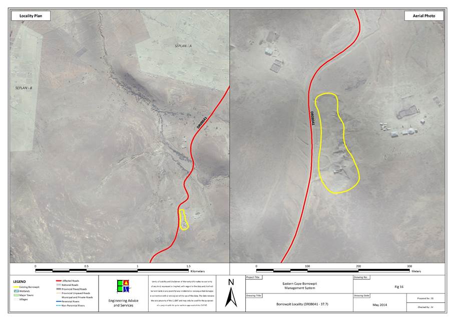
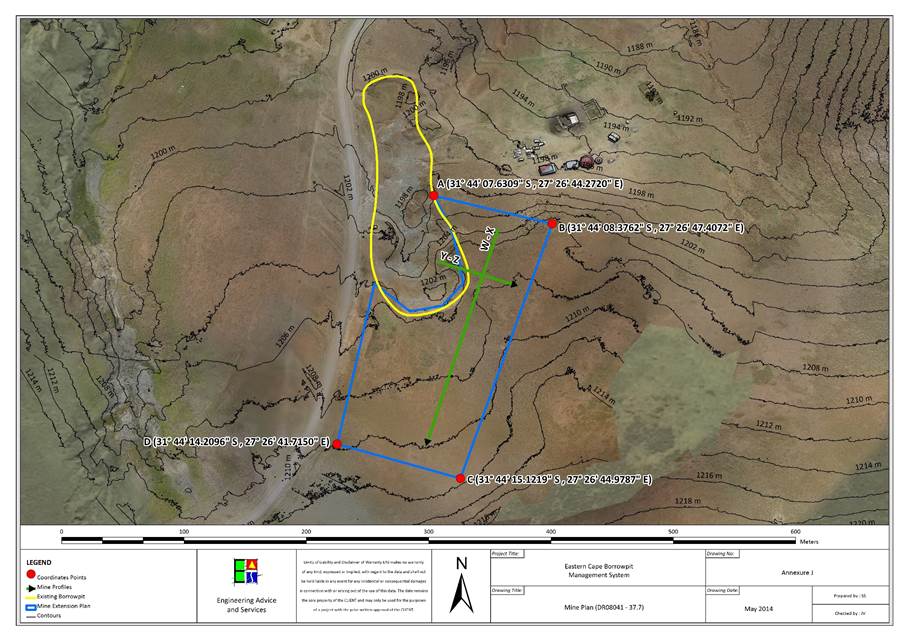
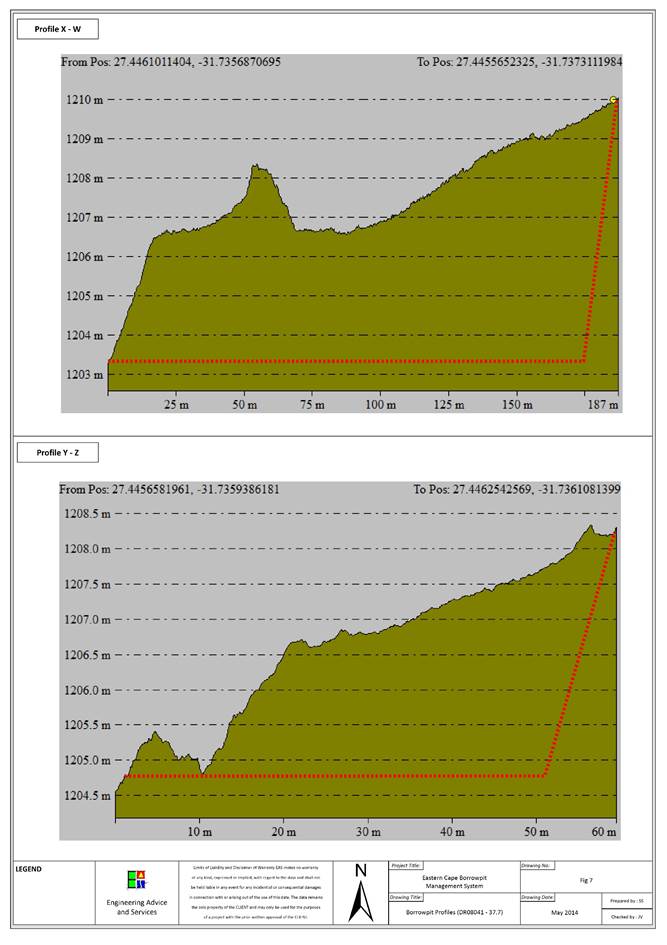
|
Contact Information
|
|
Contact
|
Name
|
Contact Number
|
|
Landowner
|
Communal
land
|
|
|
Ward
Councillor
|
Nozuko
Sygnoria Mafanya
|
073 555
3340
|
|
Municipal
Manager
|
Cllr.
Z Shasha
|
047 874
0010
|
|
Location Details
|
|
GPS Position:
|
S31 38 24.0 , E27 27 59.0
|
|
Topography:
|
Gentle
to moderate western slope.
|
|
Distance from Road:
|
20
m
|
|
Physical Details
|
|
Access:
|
There
is no access road to the quarry.
|
|
Fencing:
|
None.
|
|
Borrow Pit Extent:
|
40
m x 20
m
|
|
Proposed Mining Direction:
|
South
or north
|
|
Material Availability:
|
20 000 m3
|
|
Material Type:
|
Mudstone,
sandstone
|
|
Data Collection:
|
Residual
outcrop and stockpiles
|
|
Sample Collection and Tests Performed
|
|
Mudstone
|
2x
(Particle size distribution, Atterberg Limits, Modified California Bearing
Ratio) + LA Abrasion test, Wet and Dry Weathering Test.
|
|
Sandstone
|
Particle
size distribution, Atterberg Limits, Modified California Bearing Ratio, LA
Abrasion test, Wet and Dry Weathering Test.
|
|
Biophysical Environmental
Description
|
|
Vegetation and Status
|
Tsomo Grassland
|
|
Present Land Use
|
Natural
|
|
CBA
|
CBA 3
|
|
Land Use Type
|
Communal
|
|
Agricultural features
|
None
|
|
Alien invasive species
|
None
|
|
Potential Faunal Habitat:
|
Large Rocky Outcrop
|
|
Natural Drainage and Erosion
|
General sheetwash. No erosion.
|
|
Rivers and Drainage Lines
|
Present
|
|
Wetlands
|
None
|
|
Quaternary Catchment
|
S20C
|
|
Social Environment Description
|
|
Heritage
|
None
affected
|
|
Palaeontology
|
None
in Dolerite, Mudstones and Sandstones may have fossils
|
|
Archaeology
|
None
observed
|
|
Buildings and
Structures
|
Scattered houses around the site
|
|
Issus raised by I &
AP’s
|
Refer to section
|
Borrow Pit DR08041/50.1
|
Impact Assessment Mitigation
|
|
Issue
|
Description
|
Recommendation
|
|
Visual Exposure:
|
Quarry
extension will have a visual impact on the areas because of the contract
between the baron quarry and the surrounding vegetation.
|
The
mining scar should be rehabilitated by replacing topsoil over the mining area
after the quarry is used because of the proximity to local houses.
|
|
Natural Drainage and wetlands:
|
None.
|
Avoid
steep slopes when mining which leads to concentrated water flows and erosion.
|
|
Buildings:
|
Quarry
will move too close to the surrounding houses if the proposed mining
footprint is not mitigated.
|
Keep
a distance of 30 m from houses.
|
|
Overhead Services:
|
There
is an overhead telephone line running north-east to south-west approximately 60
m north of the quarry. Keep at least 30
m clear of the overhead poles.
|
Keep
a distance of 30 m from overheads.
|
|
Underground Services:
|
None.
|
None.
|
|
Fences:
|
There
are fences surrounding house yards 60m on either side of the quarry (north
and south), which should be stayed 30m clear of in terms of quarry expansion.
|
None.
|
|
Vegetation
|
|
|
|
Fauna
|
|
|
|
Agricultural features
|
|
None.
|
|
Grazing
|
Informal
grazing will be impacted.
|
None.
|
|
Mining Plan Details
|
|
Proposed mining direction:
|
North,
south and east (limited by houses and overheads).
|
|
Area to be mined:
|
6432m2
|
|
Projected volume:
|
|
|
Access road:
|
A
short access road of approximately 30m should be constructed for the use of
construction vehicles.
|
|
|
|
|
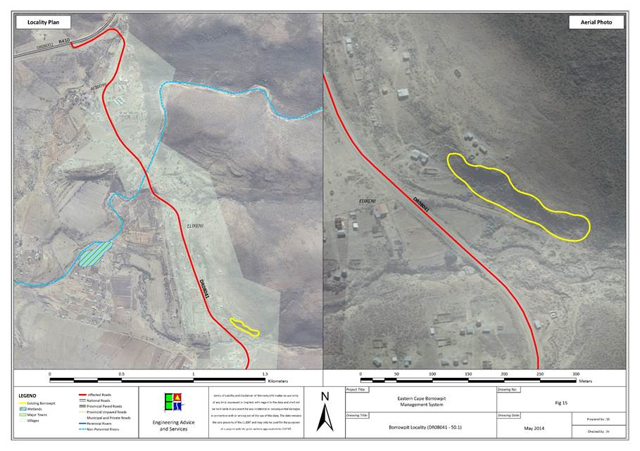
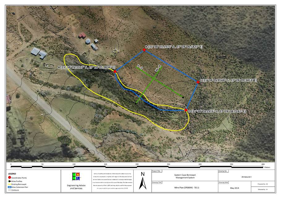
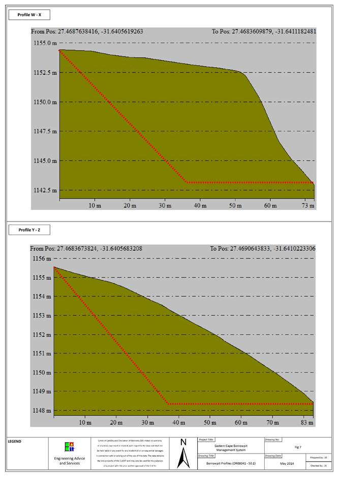
|
Contact Information
|
|
Contact
|
Name
|
Contact Number
|
|
Landowner
|
Communal
land
|
|
|
Ward
Councillor
|
Noloyiso
Mto
|
083 591
9238
|
|
Municipal
Manager
|
Cllr.
Z Shasha
|
047 874
0010
|
|
Location Details
|
|
GPS Position:
|
S31 49 59.366 , E27 43 33.517
|
|
Topography:
|
Gentle
eastern slope.
|
|
Distance from Road:
|
20m
|
|
Physical Details
|
|
Access:
|
No
access road. Quarry situated next to road.
|
|
Fencing:
|
None.
|
|
Borrow Pit Extent:
|
50m
x 40m
|
|
Proposed Mining Direction:
|
South
|
|
Material Availability:
|
30 000m3
|
|
Material Type:
|
Dolerite
|
|
Data Collection:
|
Residual
outcrop
|
|
Sample Collection and Tests Performed
|
|
Dolerite
|
3x
(Particle size distribution, Atterberg Limits, Modified California Bearing
Ratio) + LA Abrasion test, Wet and Dry Weathering Test.
|
|
Biophysical Environmental
Description
|
|
Vegetation and Status
|
Tsomo Grassland
|
|
Present Land Use
|
Natural
|
|
CBA
|
CBA 3
|
|
Land Use Type
|
Communal
|
|
Agricultural features
|
Cultivated and Degraded
|
|
Alien invasive species
|
None
|
|
Potential Faunal Habitat:
|
Grassland
|
|
Natural Drainage and Erosion
|
General sheetwash forming shallow depressions in the ground
which flows into the larger river to the east of the quarry.
|
|
Rivers and Drainage Lines
|
There is a big river 350m to the east of the quarry
|
|
Wetlands
|
None
|
|
Quaternary Catchment
|
S50G
|
|
Social Environment Description
|
|
Heritage
|
None
affected
|
|
Palaeontology
|
None
in Dolerite, Mudstones and Sandstones may have fossils
|
|
Archaeology
|
None
observed
|
|
Buildings and
Structures
|
None
|
|
Issus raised by I &
AP’s
|
Refer to section
|
Borrow Pit DR08247/2.5
|
Impact Assessment Mitigation
|
|
Issue
|
Description
|
Recommendation
|
|
Visual Exposure:
|
Grasslands
will be removed when quarry is extended.
|
Replace
topsoil on the worked areas of the quarry after use if it is known that is
will not be expanded in that direction again.
|
|
Natural Drainage and wetlands:
|
Formation
of erosion channels caused by removal of topsoil and vegetation.
|
Avoid
creating steep slopes and excavating too deep, creating structural damage to
the ground.
|
|
Buildings:
|
None.
|
None.
|
|
Overhead Services:
|
Excavation
could become dangerous if the quarry is worked too close to the overhead
services approximately 20m east of the quarry.
|
Do
not mine east so to keep clear of the overhead services.
|
|
Underground Services:
|
None.
|
None.
|
|
Fences:
|
None.
|
None.
|
|
Vegetation
|
|
|
|
Fauna
|
|
|
|
Agricultural features
|
None.
|
None.
|
|
Grazing
|
None.
|
None.
|
|
Mining Plan Details
|
|
Proposed mining direction:
|
South.
|
|
Area to be mined
|
|
|
Projected volume
|
|
|
Access road
|
None.
|
|
|
|
|
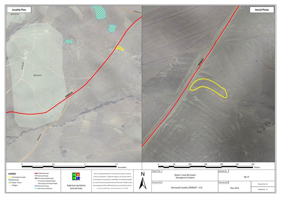
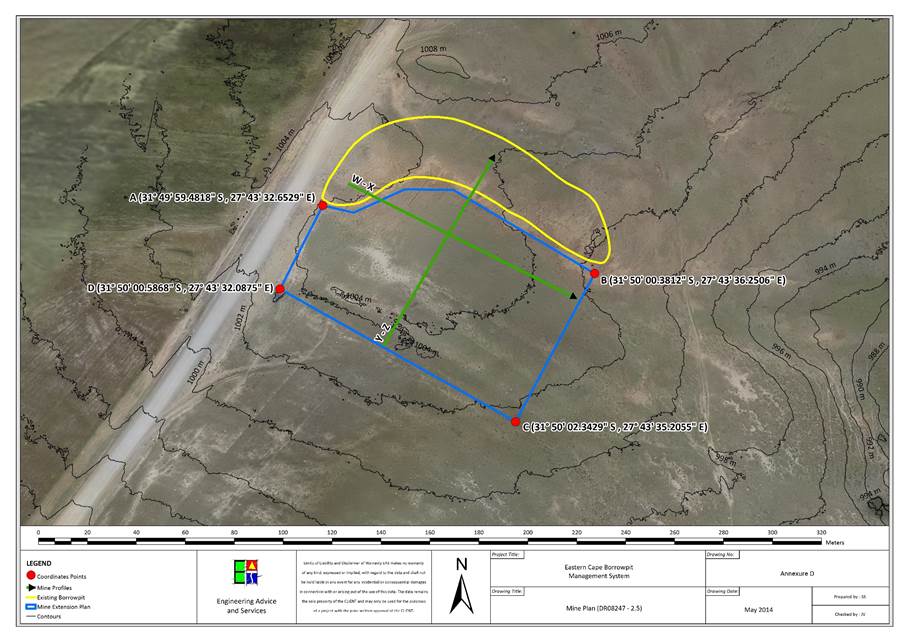
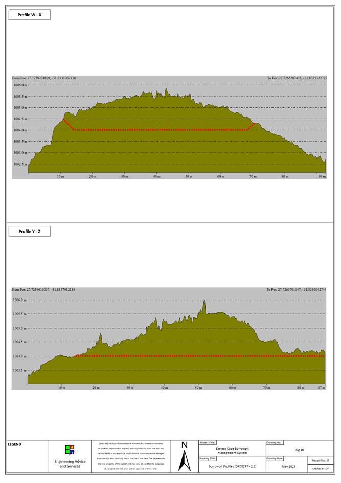
|
Contact Information
|
|
Contact
|
Name
|
Contact Number
|
|
Landowner
|
Communal
land
|
|
|
Ward
Councillor
|
Noloyiso
Mto
|
083 591
9238
|
|
Municipal
Manager
|
Cllr.
Z Shasha
|
047 874
0010
|
|
Location Details
|
|
GPS Position:
|
S31 51 39.678 , E27 41 3.320
|
|
Topography:
|
The
quarry is situated on the edge a ridge which drops of to the south of the
quarry.
|
|
Distance from Road:
|
15m
|
|
Physical Details
|
|
Access:
|
There
is adequate access to the quarry.
|
|
Fencing:
|
None.
|
|
Borrow Pit Extent:
|
200m
x 50m
|
|
Proposed Mining Direction:
|
West
|
|
Material Availability:
|
20 000m3
|
|
Material Type:
|
Mudstone,
sandstone
|
|
Data Collection:
|
Residual
outcrop.
|
|
Sample Collection and Tests Performed
|
|
Mudstone
|
Particle
size distribution, Atterberg Limits, Modified California Bearing Ratio, LA
Abrasion test, Wet and Dry Weathering Test.
|
|
Sandstone
|
2x
(Particle size distribution, Atterberg Limits, Modified California Bearing
Ratio)
|
|
Biophysical Environmental Description
|
|
Vegetation and Status
|
Southern Mistbelt Forest
|
|
Present Land Use
|
Natural
|
|
CBA
|
CBA 1
|
|
Land Use Type
|
Communal
|
|
Agricultural features
|
None
|
|
Alien invasive species
|
None
|
|
Potential Faunal Habitat:
|
Forest/Rocky
|
|
Natural Drainage and Erosion
|
Water drains south down the face of the ridge, collection in
drainage channels in the topography.
|
|
Rivers and Drainage Lines
|
Runoff collects at the bottom of the ridge in larger drainage
channels.
|
|
Wetlands
|
None
|
|
Quaternary Catchment
|
S50G
|
|
Social Environment Description
|
|
Heritage
|
None
affected
|
|
Palaeontology
|
None
in Dolerite, Mudstones and Sandstones may have fossils
|
|
Archaeology
|
None
observed
|
|
Buildings and
Structures
|
None
|
|
Issus raised by I &
AP’s
|
Refer to section
|
Borrow Pit DR08247/8.5
|
Impact Assessment Mitigation
|
|
Issue
|
Description
|
Recommendation
|
|
Visual Exposure:
|
The
quarry will become more visible from the road once expanded.
|
Replace
topsoil on areas in the quarry which will not be used in the future.
|
|
Natural Drainage and wetlands:
|
Mining
over the edge of the ridge will cause an unstable slope which will encourage
erosion channels to form on the steep slope.
|
Water
will drain sideways, along the road out of the quarry because of the berms to
be kept against the quarry edge.
|
|
Buildings:
|
None.
|
None.
|
|
Overhead Services:
|
None.
|
None.
|
|
Underground Services:
|
None.
|
None.
|
|
Fences:
|
None.
|
None.
|
|
Vegetation
|
|
|
|
Fauna
|
|
|
|
Agricultural features
|
None.
|
None.
|
|
Grazing
|
None.
|
None.
|
|
Mining Plan Details
|
|
Proposed mining direction:
|
West,
along the ridge edge.
|
|
Area to be mined
|
|
|
Projected volume
|
|
|
Access road
|
None.
|
|
|
|
|
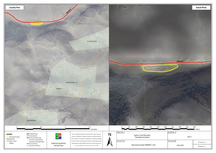
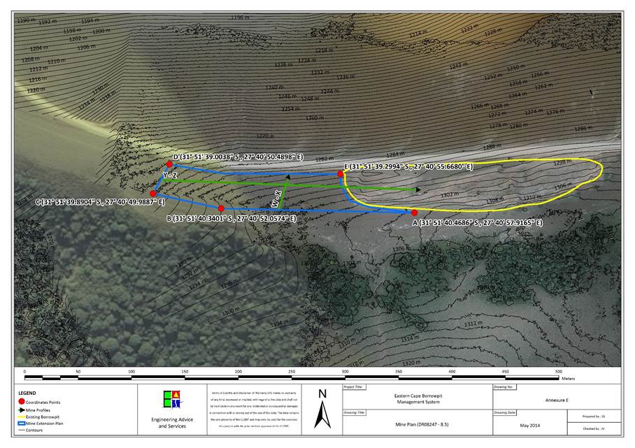
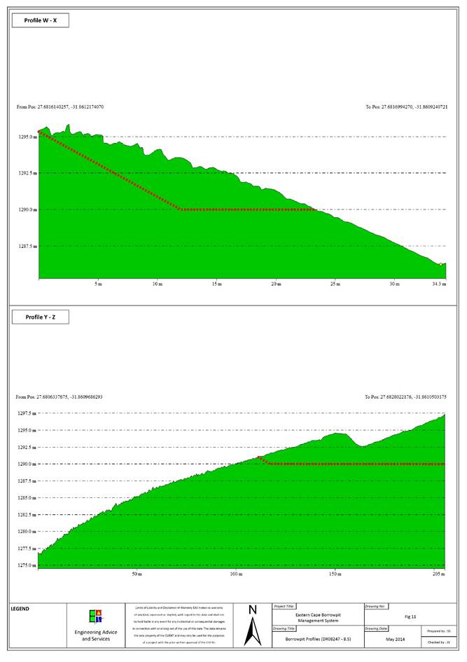
|
Contact Information
|
|
Contact
|
Name
|
Contact Number
|
|
Landowner
|
Communal
land
|
|
|
Ward
Councillor
|
Noloyiso
Mto
|
083 591
9238
|
|
Municipal
Manager
|
Cllr.
Z Shasha
|
047 874
0010
|
|
Location Details
|
|
GPS Position:
|
S31 54 09.0 , E27 36 40.5
|
|
Topography:
|
Flat
to gentle slope.
|
|
Distance from Road:
|
55m
|
|
Physical Details
|
|
Access:
|
No
access road. There is also a fence along the road without a gate.
|
|
Fencing:
|
There
is a fence along the road. No gate.
|
|
Borrow Pit Extent:
|
130m
x 100m
|
|
Proposed Mining Direction:
|
South-west,
along the road.
|
|
Material Availability:
|
50 000m3
|
|
Material Type:
|
Mudstone,
sandstone, dolerite
|
|
Data Collection:
|
Residual
outcrop
|
|
Sample Collection and Tests Performed
|
|
Mudstone
|
Particle
size distribution, Atterberg Limits, Modified California Bearing Ratio, LA
Abrasion test, Wet and Dry Weathering Test.
|
|
Sandstone
|
Particle
size distribution, Atterberg Limits, Modified California Bearing Ratio.
|
|
Dolerite
|
Particle
size distribution, Atterberg Limits, Modified California Bearing Ratio.
|
|
Biophysical Environmental
Description
|
|
Vegetation and Status
|
Tsomo Grassland
|
|
Present Land Use
|
Urban Built-up
|
|
CBA
|
CBA 3
|
|
Land Use Type
|
Communal
|
|
Agricultural features
|
Cultivated and Degraded
|
|
Alien invasive species
|
None
|
|
Potential Faunal Habitat:
|
Grassland
|
|
Natural Drainage and Erosion
|
Slow sheetwash off a relatively flat environment. Water collects
in the quarry forming shallow pools which slowly drain into the ground.
|
|
Rivers and Drainage Lines
|
None
|
|
Wetlands
|
Dam
|
|
Quaternary Catchment
|
S50G
|
|
Social Environment Description
|
|
Heritage
|
None
affected
|
|
Palaeontology
|
None
in Dolerite, Mudstones and Sandstones may have fossils
|
|
Archaeology
|
None
observed
|
|
Buildings and
Structures
|
Houses
70m north-west of the quarry, across the road are existing houses forming a
small settlement.
|
|
Issus raised by I &
AP’s
|
Refer
to section
|
Borrow Pit DR08247/19.1
|
Impact Assessment Mitigation
|
|
Issue
|
Description
|
Recommendation
|
|
Visual Exposure:
|
The
visual impact of the quarry could increase because of the thick grass growth
around the quarry which creates a strong contrast with the baron quarry.
|
Place
topsoil in a stockpile and cover the worked areas of the quarry with it after
the quarry has been used. Cover only quarry faces which are not to be used in
the future.
|
|
Natural Drainage and wetlands:
|
None.
|
None.
|
|
Buildings:
|
None.
|
None.
|
|
Overhead Services:
|
None.
|
None.
|
|
Underground Services:
|
None.
|
None.
|
|
Fences:
|
Fences
might be damaged when moved to gain access to the quarry.
|
Fences
which are removed in order to gain access to the quarry are to be fixed when
quarry use is completed. Alternatively a gate could be installed in the
fence.
|
|
Vegetation
|
|
|
|
Fauna
|
|
|
|
Agricultural features
|
None.
|
None.
|
|
Grazing
|
None.
|
None.
|
|
Mining Plan Details
|
|
Proposed mining direction:
|
South-west
|
|
Area to be mined
|
|
|
Projected volume
|
|
|
Access road
|
An
access road should be constructed for the use of construction vehicles.
|
|
|
|
|
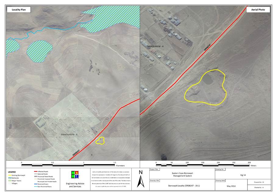
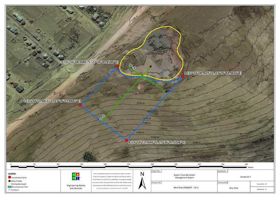
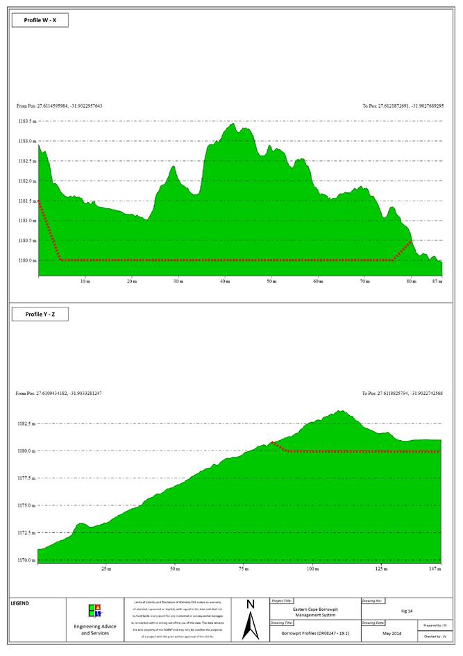
|
Contact Information
|
|
Contact
|
Name
|
Contact Number
|
|
Landowner
|
Communal
land
|
|
|
Ward
Councillor
|
Albertinah
Nokwetu Rotyi
|
072 084
8022
|
|
Municipal
Manager
|
Cllr.
Z Shasha
|
047 874
0010
|
|
Location Details
|
|
GPS Position:
|
S31 54 48.2 , E27 34 22.0
|
|
Topography:
|
Flat
plain
|
|
Distance from Road:
|
2m
|
|
Physical Details
|
|
Access:
|
Adequate
access road.
|
|
Fencing:
|
None.
|
|
Borrow Pit Extent:
|
100m
x 40m
|
|
Proposed Mining Direction:
|
West
|
|
Material Availability:
|
50 000m3
|
|
Material Type:
|
Dolerite,
mudstone
|
|
Data Collection:
|
Residual
outcrop and stockpiles
|
|
Sample Collection and Tests
Performed
|
|
Dolerite
|
Particle
size distribution, Atterberg Limits, Modified California Bearing Ratio, LA
Abrasion test, Wet and Dry Weathering Test.
|
|
Mudstone
|
2x
(Particle size distribution, Atterberg Limits, Modified California Bearing
Ratio)
|
|
Biophysical Environmental
Description
|
|
Vegetation and Status
|
0
|
|
Present Land Use
|
Natural
|
|
CBA
|
CBA 3
|
|
Land Use Type
|
Communal
|
|
Agricultural features
|
Cultivated and Degraded
|
|
Alien invasive species
|
Scattered
|
|
Potential Faunal Habitat:
|
Grassland
|
|
Natural Drainage and Erosion
|
Water seeps into the ground or flows away slowly in the form of
controlled sheetwash.
|
|
Rivers and Drainage Lines
|
None
|
|
Wetlands
|
None
|
|
Quaternary Catchment
|
S50F
|
|
Social Environment Description
|
|
Heritage
|
None
affected
|
|
Palaeontology
|
None
in Dolerite, Mudstones and Sandstones may have fossils
|
|
Archaeology
|
None
observed
|
|
Buildings and
Structures
|
None
|
|
Issus raised by I &
AP’s
|
Refer to section
|
Borrow Pit DR08247/23.2
|
Impact Assessment Mitigation
|
|
Issue
|
Description
|
Recommendation
|
|
Visual Exposure:
|
The
quarry will become more visible from the road because of a treeline at the
edge of the quarry which will be removed.
|
Build
up the steep three meter slope against the road to at least a 1/3 slope to
correct the dangerous drop-off next to the road. Batter the future quarry
working face to a 1/3 slope as well.
|
|
Natural Drainage and wetlands:
|
None.
|
Avoid
deepening the quarry which will lead to drainage problems.
|
|
Buildings:
|
None.
|
None.
|
|
Overhead Services:
|
None.
|
None.
|
|
Underground Services:
|
None.
|
None.
|
|
Fences:
|
None.
|
None.
|
|
Vegetation
|
|
|
|
Fauna
|
|
|
|
Agricultural features
|
None.
|
None.
|
|
Grazing
|
None.
|
None.
|
|
Mining Plan Details
|
|
Proposed mining direction:
|
West
|
|
Area to be mined
|
|
|
Projected volume
|
|
|
Access road
|
Adequate
access road.
|
|
|
|
|
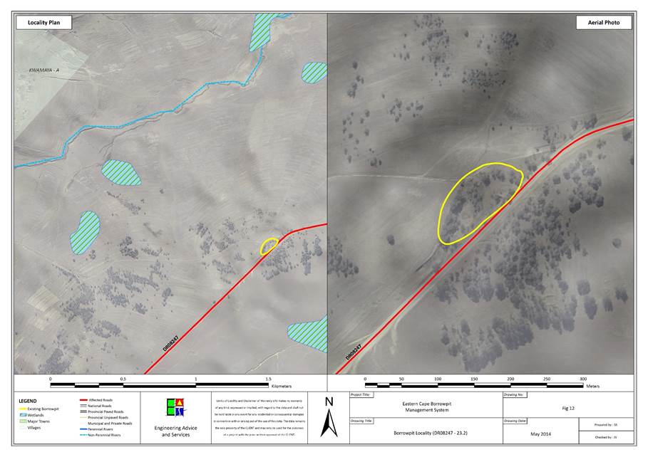
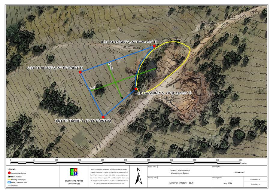
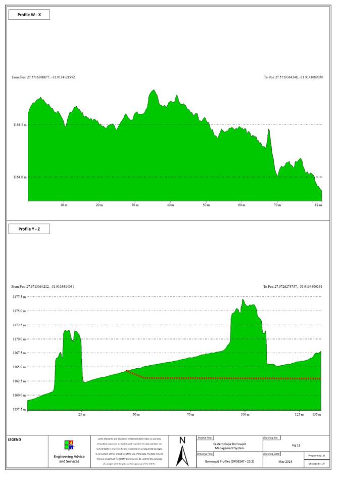
|
Contact Information
|
|
Contact
|
Name
|
Contact Number
|
|
Landowner
|
Communal
land
|
|
|
Ward
Councillor
|
Albertinah
Nokwetu Rotyi
|
072 084
8022
|
|
Municipal
Manager
|
Cllr.
Z Shasha
|
047 874
0010
|
|
Location Details
|
|
GPS Position:
|
S31 54 48.2 , E27 34 22.0
|
|
Topography:
|
Flat
plain
|
|
Distance from Road:
|
2m
|
|
Physical Details
|
|
Access:
|
Adequate
access road.
|
|
Fencing:
|
None.
|
|
Borrow Pit Extent:
|
100m
x 40m
|
|
Proposed Mining Direction:
|
West
|
|
Material Availability:
|
50 000m3
|
|
Material Type:
|
Dolerite,
mudstone
|
|
Data Collection:
|
Residual
outcrop and stockpiles
|
|
Sample Collection and Tests
Performed
|
|
Dolerite
|
Particle
size distribution, Atterberg Limits, Modified California Bearing Ratio, LA
Abrasion test, Wet and Dry Weathering Test.
|
|
Mudstone
|
2x
(Particle size distribution, Atterberg Limits, Modified California Bearing
Ratio)
|
|
Biophysical Environmental
Description
|
|
Vegetation and Status
|
0
|
|
Present Land Use
|
Natural
|
|
CBA
|
CBA 3
|
|
Land Use Type
|
Communal
|
|
Agricultural features
|
Cultivated and Degraded
|
|
Alien invasive species
|
Scattered
|
|
Potential Faunal Habitat:
|
Grassland
|
|
Natural Drainage and Erosion
|
Water seeps into the ground or flows away slowly in the form of
controlled sheetwash.
|
|
Rivers and Drainage Lines
|
None
|
|
Wetlands
|
None
|
|
Quaternary Catchment
|
S50F
|
|
Social Environment Description
|
|
Heritage
|
None
affected
|
|
Palaeontology
|
None
in Dolerite, Mudstones and Sandstones may have fossils
|
|
Archaeology
|
None
observed
|
|
Buildings and
Structures
|
None
|
|
Issus raised by I &
AP’s
|
Refer to section
|
Borrow Pit DR08247/Village
|
Impact Assessment Mitigation
|
|
Issue
|
Description
|
Recommendation
|
|
Visual Exposure:
|
The
quarry will become more visible from the road because of a treeline at the
edge of the quarry which will be removed.
|
Build
up the steep three meter slope against the road to at least a 1/3 slope to
correct the dangerous drop-off next to the road. Batter the future quarry
working face to a 1/3 slope as well.
|
|
Natural Drainage and wetlands:
|
None.
|
Avoid
deepening the quarry which will lead to drainage problems.
|
|
Buildings:
|
None.
|
None.
|
|
Overhead Services:
|
None.
|
None.
|
|
Underground Services:
|
None.
|
None.
|
|
Fences:
|
None.
|
None.
|
|
Vegetation
|
|
|
|
Fauna
|
|
|
|
Agricultural features
|
None.
|
None.
|
|
Grazing
|
None.
|
None.
|
|
Mining Plan Details
|
|
Proposed mining direction:
|
West
|
|
Area to be mined
|
|
|
Projected volume
|
|
|
Access road
|
Adequate
access road.
|
|
|
|
|
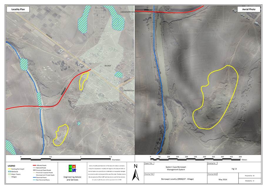
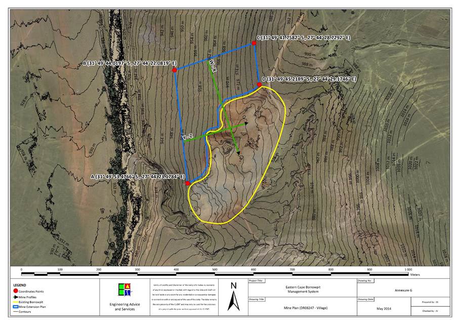
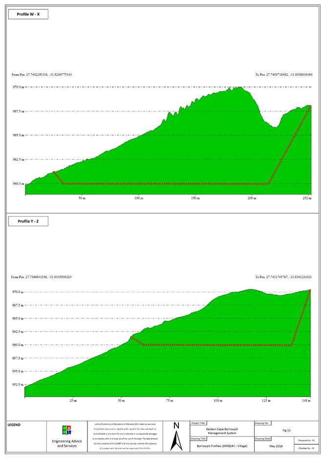
|
Contact Information
|
|
Contact
|
Name
|
Contact Number
|
|
Landowner
|
Communal
land
|
|
|
Ward
Councillor
|
Nolundi
Gertrude Futiso
|
073 331
7035
|
|
Municipal
Manager
|
Cllr.
Z Shasha
|
047 874
0010
|
|
Location Details
|
|
GPS Position:
|
S31 51 22.136 , E27 38 34.865
|
|
Topography:
|
Gentle
western slope.
|
|
Distance from Road:
|
10m
|
|
Physical Details
|
|
Access:
|
No
access road. Quarry is next to the road.
|
|
Fencing:
|
None.
|
|
Borrow Pit Extent:
|
180m
x 90m
|
|
Proposed Mining Direction:
|
North
or east
|
|
Material Availability:
|
40 000m3
|
|
Material Type:
|
Mudstone,
sandstone
|
|
Data Collection:
|
Residual
outcrop
|
|
Sample Collection and Tests
Performed
|
|
Sandstone
|
2x (Particle size distribution,
Atterberg Limits, Modified California Bearing Ratio)
|
|
Mudstone
|
Particle
size distribution, Atterberg Limits, Modified California Bearing Ratio, LA
Abrasion test, Wet and Dry Weathering Test.
|
|
Biophysical Environmental
Description
|
|
Vegetation and Status
|
Drakensberg Foothill Moist Grassland
|
|
Present Land Use
|
Natural
|
|
CBA
|
|
|
Land Use Type
|
Communal
|
|
Agricultural features
|
None
|
|
Alien invasive species
|
None
|
|
Potential Faunal Habitat:
|
Rocky habitat
|
|
Natural Drainage and Erosion
|
General sheetwash gathering in main eroded drainage channels.
|
|
Rivers and Drainage Lines
|
Runoff collects in an eroded drainage channel 100m west of the
quarry, across the road.
|
|
Wetlands
|
None
|
|
Quaternary Catchment
|
S50F
|
|
Social Environment Description
|
|
Heritage
|
None
affected
|
|
Palaeontology
|
None
in Dolerite, Mudstones and Sandstones may have fossils
|
|
Archaeology
|
None
observed
|
|
Buildings and
Structures
|
None
|
|
Issus raised by I &
AP’s
|
Refer to section
|
Borrow Pit DR08248/1.3
|
Impact Assessment Mitigation
|
|
Issue
|
Description
|
Recommendation
|
|
Visual Exposure:
|
Highly
visible from the road. Quarry extension could increase the visibility of the
quarry.
|
Batter
the quarry face to a 1/3 slope.
|
|
Natural Drainage and wetlands:
|
Loss
of vegetation due to the expansion of the quarry could lead to a less
controlled runoff and increased erosion if not managed.
|
Flatten
the quarry base or create a drainage basin to control runoff which could
cause erosion if not controlled.
|
|
Buildings:
|
None.
|
None.
|
|
Overhead Services:
|
None.
|
None.
|
|
Underground Services:
|
None.
|
None.
|
|
Fences:
|
None.
|
None.
|
|
Vegetation
|
|
|
|
Fauna
|
|
|
|
Agricultural features
|
|
|
|
Grazing
|
None.
|
None.
|
|
Mining Plan Details
|
|
Proposed mining direction:
|
South-east
and north-west
|
|
Area to be mined
|
|
|
Projected volume
|
|
|
Access road
|
No
access road. The quarry is situated next to the road.
|
|
|
|
|
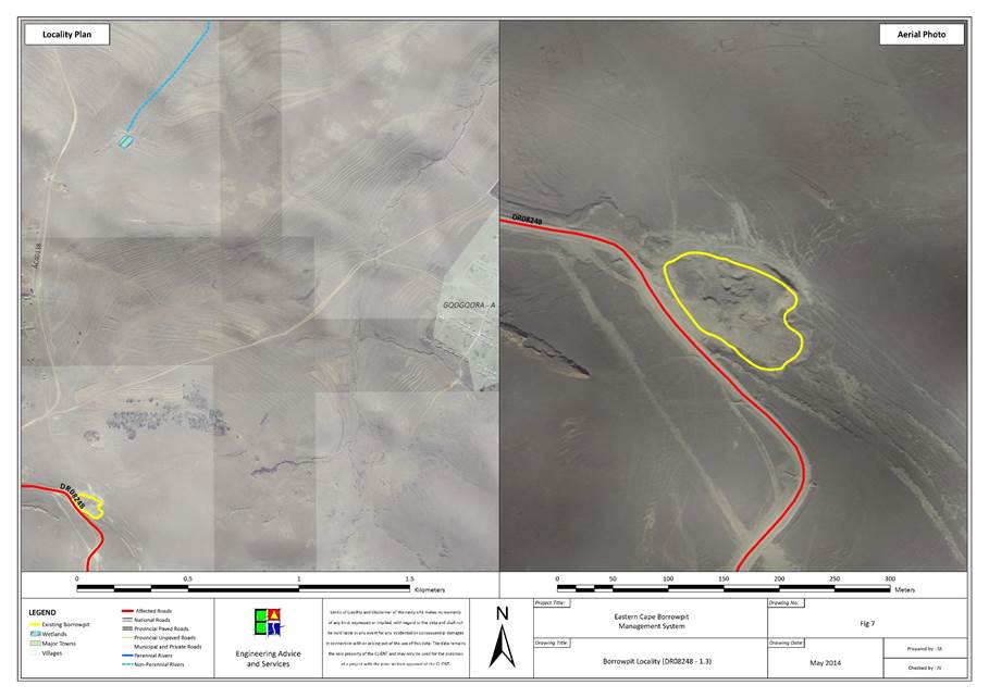
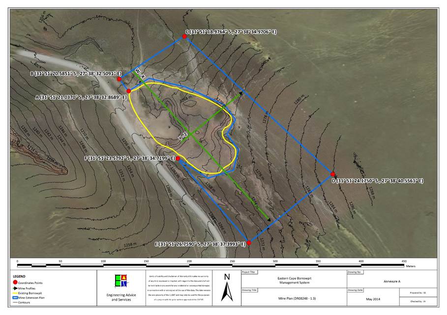 .
.
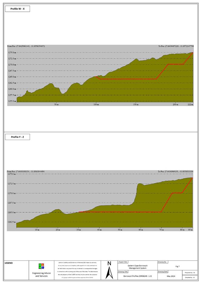
|
Contact Information
|
|
Contact
|
Name
|
Contact Number
|
|
Landowner
|
Communal
land
|
|
|
Ward
Councillor
|
Nolundi
Gertrude Futiso
|
073 331
7035
|
|
Municipal
Manager
|
Cllr.
Z Shasha
|
047 874
0010
|
|
Location Details
|
|
GPS Position:
|
S31 47 39.85 , E27 36 43.75
|
|
Topography:
|
Flat
plain
|
|
Distance from Road:
|
40m
|
|
Physical Details
|
|
Access:
|
Access
road is in poor condition.
|
|
Fencing:
|
None.
|
|
Borrow Pit Extent:
|
80m
x 70m
|
|
Proposed Mining Direction:
|
East
|
|
Material Availability:
|
40 000m3
|
|
Material Type:
|
Mudstone,
sandstone
|
|
Data Collection:
|
Residual
outcrop
|
|
Sample Collection and Tests Performed
|
|
Mudstone
|
Particle
size distribution, Atterberg Limits, Modified California Bearing Ratio, LA
Abrasion test, Wet and Dry Weathering Test.
|
|
Sandstone
|
2x
(Particle size distribution, Atterberg Limits, Modified California Bearing
Ratio)
|
|
Biophysical Environmental
Description
|
|
Vegetation and Status
|
Tsomo Grassland
|
|
Present Land Use
|
Cultivated and Degraded
|
|
CBA
|
CBA 3
|
|
Land Use Type
|
Communal
|
|
Agricultural features
|
Cultivated and Degraded
|
|
Alien invasive species
|
None
|
|
Potential Faunal Habitat:
|
Rocky habitat
|
|
Natural Drainage and Erosion
|
General sheetwash collecting in minor depressions in soil which
then washes into the river 100m west of the quarry.
|
|
Rivers and Drainage Lines
|
There is a river collecting runoff 100m west of the quarry.
|
|
Wetlands
|
None
|
|
Quaternary Catchment
|
S50E
|
|
Social Environment Description
|
|
Heritage
|
None
affected
|
|
Palaeontology
|
None
in Dolerite, Mudstones and Sandstones may have fossils
|
|
Archaeology
|
None
observed
|
|
Buildings and
Structures
|
Buildings in vicinity
|
|
Issus raised by I &
AP’s
|
Refer to section
|
Borrow Pit DR08248/11.2
|
Impact Assessment Mitigation
|
|
Issue
|
Description
|
Recommendation
|
|
Visual Exposure
|
Extension
could increase the visibility of the quarry.
|
Batter
the quarry face back to a 1/3 slope.
|
|
Natural Drainage and wetlands
|
None.
|
Avoid
removing material close to the nearby river to the west of the quarry.
|
|
Buildings
|
None.
|
None.
|
|
Overhead Services
|
None.
|
None.
|
|
Underground Services
|
None.
|
None.
|
|
Fences
|
None.
|
None.
|
|
Vegetation
|
|
|
|
Fauna
|
|
|
|
Agricultural features
|
None.
|
|
|
Grazing
|
None.
|
|
|
Mining Plan Details
|
|
Proposed mining direction:
|
East
|
|
Area to be mined
|
|
|
Projected volume
|
|
|
Access road
|
Access
road will be rehabilitated.
|
|
|
|
|
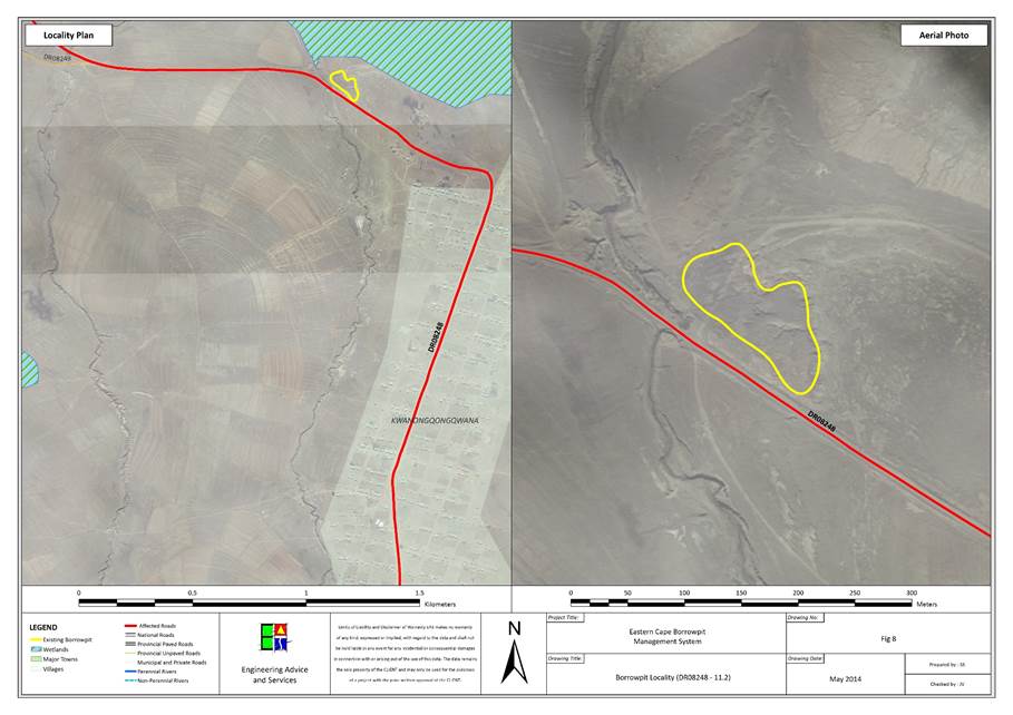
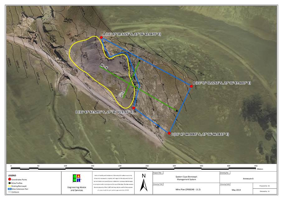
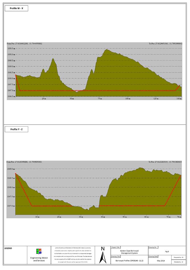
|
Contact Information
|
|
Contact
|
Name
|
Contact Number
|
|
Landowner
|
Communal
land
|
|
|
Ward
Councillor
|
Mayanzeke
Yamile
|
072
9758 813
|
|
Municipal
Manager
|
Cllr.
Z Shasha
|
047 874
0010
|
|
Location Details
|
|
GPS Position:
|
S31 46 11.732 , E27 35 35.143
|
|
Topography:
|
Gentle
north-eastern slope.
|
|
Distance from Road:
|
60m
|
|
Physical Details
|
|
Access:
|
The
access road into the borrow pit is adequate.
|
|
Fencing:
|
None.
|
|
Borrow Pit Extent:
|
70m
x 50m
|
|
Proposed Mining Direction:
|
South-west
towards the road.
|
|
Material Availability:
|
40 000m3
|
|
Material Type:
|
Mudstone
|
|
Data Collection:
|
Residual
outcrop
|
|
Sample Collection and Tests Performed
|
|
Mudstone
|
3x
(Particle size distribution, Atterberg Limits, Modified California Bearing
Ratio) + LA Abrasion test, Wet and Dry Weathering Test.
|
|
Biophysical Environmental
Description
|
|
Vegetation and Status
|
Tsomo Grassland
|
|
Present Land Use
|
Natural
|
|
CBA
|
CBA 3
|
|
Land Use Type
|
Communal
|
|
Agricultural features
|
None
|
|
Alien invasive species
|
None
|
|
Potential Faunal Habitat:
|
Grassland
|
|
Natural Drainage and Erosion
|
General sheetwash over a gentle slope.
|
|
Rivers and Drainage Lines
|
There is a natural drainage line 80m east of the quarry which
collects the runoff of the immediate area.
|
|
Wetlands
|
None
|
|
Quaternary Catchment
|
S50E
|
|
Social Environment Description
|
|
Heritage
|
None
affected
|
|
Palaeontology
|
None
in Dolerite, Mudstones and Sandstones may have fossils
|
|
Archaeology
|
None
observed
|
|
Buildings and
Structures
|
None
|
|
Issus raised by I &
AP’s
|
Refer to section
|
Borrow Pit DR08248/18.0
|
Impact Assessment Mitigation
|
|
Issue
|
Description
|
Recommendation
|
|
Visual Exposure
|
None.
|
Avoid
steel slopes and many stockpiles after the quarry has been used.
|
|
Natural Drainage and wetlands
|
None.
|
Batter
the slopes back to 1/3 and compact worked ground to avoid runoff collecting
dirt and washing it into nearby river.
|
|
Buildings
|
None.
|
None.
|
|
Overhead Services
|
None.
|
None.
|
|
Underground Services
|
None.
|
None.
|
|
Fences:
|
None.
|
None.
|
|
Vegetation
|
|
|
|
Fauna
|
|
|
|
Agricultural features
|
None.
|
None.
|
|
Grazing
|
None.
|
None.
|
|
Mining Plan Details
|
|
Proposed mining direction
|
South-west
towards the road.
|
|
Area to be mined
|
|
|
Projected volume
|
|
|
Access road
|
The
access road is in good condition.
|
|
|
|
|
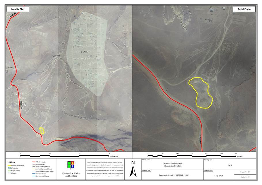
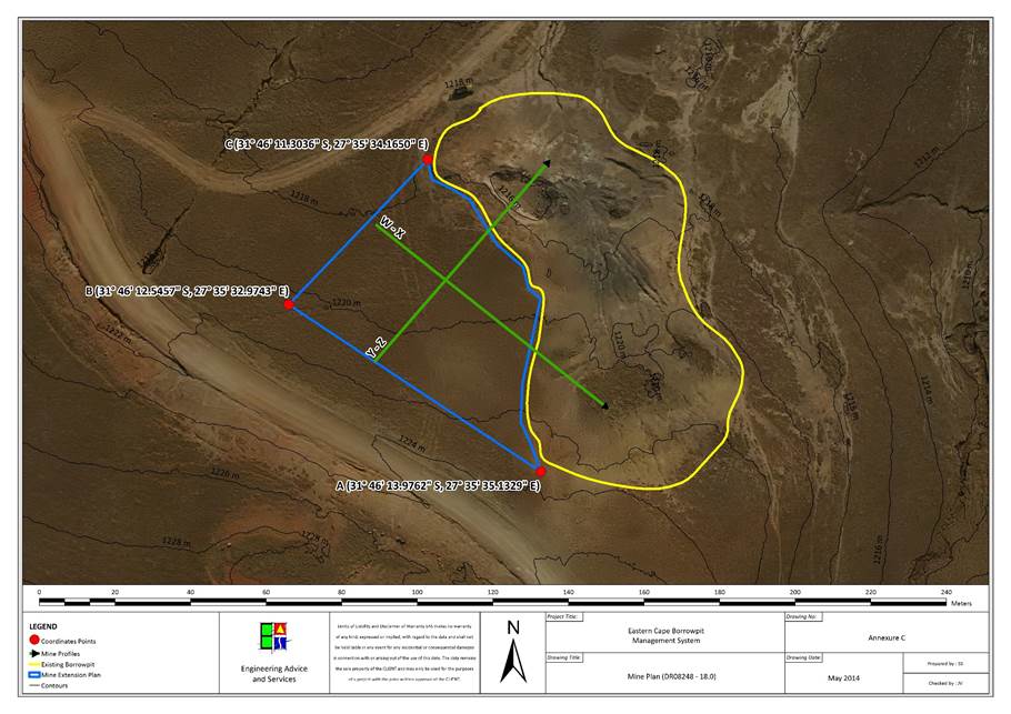
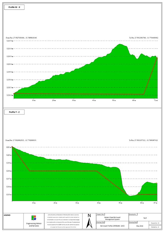
|
Contact Information
|
|
Contact
|
Name
|
Contact Number
|
|
Landowner
|
Communal
land
|
|
|
Ward
Councillor
|
Albertinah
Nokwetu Rotyi
|
072 084
8022
|
|
Municipal
Manager
|
Cllr.
Z Shasha
|
047 874
0010
|
|
Location Details
|
|
GPS Position:
|
S31 42.885 , E27 49.177
|
|
Topography:
|
|
|
Distance from Road:
|
|
|
Physical Details
|
|
Access:
|
Adequate
access
|
|
Fencing:
|
None
|
|
Borrow Pit Extent:
|
90m
x 40m
|
|
Proposed Mining Direction:
|
South
and West
|
|
Material Availability:
|
20 000m3
|
|
Biophysical Environmental
Description
|
|
Vegetation and Status
|
Tsomo Grassland
|
|
Present Land Use
|
Cultivated and Degraded
|
|
CBA
|
CBA 3
|
|
Land Use Type
|
Communal
|
|
Agricultural features
|
Cultivated and Degraded
|
|
Alien invasive species
|
None
|
|
Potential Faunal Habitat:
|
Rocky habitat
|
|
Natural Drainage and Erosion
|
Some erosion present
|
|
Rivers and Drainage Lines
|
None
|
|
Wetlands
|
None
|
|
Quaternary Catchment
|
T12C
|
|
Social Environment Description
|
|
Heritage
|
None
affected
|
|
Palaeontology
|
None
in Dolerite, Mudstones and Sandstones may have fossils
|
|
Archaeology
|
None
observed
|
|
Buildings and
Structures
|
Buildings
|
|
Issus raised by I &
AP’s
|
Refer to section
|
Borrow Pit DR08504/6.8
|
Impact Assessment Mitigation
|
|
Issue
|
Description
|
Recommendation
|
|
Visual Exposure:
|
The
visual exposure will likely increase with the extension of the mine.
|
Create
a berm between the road and the borrow pit.
|
|
Natural Drainage and wetlands:
|
There
are natural drainage ditches approximately 150m south-west and north-west of
the quarry.
|
Avoid
moving mining closer than 30m of the drainage ditches.
|
|
Buildings:
|
None
|
None
|
|
Overhead Services:
|
None
|
None
|
|
Underground Services:
|
The
road drainage might be affected if the quarry is extended too close to the
road, south of the quarry.
|
Avoid
the road drainage pipe just south of the quarry.
|
|
Fences:
|
None.
|
None.
|
|
Vegetation
|
|
|
|
Fauna
|
|
|
|
Agricultural features
|
|
|
|
Grazing
|
|
Recommendation
|
|
Mining Plan Details
|
|
Proposed mining direction:
|
West
and south
|
|
Area to be mined
|
|
|
Projected volume
|
|
|
Access road
|
No
access road needed.
|
|
|
|
|
4
Summary of the potential impacts, significance assessment and the proposed mitigation
measures
·
REGULATION 52 (2) (b): Assessment of
the potential impacts of the proposed mining operation on the environment,
socio- economic conditions and cultural heritage.
a) Description of the proposed mining operation.
i.
The main activities (e.g. access roads,
topsoil storage sites and any other basic prospecting design features )
ii.
Plan of the main activities with
dimensions
iii.
Description of construction,
operational, and decommissioning phases.
iv.
Listed activities (in terms of the NEMA EIA regulations)
The following methodology is to be applied in the specialist
studies for the assessment of potential impacts.
|
Criteria
|
Explanation
|
|
Nature
of impact
|
Review
the type of effect that a proposed activity will have on the environment and
should include “what will be affected and how?”
|
|
Extent
|
Indicate
whether the impact will be:
·
(S)
local
and limited to the immediate area of development (the site);
·
(L)
limited to within 5 km of the development; or
·
(R)
whether the impact may be realized regionally, nationally or even
internationally.
|
|
Duration
|
Review
the lifetime of the impact, as being:
·
(V)
very short term
(0 - 1 years),
·
(S)
short term
(1 - 5 years),
·
(M)
medium (5 - 15 years),
·
(L)
long term
(>15 years but where the impacts will cease after the operation of the
site), or
·
(P)
permanent.
|
|
Intensity
|
Establish
whether the impact is destructive or innocuous and should be described as
either:
·
(L)
low
(where no environmental functions and processes are affected)
·
(M)
medium
(where the environment continues to function but in a modified manner) or
·
(H)
high
(where environmental functions and processes are altered such that they
temporarily or permanently cease).
|
|
Probability
|
Consider
the likelihood of the impact occurring and should be described as:
·
(I)
improbable
(low likelihood)
·
(P)
probable
(distinct possibility)
·
(H)
highly probable
(most likely) or
·
(D)
definite
(impact will occur regardless of prevention measures).
|
|
Status
of the impact
|
Description
as to whether the impact will be positive (a benefit), negative (a cost), or
neutral.
|
|
Degree
of confidence
|
The
degree of confidence in the predictions, based on the availability of
information and specialist knowledge. This should be assessed as high, medium
or low.
|
|
Significance
|
·
(L)
Low:
Where the impact will not have an influence on the decision or require to be
significantly accommodated in the project design
·
(M)
Medium:
Where it could have an influence on the environment which will require
modification of the project design or alternative mitigation;
·
(H)
High:
Where it could have a ‘no-go’ implication for the project unless mitigation
or re-design is practically achievable.
|
Significance Rating
|
|
Duration
|
|
Permanent
|
Long
term
|
Medium
term
|
Short
term
|
Very
short term
|
|
|
High
Intensity
|
|
Extent
|
National
|
High
|
High
|
High
|
High
|
Medium
|
|
Regional
|
High
|
High
|
High
|
High
|
Medium
|
|
Local
|
High
|
High
|
Medium
|
Medium
|
Medium
|
|
Site
specific
|
Medium
|
Medium
|
Medium
|
Medium
|
Medium
|
|
|
Medium
Intensity
|
|
Extent
|
National
|
High
|
High
|
High
|
Medium
|
Medium
|
|
Regional
|
High
|
High
|
High
|
Medium
|
Medium
|
|
Local
|
Medium
|
Medium
|
Medium
|
Medium
|
Medium
|
|
Site
specific
|
Medium
|
Medium
|
Medium
|
Medium
|
Low
|
|
|
Low
Intensity
|
|
Extent
|
National
|
Medium
|
Medium
|
Medium
|
Medium
|
Medium
|
|
Regional
|
Medium
|
Medium
|
Medium
|
Medium
|
Medium
|
|
Local
|
Medium
|
Medium
|
Medium
|
Medium
|
Low
|
|
Site
specific
|
Medium
|
Medium
|
Medium
|
Low
|
Low
|
Furthermore, the following must be considered:
1.
Impacts should be described both before and after the proposed
mitigation and management measures have been implemented.
2.
All impacts should be evaluated for both the construction, operation and
decommissioning phases of the project, where relevant.
3.
The impact evaluation should take into consideration the cumulative
effects associated with this and other facilities which are either developed or
in the process of being developed in the region, if relevant.
4.
Management actions: Where negative impacts are identified, specialists
must specify practical mitigation objectives (i.e. ways of avoiding or reducing
negative impacts). Where no mitigation is feasible, this should be stated and
the reasons given. Where positive impacts are identified, management actions to
enhance the benefit must also be recommended.
5.
Monitoring: Specialists should recommend monitoring requirements
to assess the effectiveness of mitigation actions, indicating what actions are
required, by whom, and the timing and frequency thereof.
4.2
Identification of potential impacts
4.2.1
Possible impacts on biodiversity during mining construction and
operations
Mining construction and operations can result in a
range of negative impacts on terrestrial, marine and other aquatic ecosystems
if not properly managed. Table 6 describes impacts that may potentially occur
in the individual Borrow Pits (as per DMR guidelines) as well indicating the
relevant EMP section in Appendix C. The predicted significance of these are
summarised in Table 10, where SB = Significance BEFORE mitigation
and SA = Significance AFTER mitigation. No significant ancillary
linear infrastructure, such as roads, conveyors, power lines, pipelines and railways,
which can impact on biodiversity and ecosystem services are expected other than
minor access roads.
Refer to Table 6, Table
7, Table 10 and EMP guidelines Section.
Table 6: List of potential
Impacts relating to the expansion of Borrow Pits
|
Impact
|
Impact Description
|
Relevant EMP Section describing Mitigation Measures (clickable link)
|
|
Topography
|
Alteration
of topography through excavation of borrow pits and material removal
|
Topsoil and Subsoil Replacement
|
|
Erosion
|
Increased
erosion risk resulting from removal of vegetation and stockpiling of topsoil
|
Drainage and Erosion Control
|
|
Geology
|
Permanent
alteration of Geology through the removal of material from BP’s
|
|
|
Soils
|
Potential
loss of soil from BP’s due to removal of topsoil and stockpiling for
rehabilitation
|
Topsoil and Subsoil Replacement
|
|
Surface Water
|
Potential
increased sediment load in runoff water from borrow pits and road works
(Directly into Wetlands or Rivers)
|
Drainage and Erosion Control
|
|
Groundwater
|
Potential
impacts on groundwater as a result of seep contamination with chemicals as
well as fuels and lubricants required for operation of plant machinery
|
Waste Management and Ablution
Facilities
|
|
Air quality/Dust
|
Nuisance
impacts of dust generated from excavating, blasting, crushing, stockpiling
and road works on traffic on the roads and nearby residents.
|
Dust
|
|
Vegetation
|
Damage
to or clearing of natural habitat, fencing off of areas and/or increased
vehicular traffic, leading to loss of ecological communities, habitat for
species, changes to ecosystem services, and fragmentation or isolation of
habitats.
|
Biodiversity Requirements
|
|
Fire
|
Increased
risk of fire may interfere with natural fire regimes and adversely affect
biodiversity.
|
Biodiversity Requirements
|
|
Alien species
|
Introduction
or spread of alien invasive species, feral fauna (including agricultural and
commercial exotic species) and diseases of native flora and fauna.
|
Biodiversity Requirements
|
|
Habitat
|
Habitat
fragmentation, the disruption of migratory routes of faunal species or
ecological corridors enabling ecological or evolutionary processes, collisions
and road kills, dust generation and fallout.
|
Biodiversity Requirements
|
|
Fauna
|
Potential
small scale loss of fauna, particularly small animals confined to borrow pit,
resulting from habitat loss. It is not anticipated that endangered or rare
species will be present.
|
Biodiversity Requirements
|
|
Land capability/Agriculture
|
No
permanent significant impact on land capability is expected.
|
Topsoil and Subsoil Replacement
|
|
Grazing
|
Loss
of grazing to Landowner as a result of Borrow Pit
|
Topsoil and Subsoil Replacement
|
|
Fences
|
Significant
changes to landowners fencing as a result of BP expansion
|
Fencing
|
|
Noise
|
Noise
impacts during blasting and crushing activities are expected on nearby
residents.
|
Noise
|
|
Over/Under Services
|
Blasting
activities at the borrow pits may affect the nearby houses and
infrastructure.
|
Exiting Services
|
|
Visual Impact
|
An
existing visual impact occurs at all the borrow pits as they are existing
sites which have not been properly rehabilitated previously. After
rehabilitation, the proposed activities may substantially improve the visual
impact on the environment.
|
Visual Impacts Amelioration
|
|
Waste management
|
Pollution
of construction and domestic waste as well as waste water could lead to other
visual impacts and loss of natural habitat.
|
Waste Disposal
|
|
Socio-Economic Impacts
|
Formalisation
of the borrow pits would allow for regular routine maintenance of the roads
that will benefit local communities and residents and all road users along
the route.
|
|
|
Archaeology
|
(Depends
on HIA)
|
Historical, Archaeological and
Paleontological Sites
|
|
Heritage
|
(Depends
on HIA)
|
Historical, Archaeological and
Paleontological Sites
|
|
Palaeontology
|
(Depends
on PIA)
|
Historical, Archaeological and
Paleontological Sites
|
|
Buildings and Structures
|
Impacts
to Buildings and Structures in close proximity to the site
|
Demarcation the Mining Area
|
Where issues of significant importance have been
identified during the planning phase, appropriate measures have been
implemented in the mine planning phase to accommodate them. In addition,
during a site selection and feasibility phase, any Borrow Pits deemed to have
any biophysical or social features that could not be successfully mitigated or
avoided were not selected for this permitting process.
Whilst the residual Impact after the implementation of
mitigation measures will be Low to Negligible on most Borrow Pits, the
following Borrow Pits and Activities are deemed to have a Moderate or higher
residual significance after implementation of the EMP and the implementation of
the recommended mitigation measures:
Table 7: List of activities having Moderate or higher
Significance AFTER mitigation.
|
Borrow Pit
|
Impact
|
Additional measures
|
|
8041/5.9
|
|
|
|
8041/14.4
|
|
|
|
8041/28.8
|
|
|
|
8041/35.7
|
|
|
|
8041/37.7
|
|
|
|
8041/50.1
|
|
|
|
8247/2.5
|
|
|
|
8247/8.5
|
|
|
|
8247/19.1
|
|
|
|
8247/23.2
|
|
|
|
8247/Village
|
|
|
|
8248/1.3
|
|
|
|
8248/11.2
|
|
|
|
8248/18.0
|
|
|
|
8504/6.8
|
|
|
Table 11 provides a list of activities associated
with borrow pit mining that may be applicable for specific borrow pits.
No cumulative impacts are expected as a result of
the expansion of the Borrow Pits, due to the limited disturbance footprint.
Potential impacts are summarised in Table 8 with recommended
mitigation measures.
Table 8: Summary of potential impacts or heritage
resources.
|
Borrow Pit
|
Comment regarding Cumulative Impacts
|
Comment regarding mitigation measures
|
|
8041/5.9
|
|
|
|
8041/14.4
|
|
|
|
8041/28.8
|
|
|
|
8041/35.7
|
|
|
|
8041/37.7
|
|
|
|
8041/50.1
|
|
|
|
8247/2.5
|
|
|
|
8247/8.5
|
|
|
|
8247/19.1
|
|
|
|
8247/23.2
|
|
|
|
8247/Village
|
|
|
|
8248/1.3
|
|
|
|
8248/11.2
|
|
|
|
8248/18.0
|
|
|
|
8504/6.8
|
|
|
4.2.8
Potential impacts on communities, individuals or competing land
uses in close proximity.
These are summarised in Table 9 and recommended
mitigation measures provided.
Table 9: Summary of potential impacts on communities
|
Borrow Pit
|
Potential Impact
|
Comment regarding potential
impacts on communities in proximity
|
|
8041/5.9
|
|
|
|
8041/14.4
|
|
|
|
8041/28.8
|
|
|
|
8041/35.7
|
|
|
|
8041/37.7
|
|
|
|
8041/50.1
|
|
|
|
8247/2.5
|
|
|
|
8247/8.5
|
|
|
|
8247/19.1
|
|
|
|
8247/23.2
|
|
|
|
8247/Village
|
|
|
|
8248/1.3
|
|
|
|
8248/11.2
|
|
|
|
8248/18.0
|
|
|
|
8504/6.8
|
|
|
Refer to Appendix B for public participation notices and
correspondence from IAP’s.
Refer to Appendix C for any specialist reports. No
additional specialist reports were prepared.
Table 10:
Summary indicating significance of potential impacts relating to mining
activities (SB = Significance BEFORE Mitigation; SA = Significance AFTER
Mitigation)
|
8248/1.3
|
8248/11.2
|
8248/18
|
8247/2.5
|
8247/8.5
|
8247/23.2
|
8247/village
|
8247/19.1
|
8041/50.1
|
8041/37.7
|
8041/35.7
|
8041/28.8
|
8041/14.4
|
8041/5.9
|
8504/5.9
|
|
Impact
|
SB
|
SA
|
SB
|
SA
|
SB
|
SA
|
SB
|
SA
|
SB
|
SA
|
SB
|
SA
|
SB
|
SA
|
SB
|
SA
|
SB
|
SA
|
SB
|
SA
|
SB
|
SA
|
SB
|
SA
|
SB
|
SA
|
SB
|
SA
|
SB
|
SA
|
|
Topography
|
M
|
|
M
|
|
M
|
|
M
|
|
M
|
|
M
|
L
|
M
|
L
|
M
|
L
|
M
|
L
|
M
|
L
|
M
|
L
|
M
|
L
|
M
|
L
|
M
|
L
|
M
|
L
|
|
Erosion
|
M
|
|
M
|
|
L
|
|
M
|
|
M
|
|
L
|
N
|
M
|
L
|
L
|
N
|
L
|
N
|
L
|
N
|
L
|
N
|
L
|
N
|
M
|
L
|
L
|
N
|
L
|
N
|
|
Geology
|
L
|
|
L
|
|
M
|
|
L
|
|
M
|
|
M
|
L
|
M
|
L
|
M
|
L
|
M
|
L
|
M
|
L
|
M
|
L
|
M
|
L
|
M
|
L
|
M
|
L
|
M
|
L
|
|
Soils
|
L
|
|
L
|
|
L
|
|
L
|
|
L
|
|
L
|
N
|
L
|
N
|
L
|
N
|
L
|
N
|
L
|
N
|
L
|
N
|
L
|
N
|
L
|
N
|
L
|
N
|
L
|
N
|
|
Surface Water
|
L
|
|
M
|
|
L
|
|
L
|
|
M
|
|
L
|
N
|
M
|
L
|
M
|
L
|
L
|
N
|
M
|
L
|
L
|
N
|
M
|
L
|
L
|
N
|
L
|
N
|
L
|
N
|
|
Groundwater
|
L
|
|
M
|
|
L
|
|
L
|
|
L
|
|
L
|
N
|
L
|
N
|
L
|
N
|
L
|
N
|
L
|
N
|
L
|
N
|
L
|
N
|
L
|
N
|
L
|
N
|
L
|
N
|
|
Air quality/Dust
|
L
|
|
L
|
|
L
|
|
L
|
|
L
|
|
L
|
N
|
L
|
N
|
L
|
N
|
L
|
N
|
L
|
N
|
L
|
N
|
L
|
N
|
L
|
N
|
L
|
N
|
L
|
N
|
|
Vegetation
|
L
|
|
L
|
|
L
|
|
L
|
|
M
|
|
M
|
L
|
L
|
N
|
L
|
N
|
L
|
N
|
L
|
N
|
M
|
L
|
M
|
L
|
L
|
N
|
L
|
N
|
L
|
N
|
|
Fire
|
|
|
M
|
|
M
|
|
M
|
|
M
|
|
M
|
L
|
M
|
L
|
M
|
L
|
M
|
L
|
M
|
L
|
M
|
L
|
M
|
L
|
M
|
L
|
M
|
L
|
M
|
L
|
|
Alien species
|
L
|
|
L
|
|
L
|
|
L
|
|
L
|
|
L
|
N
|
L
|
N
|
L
|
N
|
L
|
N
|
L
|
N
|
L
|
N
|
L
|
N
|
L
|
N
|
L
|
N
|
L
|
N
|
|
Habitat
|
L
|
|
L
|
|
L
|
|
L
|
|
L
|
|
L
|
N
|
L
|
N
|
L
|
N
|
L
|
N
|
L
|
N
|
M
|
L
|
L
|
N
|
L
|
N
|
L
|
N
|
L
|
N
|
|
Fauna
|
L
|
|
L
|
|
L
|
|
L
|
|
L
|
|
L
|
N
|
L
|
|
L
|
N
|
L
|
N
|
L
|
N
|
M
|
L
|
L
|
N
|
L
|
N
|
L
|
N
|
L
|
N
|
|
Land capability/Agriculture
|
L
|
|
L
|
|
L
|
|
L
|
|
L
|
|
L
|
N
|
L
|
N
|
M
|
L
|
M
|
L
|
L
|
N
|
L
|
N
|
L
|
N
|
L
|
N
|
L
|
N
|
L
|
N
|
|
Grazing
|
L
|
|
L
|
|
L
|
|
L
|
|
L
|
|
L
|
N
|
L
|
N
|
M
|
L
|
M
|
L
|
L
|
N
|
L
|
N
|
L
|
N
|
L
|
N
|
L
|
N
|
L
|
N
|
|
Fences
|
L
|
|
L
|
|
L
|
|
L
|
|
L
|
|
L
|
N
|
L
|
N
|
L
|
N
|
L
|
N
|
L
|
N
|
L
|
N
|
L
|
N
|
L
|
N
|
L
|
N
|
L
|
N
|
|
Noise
|
L
|
|
L
|
|
L
|
|
L
|
|
L
|
|
L
|
N
|
L
|
N
|
L
|
N
|
L
|
N
|
L
|
N
|
M
|
L
|
L
|
N
|
L
|
N
|
L
|
N
|
L
|
N
|
|
Over/Under Services
|
L
|
|
L
|
|
L
|
|
M
|
|
L
|
|
L
|
N
|
L
|
N
|
L
|
N
|
L
|
N
|
L
|
N
|
L
|
N
|
L
|
N
|
L
|
N
|
M
|
L
|
L
|
N
|
|
Visual Impact
|
M
|
|
M
|
|
M
|
|
M
|
|
M
|
|
M
|
L
|
M
|
L
|
M
|
L
|
M
|
L
|
M
|
L
|
M
|
L
|
M
|
L
|
M
|
L
|
M
|
L
|
M
|
L
|
|
Waste management
|
L
|
|
L
|
|
L
|
|
L
|
|
L
|
|
L
|
N
|
L
|
|
L
|
N
|
L
|
N
|
L
|
N
|
L
|
N
|
L
|
N
|
L
|
N
|
L
|
N
|
L
|
N
|
|
Socio-Economic Impacts
|
|
|
|
|
|
|
|
|
|
|
|
|
|
|
|
|
|
|
|
|
|
|
|
|
|
|
|
|
|
|
|
Archaeology
|
|
|
|
|
|
|
|
|
|
|
|
|
|
|
|
|
|
|
|
|
|
|
|
|
|
|
|
|
|
|
|
Heritage
|
|
|
|
|
|
|
|
|
|
|
|
|
|
|
|
|
|
|
|
|
|
|
|
|
|
|
|
|
|
|
|
Palaeontology
|
|
|
|
|
|
|
|
|
|
|
|
|
|
|
|
|
|
|
|
|
|
|
|
|
|
|
|
|
|
|
|
Buildings
|
L
|
|
L
|
|
L
|
|
L
|
|
L
|
|
L
|
N
|
M
|
L
|
L
|
N
|
L
|
N
|
L
|
N
|
L
|
N
|
L
|
N
|
L
|
N
|
L
|
N
|
L
|
N
|
|
|
|
|
|
|
|
|
|
|
|
|
|
|
|
|
|
|
|
|
|
|
|
|
|
|
|
|
|
|
|
|
OVERALL
|
|
L
|
|
L
|
|
|
|
L
|
|
L
|
|
N
|
|
L
|
|
L
|
|
L
|
|
L
|
|
L
|
|
L
|
|
L
|
|
L
|
|
L
|
Table 11: Listed Activities associated with Borrow
Pits
|
Land clearance for mining purposes
and/or ancillary activities (12, 13 and 14 of LN3)
|
(LN3: 12) The clearance of an area of 300
square metres or more of vegetation where 75% or more of the vegetative
cover constitutes indigenous vegetation.
|
Within any critically endangered or
endangered ecosystem listed in terms of section 52 of the NEMBA or prior to
the publication of such a list, within an area that has been identified as
critically endangered in the National Spatial Biodiversity Assessment 2004;
|
|
(b) Within critical biodiversity areas
identified in bioregional plans;
|
|
(LN2: 13) The clearance of an area
of 1 hectare or more of vegetation where 75% or more of the vegetative cover
constitutes indigenous vegetation.
|
Critical biodiversity areas and
ecological support areas as identified in systematic biodiversity plans
adopted by the competent authority.
|
|
National Protected Area Expansion
Strategy Focus areas.
|
|
Outside urban areas, the following:
(aa) A protected area identified in
terms of NEMPAA, excluding conservancies;
(bb) National Protected Area
Expansion Strategy Focus areas;
(cc) Sensitive areas as identified
in an environmental management framework as contemplated in chapter 5 of the
Act and as adopted by the competent authority;
(dd) Sites or areas identified in
terms of an International Convention;
(ee) Core areas in biosphere
reserves;
(ff) Areas within 10
kilometres from national parks or world heritage sites or 5
kilometres from any other protected area identified in terms of NEMPAA or
from the core area of a biosphere reserve;
(gg) Areas seawards of the
development setback line or within 1
kilometre from the high-water mark of the sea if no such development setback
line is determined.
iii. In urban areas, the following:
(aa) Areas zoned for use as public
open space;
(bb) Areas designated for
conservation use in Spatial Development Frameworks adopted by the competent
authority or zoned for a conservation purpose;
(cc) Areas seawards of the
development setback line;
(dd) Areas on the watercourse side
of the development setback line or within 100
metres from the edge of a watercourse where no mentioned in Listing Notice
1.
|
|
(LN3: 14) The clearance of an area
of 5 hectares or more of vegetation where 75% or more of the vegetative cover
constitutes indigenous vegetation
|
All areas outside urban areas
|
|
Land transformation for mining
purposes (23, 24 of LN1; 15 of LN2)
|
(LN1: 23) The transformation of
undeveloped, vacant or derelict land to –
(i) residential, retail, commercial,
recreational, industrial or institutional use, inside an urban area, and
where the total area to be transformed is 5
hectares or more, but less than 20
hectares, or
(ii) residential, retail,
commercial, recreational, industrial or institutional use, outside an urban
area and where the total area to be transformed is bigger than 1
hectare but less than 20 hectares; -
|
|
(LN1: 24) The transformation of land
bigger than 1000 square metres in size, to residential, retail, commercial,
industrial or institutional use, where, at the time of the coming into effect
of this Schedule such land was zoned open space, conservation or had an
equivalent zoning.
|
|
Physical alteration of undeveloped,
vacant or derelict land for residential, retail, commercial, recreational,
industrial or institutional use where the total area to be transformed is 20
hectares or more;
|
The decommissioning phase and
closure of the quarry will involve removal of all debris and rehabilitation of
areas not rehabilitated during the operational phases of the project. This
will comprise the scarification of compacted areas, reshaping of areas,
topsoiling and regenerating all prepared surfaces. The crusher and screening
plants will be dissembled and all other infrastructural development such as
haulage roads and stock pile areas will be rehabilitated.
Mine closure upon completion
of the mining operation needs to be conducted in accordance to the objectives
outlined in this report. The recommendations outlined in this report regarding
precision blasting of quarry sides, topsoil replacement and re-vegetation all
need to be complied with before mine closure can be considered.
The stages for
rehabilitation, which need to be adhered to in order to meet the closure
objectives, are as follows:
·
Over the lifespan of the borrow
pit, rehabilitation should commence initially in areas that are no longer being
mined.
·
If mining is expanded into the
proposed extension, rehabilitation is the adjacent quarry should be commenced
at least twelve months before commencement of that phase.
·
The same strategy will be applied
to future mining phases during the quarries lifespan.
·
Upon completion of the final
mining phase, final quarry rehabilitation (which will involve the
rehabilitation of the areas currently being mined out and the storage and
processing areas) will be completed within 12 months of operation closure.
·
The proposed closure costs will be
absorbed throughout the operation life of the quarry, as rehabilitation towards
final closure objectives will be conducted continuously during mining
operations.
In order to ensure that this EMP is effectively
implemented, it is important that regular external audits are conducted.
The DRPW must appoint an independent ECO in order
to oversee compliance with the EMP by undertaking monthly site inspections,
quarterly audits and post construction/operation site visits. The audits shall
aim at addressing environmental issues identified on site and to provide
recommendations through the audit reports.
Audit Reports shall be provided to the DRPW, the
Project Managers/Engineers and the DMR.
|
Item
|
Requirements/
Conditions/Mitigation Measures
|
Responsibility
|
C
|
Comment
|
|
|
|
|
|
|
|
Environmental Authorization
|
Notification
of DEA&DP for any project changes/ deviations
|
DRPW
|
|
|
|
Notification
of DEA &DP on ECO appointment
|
DRPW
|
|
|
|
Notification
of DEA&DP on the commencement of the project
|
|
|
|
Notification
of Interested and Affected Parties in the vicinity of construction of
commencement date and completion
|
Contractor
|
|
|
Copy
of the Environmental Authorisation kept on site
|
|
|
Copy
of the Construction EMP kept on site.
|
|
|
ECO’s
monitoring and audit reports to be kept on site and be available for
inspection by any relevant and competent authority
|
|
|
An
environmental audit report must be submitted to DEA&DP upon completion of
the construction and rehabilitation activities
|
|
|
|
Environmental
Agreement between DRPW and Contractor
|
DRPW
& Contractor
|
|
|
|
|
|
|
|
|
|
Filing System for Environmental Documentation
(Method Statements)
|
Construction
camp location and layout
|
Contractor
to submit a method statement of how he will handle the following
|
|
|
|
Site
Clearing
|
|
|
Handling
of Hazardous Substances
|
|
|
Solid
Waste Management
|
|
|
Handling
of Wastewater
|
|
|
Erosion
and Sediment Control
|
|
|
Fire
Preventative Measures
|
|
|
Cement
and Concrete Batching
|
|
|
Vegetation
and Rehabilitation
|
|
|
|
|
|
|
|
|
Environmental Permitting Requirements
|
National
Water Act (No. 36 of 1998) – River crossing
|
Contractor
|
|
|
|
National
Water (No. 36 of 1998) – Water abstraction
|
|
|
|
Minerals
and Petroleum Resources Development Act (No. 28 of 2002) – Borrow pits
|
|
|
|
National
Heritage Resources Act (No. 25 of 1999)
|
|
|
|
National
Environmental Management: Waste Act (No. 59 of 2008) – Waste Management
|
|
|
|
|
|
|
|
|
|
Administration
|
Organogram
of contractor’s management structure available
|
Contractor
|
|
|
|
Has
a ELO been appointed
|
|
|
Is
the ELO permanently on site
|
|
|
Is
the ELO submitting reports to the resident engineer on a monthly basis
|
|
|
|
|
|
|
|
|
Environmental Awareness Training
|
Is
the ELO appropriately trained to carry out training and mentoring on
environmental management?
|
Contractor
|
|
|
|
Has
Environmental Awareness Training (EAT) been carried out?
|
|
|
|
Are
records of EAT available
|
|
|
|
|
|
|
|
|
|
Camp Depot
|
Perimeter
fencing erected and maintained
|
Contractor
|
|
|
|
Water
available for human consumption at the site office and working areas points
on site
|
|
|
Provision
of appropriate ablution facilities
|
|
|
Housing
of labour force
|
|
|
Storage
of equipment and material at designated areas
|
|
|
|
|
|
|
|
|
Maintenance & Refuelling
|
Dip
trays for emergency repairs should be provided
|
Contractor
|
|
|
|
Suitable
containers should be provided for collecting waste oil
|
|
|
|
Vehicle
servicing areas should be demarcated
|
|
|
|
Leaking
vehicles should be repaired immediately
|
|
|
|
Refuelling
areas should be designated
|
|
|
|
Refuelling
areas should be protected against pollution or surfaced
|
|
|
|
Wastewater
collection measures should be in place at vehicle washing areas
|
|
|
|
|
|
|
|
|
|
Environmental management of Construction
Activities
|
Work
restricted to 07h00 – 17h00 on weekdays
|
Contractor
|
|
|
|
Work
restricted to 07h00 – 14h00 on Saturdays
|
|
|
|
Work
only allowed after hours in exceptional circumstances
|
|
|
|
Notifications
of interruption of service due to construction
|
|
|
|
Inform
nearby I&APs of noisy after hours work
|
|
|
|
Inform
landowners of any planned damage to properties
|
|
|
|
Maintenance
of photographic record of damage
|
|
|
|
Compensation
for damage to property
|
|
Demarcation
of no-go areas and proper signage
|
|
|
|
Designate
smoking areas where smoking can occur in a controlled environment
|
|
|
|
Prevent
casual access to the construction site
|
|
|
|
Contractor’s
employees to be clearly identifiable
|
|
|
|
Blasting
to comply with relevant regulations
|
|
|
|
No
unemployed labour seekers to gather on site
|
|
|
|
Inform
employees of site specific environmental risks
|
|
|
|
Cover
material loads in transit
|
|
|
|
Safety & Security
|
Road
users and pedestrians should be informed of alternative routes
|
Contractor
|
|
|
|
General
compliance with the Occupational Health and Safety Act (No. 85 of 1993)
|
|
|
|
Protection
of workers during thunderstorms
|
|
|
|
Periodic
checking of excavations
|
|
|
|
Appropriate
traffic signs displayed
|
|
|
|
|
|
|
|
|
|
Cement & Concrete Batching Plant
|
Cement
mixed in allocated areas
|
|
|
|
|
Cleaning
of cement mixing trays be done on proper cleaning trays
|
Contractor
|
|
|
|
Proper
storage of cement bags before disposal
|
|
|
|
Excess
concrete should be disposed of at a licensed landfill site
|
|
|
|
Cement
laden runoff from concrete stockpile should be controlled
|
|
|
|
|
|
|
|
|
|
Storage of Hazardous Substances
|
Suitable
storage of hazardous substances
|
Contractor
|
|
|
|
Hazard
signs indicating the hazardous substance at storage site
|
|
|
|
Petroleum
tanks contained in a bund wall, which is more than 10% its capacity
|
|
|
|
Material
and safety data sheets should be readily available for hazardous substances
|
|
|
|
Run-off
from storage site should be contained
|
|
|
|
Hazardous Waste
|
Proper
collection and disposal of contaminated soils at approved facilities/site
|
Contractor
|
|
|
|
Proper
storage of used oils before disposal
|
|
|
|
Appropriate
disposal of hazardous waste at approved landfill sites
|
|
|
|
Unused
or rejected bituminous products should be returned to the supplier not
disposed or buried in a landfill site.
|
|
|
|
Waste
disposal tracking records
|
|
|
|
|
|
|
|
|
|
Wastewater
|
Oil
separation/settlement system should be placed for water run-off from washing
areas, workshops, fuel depots to pass through
|
Contractor
|
|
|
|
|
|
|
Wastewater
shouldn’t be disposed into municipal stormwater system
|
|
|
|
Conservancy
tanks should be used for wastewater collection
|
|
|
|
|
|
|
|
|
|
Private Property Access and Security
|
Notify
landowners prior to undertaking construction work
|
Contractor
|
|
|
|
Access
to adjacent private properties prohibited except under official business
|
|
|
|
|
|
|
|
|
|
Rehabilitation
|
Suitable
rehabilitation of cut and fill slopes
|
Contractor
|
|
|
|
Topsoil
replacement
|
|
All
construction residue removed after construction
|
|
All structures
should be removed
|
|
Contaminated
soil should be removed and properly disposed
|
|
Scarify
areas compacted by vehicle movements
|
|
Rehabilitation
plan should be in place
|
|
Borrow
pits reshaped to even surfaces and closed off
|
|
|
|
|
|
|
|
Compliance and Penalties
|
Non-compliance
directive been issued to the contractor
|
ECO
|
|
|
Non-compliance
directive been recorded in a dedicated register and reported in monthly
reports and at monthly site meetings
|
ELO
|
|
|
Has
a penalty for non-compliance been implemented by engineer?
|
RE/ELO
|
|
The Quantum of Financial Provision shall be
calculated using DMR’s Guideline Document for the Evaluation of the Quantum of
Closure-Related Financial Provided by a mine (2005). In terms of the guideline
the Borrow Pits classify as class C mines (low risk) of low to moderate
sensitivity.
Rehabilitation of the borrow pit upon mining
completion will include the clearing up of access roads, mining infrastructure
and the site office. It should be noted at this stage that rehabilitation
should be commenced immediately on sites that are no longer mined or to be
mined in the following three years.
Th Quantum calculation is as follows:
|
Component
|
Quantity
|
Rate
|
Amount
|
|
Consultants fees to assist the DMR with
rehabilitation recommendations
|
|
|
|
|
Topsoil acquisition to rehabilitate (per m²)
|
|
R1.50 m²
|
|
|
5% allocation for sundries
|
|
|
|
|
Contingency amount (10%)
|
|
|
|
|
Total:
|
|
|
|
|
Establishment of rehabilitation personnel and equipment
|
|
|
|
|
De-establishment of plant (per move)
|
|
R2 000
|
|
|
Levelling of worked areas as per
recommendations of the EMP
|
|
|
|
|
Topsoiling (per m²)
|
|
R1.50/m²
|
|
|
Hydroseeding
|
|
R1.00/m²
|
|
|
Fencing of mine and final levelling of mining
footprint
|
|
|
|
|
10% contingency amount (10%)
|
|
|
|
|
Total:
|
|
|
|
(Indicate that the required amount will be provided
should the right be granted).
Need letters or signatures.
|
Herewith I, the person whose name and identity
number is stated below, confirm that I am the person authorised to act as
representative of the applicant in terms of the resolution submitted with the
application, and confirm that the above report comprises EIA and EMP compiled
in accordance with the guideline on the Departments official website and the
directive in terms of sections 29 and 39 (5) in that regard, and the
applicant undertakes to execute the Environmental management plan as
proposed.
|
|
Full Names and Surname
|
|
|
Identity Number
|
|
(Provide the information
referred to in the guideline)
Refer to
adverts and correspondence
Information was provided, including a cover letter
and Background Information Document, to the persons listed in Table 1. A link to the report on the website was also provided.
Table 12:
List of which parties identified in 7.1 above that were in fact consulted, and
which were not consulted
|
Person(s)
|
Contact Details
|
Position
|
|
Nolundi Gertude Futiso
|
073 331 7035
|
Ward Councillor
|
|
Mayanzeke Yamile
|
072 9758 813
|
Ward Councillor
|
|
Noloyiso Mto
|
083 591 9238
|
Ward Councillor
|
|
Albertinah Nokwetu Rotyi
|
072 084 8022
|
Ward Councillor
|
|
Nozuko Sygnoria Mafanya
|
082
838 0490
|
Ward Councillor
|
|
Zukiswa Qayiya
|
082 828 0549
|
Ward Councillor
|
|
Dudu Kaspile
|
072 9758 818
|
Ward Councillor
|
|
|
|
Municipal Manager
|
|
|
|
|
|
|
|
|
|
|
|
|
Table 13: Summary table (refer
to letters in Appendices)
See above
Refer to
appendices
Any issues raised have been addressed by
altering the mine layout plan if necessary and/or are covered in the EMP
section. Residual issues are as follow:
Refer to EMP
(Describe how the
applicant intends to inform his or her employees of any environmental risk
which may result from their work).
Refer to EMP
(Describe the manner in
which the risk must be dealt with in order to avoid pollution or degradation of
the environment)
Before the commencement of any work on site, the
Contractor's site management staff shall attend an environmental awareness
training session, of at least one-hour duration, presented by the ECO and RE.
The Contractor shall liaise with the ECO prior to the commencement date to fix
a date and venue for the training session. The Contractor shall provide a
suitable venue with facilities, and ensure that the specified employees attend
the training session.
The information presented at the course shall be
communicated by the Contractor to the rest of his employees on the site, to any
new employees coming onto site after the initial training course and to his/her
suppliers. The presentation shall be conducted, as far as is possible, in the
employees’ language of choice. As a minimum, training shall include:
•
Explanation of the importance of complying with the EMP;
•
Discussion of the potential environmental impacts of construction
activities;
•
Explanation of the management structure of individuals responsible for
matters pertaining to the EMP;
•
Explanation of the manner in which environmental risks and impacts must
be dealt with in order to avoid pollution and the degradation of the
environment;
•
Employees’ roles and responsibilities, including emergency preparedness;
•
Explanation of the mitigation measures that must be implemented when
carrying out their activities;
•
Explanation of the specifics of the EMP; and
•
Explanation of the Environmental Do’s and Don’ts (below).
The Contractor shall keep records of all
environmental training sessions, including names of attendees, dates of their
attendance and the information presented to them. Records of environmental
training sessions shall be submitted to the ECO.
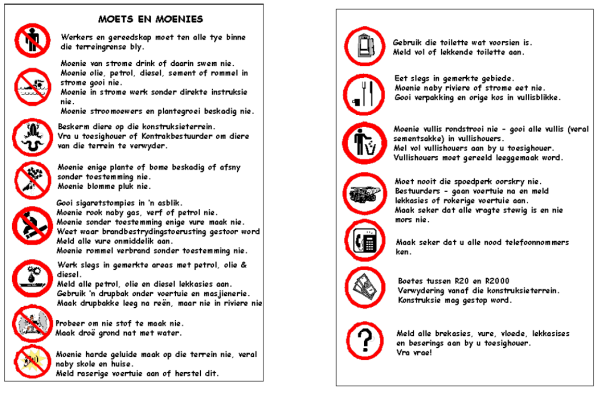
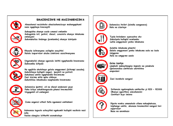
Appendix
A: Environmental Management Plan
Appendix
B: Detailed Impact Assessment scores
Appendix
C: Potential Species list
Appendix
D: References
Appendix
E: Interested and Affected Party Correspondence
Appendix
F: Borrow Pit Geological Test Results
This Environmental
Management Plan (EMP) contains guidelines, operating procedures and
rehabilitation control requirements, which will be binding on the holder of the
mining right after approval of the EMP.
The impacts identified and
listed in Table 1 of the previous chapter will be managed / controlled as set
out under mitigating measures and as detailed in this part for the more
significant impacts during the operational phase.
·
The layout plans required for EMP
approval are included in Section 3 above of this report.
·
The mining area must be clearly demarcated
by means of beacons at its corners. These beacons must be firmly erected and
maintained in their correct positions throughout the life of the mine.
·
The existing quarry scar should be
shaped so that the working behaves as a localised sump to ensure run-off is
contained after wet periods thereby reducing siltation of the drainage channel
downstream.
·
Areas not earmarked for future
mining activities should be rehabilitated with topsoil to encourage vegetation
regrowth. The old workings and stockpiles should be levelled and excavation
scars covered with topsoil to encourage grass regrowth and rehabilitation of
land surface.
·
No disused stockpiles should occur
/ be placed outside of the mining footprint upon project completion.
·
Future mine faces need not be
rehabilitated but should be sloped to prevent unnecessary erosion.
·
A stockpile should be left within
the mine footprint for future patch gravelling and road repair programmes
outside this contract.
·
Note that the stockpile should not
be placed in the lowest part of the quarry where there is a possibility of it
being partly or completely submerged by accumulating water.
·
It is recommended that the quarry
be extended eastern and western directions to avoid moving too close to the
housing settlement to the south of the quarry.
·
Working hours shall be deemed as
normal working hours of 07:00 to 17:00, Mondays to Fridays, 07:00 to 13:00 on
Saturdays, excluding public holidays. These conditions can, however, be
changed after written communication with the Regional Manager (DME).
The environment affected by
the mining operations shall be rehabilitated by the holder, as far as is
practicable, to its natural state or to a predetermined and agreed to standard
or land use which conforms with the concept of sustainable development. The
affected environment shall be maintained in a stable condition that will not be
detrimental to the safety and health of humans and animals and that will not
pollute the environment or lead to the degradation thereof.
It is the responsibility of
the holder of the mining right to ensure that the contractor on the site and
the employees are capable of complying with all the statutory requirements,
which must be met in order to mine, which includes the implementation of this
EMP.
If operations are to be
conducted in an area that has already been disturbed, the holder must reach
specific agreement with the Regional Manager concerning the responsibilities
imposed upon themselves pertaining to the rehabilitation of the area and the
pollution control measures to be implemented.
The EMP recommendations
contained in the Mitigation section of this report should be read and applied
in conjunction with the measures mentioned throughout this report.
Layout Plan
- Copies of the layout plans
are included in this report and must be available at the
mining site. These plans must include the following:
- Details
on site locality.
- Site
boundaries.
- Layout
of waste management facilities.
- Access
roads and entry points to each site.
- Drainage
features and stormwater control (for the reduction of potential erosion).
- Storage
facilities (water, fuel and lubricants, chemicals and other materials,
stockpiles, topsoil and spoil areas).
- Intended
mitigation measures to reduce potential impacts.
- The plan must
be updated on a regular basis and forwarded to the Regional Manager.
pdates should include the actual progress of the
establishment of surface infrastructure, mining operations and
rehabilitation.
- Final layout plans will
be submitted at closure of the borrow pits or upon the cessation of
operations.
Demarcation the Mining Area
- The mining areas must
be clearly demarcated. Demarcation be means of beacons at corner and along
boundaries (if there is no visibility between the comer beacons).
- Permanent beacons must
be firmly erected and maintained in their correct positions for the
duration of the operation. Permanent beacons are indicated on the layout
plans or prescribed by the Regional Manager.
- Mining and resultant
operations shall only take place in demarcated areas.
- It is important that a
detailed photographic record of the demarcated areas is taken before the
commencement of operations. These records are to be kept (by the
Contractor) for reference purposes during the rehabilitation phase of the
sites.
Fencing
- The perimeter of the mining
areas (as indicated on the layout plans) will be fenced with
stock-proof fencing.
- Access gateways for the
proposed mining areas must be secured with a suitable lock.
Signage
- ‘No unauthorised access’
signs will be erected at the gates to the borrow pits.
- Heavy vehicle crossings will
be at the intersections of the access tracks and the roads.
- Cautions signs and 40
km/h signs shall be placed at regulation distances from
heavy vehicle crossing signs.
Restrictions on Mining
- The Regional Manager may
prohibit the conducting of mining operations in vegetated areas on
assessment of the applications.
- No operations will
be conducted within 5 m of excluded areas.
Exiting Services
- Existing services
infrastructure (Telkom and Escom lines and water pipelines) must
be clearly marked and not damaged in any way.
- Consent should
be obtained from the relevant service providers and the relevant landowner
should be notified in advance should services need to be
interrupted for any reason.
10.1.2 Biodiversity
Requirements
Protection of Flora and Fauna
- Search and rescue
operations for Red List Species must be undertaken before
the commencement of site clearing activities.
- Indigenous vegetation
encountered on the sites are to be conserved and left intact.
- It is important that
clearing activities are kept to the minimum and take place in a phased
manner. This allows animal species to move into safe areas and prevents
wind and water erosion of the cleared areas.
- Stripped vegetation should
be temporarily stored during mining operations and to be used later to
stabilise slopes. This excludes exotic invasive species.
- A faunal specialist is
required to remove and relocate any faunal species disturbed by the mining
processes.
- No animals are to be harmed
or killed during the course of mining.
- Workers are NOT allowed to
collect any flora or snare any faunal species. All flora and fauna remain
the property of the land owner and must not be disturbed,
upset or used without their express consent.
- It is the responsibility of
the Contractor to provide sufficient fuel for cooking and heated as needed
by the staff.
- No domestic animals are
permitted on the sites.
- Trees and shrubs that are
directly affected by the mining operations may be felled or cleared only
be the express written permission of the ECO.
- Weeds and alien species must
be cleared by hand before the rehabilitation phase of the areas. Removal
of alien plants are to be done according to the Working for Water
Guidelines.
- The Contractor is
responsible for the removal of alien species within all areas disturbed
during mining activities. Disturbed areas include (but are not limited to)
access roads, construction camps, borrow pits areas and temporary storage
areas.
- In consultation with
relevant authorities, the Engineer my order the removal of alien plants
(when necessary). Areas within the confines of the borrow pits are to be
included.
- All alien plant material
(including brushwood and seeds) should be removed from site and disposed
of at a registered waste disposal site. Should brushwood be utilised for
soil stabilization or mulching, it must be seed free.
- Rehabilitation of
vegetation of the site must be done as described in the
Rehabilitation Plans.
Fires
·
The Contractor must ensure that an
emergency preparedness plan is in place in order to fight accidental fires or
veld fires, should they occur. The adjacent land owners/users/managers should
also be informed or otherwise involved.
·
Enclosed areas for food
preparation should be provided and the Contractor must strictly
prohibit the use of open fires for cooking and heating purposes.
·
The use of branches of trees and
shrubs for fire-making must be strictly prohibited.
·
The Contractor should
take all reasonable and active steps to avoid increasing the risk of fire
through their activities on-site. No fires may be lit except at places approved
by the EO.
·
The Contractor must
ensure that the basic fire-fighting equipment is to the satisfaction of the
Local Emergency Services.
·
The Contractor must
supply all living quarters, site offices, kitchen areas, workshop areas,
materials, stores and any other relevant areas with tested and approved
fire-fighting equipment.
·
Fires and “hot work” must
be restricted to demarcated areas.
·
A braai facility may be considered
at the discretion of the Contractor and in consultation with the ECO. The area must
be away from flammable stores. All events must be under management’s
supervision and a fire extinguisher will be immediately
available. “Low-smoke” fuels must be used (e.g., charcoal) and smoke control
regulations, if applicable, must be considered.
·
The Contractor must
take precautions when working with welding or grinding equipment near potential
sources of combustion. Such precautions include having a suitable, tested and
approved fire extinguisher immediately at hand and the use of welding curtains.
Soil Aspects
·
Sufficient topsoil must be stored
for later use during decommissioning, particularly from outcrop areas.
·
Topsoil shall be removed from all
areas where physical disturbance of the surface will occur.
·
All available topsoil shall be
removed after consultation with the Botanist and horticulturalist prior to
commencement of any operations.
·
The removed topsoil shall be
stored on high ground within the mining footprint outside the 1:50 flood level
within demarcated areas.
·
Topsoil shall be kept separate
from overburden and shall not be used for building or maintenance of roads.
·
The stockpiled topsoil shall be
protected from being blown away or being eroded. The application of a suitable
grass seed/runner mix will facilitate this and reduce the minimise weeds.
10.1.3 Historical,
Archaeological and Paleontological Sites
Archaeological Sites
- If
concentrations of archaeological heritage material and human remains are
uncovered during construction activities, ALL (including the immediate
vicinity) work must cease immediately and be reported to the
Eastern Cape Provincial Heritage Resources Authority so that systematic
and professional investigation / excavation can be undertaken. Human
remains include:
- Remnants
of stone-made structures
- Indigenous
ceramics
- Bones
- Stone
artefacts
- Ostrich
eggshell fragments
- Marine
shells
- Charcoal
/ ash concentrations
- The
contractor must take reasonable precautions to prevent
removal or damage to any such article. The Engineer must be
informed immediately upon discovery.
- Work
may only resume once clearance is given in writing by the archaeologist.
- Robbing
or removal of any material from these sites for construction purposes is
strictly prohibited. Disturbance or alteration is a criminal offence
punishable by law.
- Only
existing roads may be used during development phase. Informal access roads
should first be surveyed for heritage sites before
construction may commence.
Graves
If a grave site is uncovered
or discovered before the commencement of work, all work in the immediate
vicinity MUST be stopped and the Engineer informed. The following are to be
adhered to upon discovery of graves during mining activities and the management
of grave sites:
- Where
possible, the area where the grave site is located should
not be disturbed, particularly in instances where exhumation cannot be
undertaken or is deemed not permissible by SAHRA.
- Where
it is necessary to exhume and re-bury graves, the Contractor will need to
apply for the necessary permissions / permits. This includes the
acquisition of permits from:
- SAHRA
- Nation
and provincial health departments
- Community
(and next of kin) consultation
- Collaboration
with a forensic archaeologist if new graves are located during
construction or operation.
- Unless
such a time as permission for exhumation is granted, all site preparation
and operations will stop.
- The
mine will adhere to the requirements laid out by the Human
Tissues Act (No 65 of 1983) and the National Heritage Resources Act (No 25
of 1999).
- Respect
must be given to the customs and beliefs of the affected
relatives. Where requested, exhumation will be conducted in the presence
of the relatives or community representatives.
- Exhumations
under the Human Tissues Act will be conducted under the supervision of an
undertaker or specialist.
- Exhumations
conducted under the National Heritage Resources Act will be conducted
under the supervision of an archaeologist.
- In
the event that additional graves are located during construction and
operation, SAHRA must be notified and permits for relocation
of graves permitted.
Paleontological Sites
- A
palaeontologist must screen High risk Borrow Pit sites before commencement
and apply for relevant permits from SAHRA. Furthermore for sites with a
fossil record of importance but be visited by an appointed archaeologist
so that it can be documented as mining progresses.
- Awareness
of potential fossil bones on sites must be maintained by the
Contractor and ECO. A palaeontologist must be notified if
any fossil bones are uncovered.
- The surface crust must
be broken up on completion of the project, to obliterate temporary roads
or working surfaces. Earth embankments will then be
established where appropriate to prevent erosion.
- The demolition and removal
of the remains of all structures erected at borrow pits will
be done on the completion of the project.
- It is important that all
rehabilitated areas merge with the immediate environment. Any negative
visual impacts must be rectified to the Regional Managers
satisfaction.
- Overburden will
be placed back into excavation as part of the rehabilitation programme.
10.1.5 Noise
- Any blasting activities and
road construction must be limited to daylight hours. If any
complaints are received, the hours of the activities will be
reviewed.
- Compliance with the
appropriate legislation with respect to noise is mandatory.
- Regular maintenance of
equipment and vehicles must be undertaken.
- The contractor will
communicate with potentially affected communities in the event that
activities continue outside of the stipulated hours. This must
be done prior to commencement of such activities.
- Should member of the
surrounding communities wish to lodge complains, a complaints register must
be made available on the sites. The contractor is responsible for dealing
with the complaint appropriately and timeously.
10.1.6 Dust
- To manage complaints
relation to impacts on the nearby communities, a dust register will
be developed.
- If required, water spray
vehicles will be used to control wind cause by strong winds
/ mining activities on the works.
- No over-watering of the
mining area or road surfaces.
- Wind screens should
be used to reduce wind and dust in open areas.
10.1.7
Waste Management and Ablution Facilities
- It
is important to identify a suitable site for spoiling excavated material.
Excavated spoil must be stockpiles and used in profiling and
rehabilitation of the borrow pits.
- Sufficient
weather and scavenger- proof bins with lids (to prevent the escape of
litter) will be provided, and be easily accessible at all
points where wastes are generated.
- Sites
must be kept clean and free of litter. No litter from the
site should be allowed to disperse to surrounding areas.
- All
personnel should be instructed to dispose of all waste in
the proper manner.
- It
is recommended that recycling is practised. The Contractor must
identify and separate materials, and provide separate marked bins for
these items.
- Construction
materials must be suitable stored and protected so that they
do not become damaged and unusable.
- The
responsibility of regular disposal of all waste generated as a result of
the construction, falls to the Contractor. This must be done at suitable
and licensed municipal waste disposal facilities. Waste disposal slips must
be kept for auditing purposes.
- Excess
material may also be spoiled in used borrow pits as part of the
rehabilitation process.
- Construction
waste must be removed immediately upon completion of each
phase of the project and disposed of appropriately.
- A
safe disposal slip must be kept on record as proof of final
disposal of potentially hazardous substances.
- No
waste may be burned on site.
- General
waste is to be collected either by the local Municipality or removed by
the contractor. The frequency of collections should be such
that waste containment receptacles do not unduly accumulate or overflow.
- The
holder of the mining permit must, as a minimum requirement,
provide pit latrines for employees in such a way that they do not cause
water or other pollution. Proper hygiene measures will be
established.
- Portable
toilets shall be provided adjacent to the site entrance
indicated on the layout plans and must be screened with
shade cloth.
- The
use of existing facilities must take place in consultation
with the landowner.
- The
effluent water from the camp washing facility must be disposed
of in a properly constructed French drain situated as far as possible, but
not less than 200 meters, from any stream, river, pan, damn, spring or
borehole.
- Only
domestic type wash water must enter this drain.
- Any
effluent containing oil, grease or other industrial substances must
be collected in suitable receptacles and removed from the sites, either
for sale or for appropriate disposal at a recognised facility.
- Spills
must be cleaned up immediately to the satisfaction of the
Regional Manager. It is important to remove the spillage together with the
polluted soil and dispose of them at a recognised facility.
- Non-biodegradable
refuse (glass bottles, plastic bags, metal scrap, etc.) should
be stored in a container at a collecting point and collected on a weekly
basis. It must then be disposed of at a recognised disposal
facility. Specific precautions must be taken to prevent
refuse from being dumped or in the vicinity of the sites.
- Biodegradable
refuse must either be handled as indicated above or be
buried in a pit excavated for that purpose and covered with layers of
soil, incorporating a final 0.5
meter thick layer of topsoil (where possible). Provision should be made
for future subsidence of the covering.
·
Topsoil shall be removed from all
areas where physical disturbance of the surface will occur.
·
All available topsoil shall be
removed after consultation with the Regional Manager prior to commencement of
any operations.
·
The removed topsoil shall be
stored on high ground within the mining footprint outside the 1:50 flood level
within demarcated areas (Appendix 1)
·
Topsoil shall be kept separate
from overburden and shall not be used for building or maintenance of roads.
·
The stockpiled topsoil shall be
protected from being blown away or being eroded. The application of a suitable
grass seed/runner mix will facilitate this and reduce the minimise weeds.
Existing roads are adequate,
but if future mining operations do require the construction of roads, the
following must be adhered to:
·
The access to the mining area must
be established in accordance with the authorisation from the various government
departments (Department of Economic Affairs Environment and Tourism (DEAET),
Department of Roads and Transport (DRT) and the Department of Minerals and
Energy) and existing roads shall be used as far as practical.
·
Should a portion of the access
road be newly constructed the following must be adhered to:
- The route shall be selected
that a minimum disturbance to natural vegetation
- Water courses and steep
gradients shall be avoided as far as practical.
- Adequate drainage and
erosion protection in the form of cut-off berms or trenches shall be
provided where necessary.
- Authorisation may be
required from the DEAET if the road is constructed in “sensitive areas”,
as this represents a listed activity in terms of environmental
legislation.
·
The erection of gates in a fence
line and the open and closed status of gates shall be clarified in consultation
with the landowner and maintained throughout the operational period.
·
No other routes shall be used by
vehicles or personnel for the purpose of gaining access to the site.
·
Newly constructed access roads
shall be adequately maintained so as to minimise dust, erosion or undue surface
damage.
·
The liberation of dust into the
surrounding environment shall be effectively controlled by the use of inter
alia, water spraying and /or other dust-allaying agents. The speed of haul
trucks and other vehicles must be strictly controlled to avoid dangerous
conditions, excessive dust or excessive deterioration of the road being used.
·
The access roads to the quarry
sites must be strictly maintained during the operation process. Sections of the
access road that erodes during the mining process shall be suitably
rehabilitated upon completion of the project.
Stormwater and Erosion Control
- Stormwater Management Plans
must be developed for each borrow pit. They should
include the following:
- The management of
stormwater during construction.
- The installation of
stormwater and erosion control infrastructure.
- The management of
infrastructure after completion of construction.
- Drainage works are required
to prevent stormwater from entering or exiting the borrow pits and
quarries to prevent silt laden surface water from draining into river
systems in proximity to the borrow pits and quarry sites. Stormwater must
be prevented from entering or running of borrow pits and quarry sites.
- To ensure that borrow pits
are not subjected to excessive erosion and capable of drainage run-off
with minimum risk of scour, their slops should be profiled
at a maximum 1:3 gradient.
- Diversion channels should
be constructed ahead of the open cuts, and above emplacement areas and
stockpiles to intercept clean run-off and divert it around disturbed areas
into the natural drainage system downstream of the borrow pits.
- Rehabilitation is necessary
to control erosion and sedimentation of all existing mined areas (where
works will take place).
- Existing vegetation must
be retained as far as possible to minimise erosion problems.
- It is importation that the
rehabilitation of borrow pits and quarries are planned and completed in
such a way that the run-off water will not cause erosion.
- Visual inspections will
be done on a regular basis with regard to the stability of water control
structure, erosion and siltation.
- Sediment-laden run-off from
cleared ares must be prevent from entering rivers and
streams.
- No river or surface water
may be affected by sill emanating from the borrow pits or quarries.
- No site offices or camp
sites will be constructed on the site under current operating conditions.
- Should a site office be
temporarily required, a moveable container type must be used
and placed in a disturbed area within the existing borrow pit.
- Since the vehicles are not
owned by the quarry owner, there will be no vehicle maintenance or storage
area required.
- The maintenance of vehicles
and equipment used for any purpose during the mining operation will take
place off-site.
- Equipment used in the
mining process must be adequately maintained so that during operations it
does not spill oil, diesel or hydraulic fuel.
- Machinery or equipment used
in the mining area must not constitute a pollution hazard in respect of
the above substances. The Regional Manager (DME) shall order such
equipment to be repaired or withdrawn from the site if she considers the
equipment or machinery to be polluting and irreparable.
Waste Disposal
- Suitable covered
receptacles shall be available at all times and conveniently placed for
the disposal of waste.
- All used oils, grease or
hydraulic fluids shall be placed therein and these receptacles will be
removed from the site on a regular basis for disposal at a registered or
licensed disposal facility.
- All spills must be cleaned
up immediately to the satisfaction of the Regional Manager be removing the
spillage entirely together with the polluted soil and by disposing of them
at a recognized facility.
- Fuel spillage should be
contained with a hydrocarbon absorbent and thoroughly removed once
spillage control and clean-up has been achieved.
- On site operators should
also have contact details for properly trained on-site accident assistance
such as Waste-Tech, which can be called upon in emergency situations.
- Mining shall only take
place within the approved demarcated mining area.
- Mining may be limited to
the areas indicated by the Regional Manager on assessment of the
application.
- The holder of the mining
permit shall ensure that operations take place only in the demarcated
areas as described in this report.
- Watering to minimise the
effect of dust generation should be carried out as frequently as
necessary. Noise should also be kept within reason.
- No workers will be allowed
to damage or collect any indigenous plant or snare any animal.
- Grass and vegetation of the
immediate environment, or adapted grass / vegetation will be
re-established on completion of mining activities, where applicable.
- No firewood to be collected on
site, and the lighting of fires must be prohibited.
- Cognisance is to be taken
of the potential for endangered species occurring in the area. It is
considered unlikely, however, that these species will be affected by the
proposed mining activity, or the access road.
Whenever any excavation is
undertaken, the following procedures shall be adhered to:
- Topsoil shall be handled as
described in this EMP.
- Excavations shall take
place only within the approved demarcated mining area.
- Excavations
must follow the contour lines where possible.
·
The construction site will not be
left in any way to deteriorate into an unacceptable state.
·
The excavated area must serve as a
final depositing area for waste rock and overburden during the rehabilitation
process.
- Waste as described in
Chapter 4.2 will not be permitted within the mine footprint.
- Once excavations have been
filled with overburden, rocks and coarse natural materials and profiled
with acceptable contours (including erosion control measures), the
previous stored topsoil shall be returned to its original depth over the
mine area.
- The area shall be
fertilised if necessary to allow vegetation to establish rapidly. The
site shall be seeded with a local or adapted indigenous seed mix in order
to propagate the locally occurring flora.
Blasting Activities
6.
Blasting should be designed based on a risk level of 0.03.
7.
Maximum charge per delay must be restricted to 112
kg.
8.
Stemming of blast holes should be taken to a maximum to
reduce the possibility of fly rock.
9.
Blasting mats / timber boarding or other means must be
used for larger blasts to reduce safety and noise impacts.
10.
Vibrometers should adjacent to the water reservoir and the
nearest dwelling to record peak particle velocities for each blast.
11.
Chemicals used in blasting must not be allowed to leach
into groundwater.
12.
Neighboring communities and relevant authorities must be
notified by the Contractor 24 hours prior to blasting.
13.
Controlled blasting techniques must be used during
blasting work to minimize any damage to the final profile.
14.
Spillage of material from surface excavation, whether by blasting or
other means, must be limited by the Contractor. All necessary
precautions including covering the rock prior with sufficient loos material
prior to blasting, if necessary, should be used to prevent the
blasted material from being thrown.
- No processing or waste pile
areas are currently required, but should Scribante construction utilise
the site for the quarrying and processing of gravel areas as indicated on
the map in Appendix 1.
- Quarry operators and
labourers are to be accommodated off site.
- No overnighting in the
study area will be allowed.
- Field personnel will have
sufficient kitchen and sanitary facilities during working hours.
- Toilets will be provided if
additional workers are to be on site and must be situated in an area where
no negative impact will occur.
- Clean
water (drinking quality) must be available to workers.
- Rivers
and groundwater must not be impacted negatively upon.
- Natural
vegetation must not be disturbed unnecessarily in and around the quarry
site.
- The mine area and surrounds
will be kept neat and tidy at all times.
·
Processing areas and waste piles
shall be established within a clearly demarcated area.
·
This area will include the
footprint where commercial stockpiles will be positioned during the daily
operation of the quarry. Monitoring and supervision of the processing area
will be controlled by the office, which will be situated adjacent to these
workings.
Rehabilitation of Processing and Excavation Areas
- Coarse material and
overburden must be removed from stockpiles and dumped into the mining
excavations.
- On completion of mining,
the surface of the processing areas especially if compacted due to hauling
and dumping operations shall be scarified to a depth of at least 200
mm and graded to an even surface condition and the previously stored
topsoil will be returned to its original depth over the area.
- The area shall be
fertilised if necessary to allow vegetation to establish rapidly. The
site shall be seeded with suitable grasses and local indigenous seed mix.
- Excavations may be used for
the dumping of construction wastes. This shall be done in
such a way as to aid rehabilitation.
- Waste (non-biodegradable
refuse) will not be permitted to be deposited in the excavations.
- If a reasonable assessment
indicates that the re-establishment of vegetation is unacceptably slow,
the Regional Manager may require that the soil be analysed and any
deleterious effects on the soil arising from the mining operation, be
corrected and the area be seeded with a vegetation seed mix to her or his
satisfaction. This must be done in conjunction with the ECO.
- Final rehabilitation must
comply with the requirements mention in the Rehabilitation Plan.
Labour and Affected Parties
1.
Where possible, laborers from the nearby communities should
be appointed.
2.
If applicable, suitable accommodation and security must be
provided during construction and by the contractors for their workers.
3.
If applicable, the contractor in conjunction with the client should
develop policies and procedures with regard to employee accommodation.
4.
Management commitments will be implemented by the
contractor with respect to noise, dust, safety and blasting. The contractor shall
furthermore ensure that their staff is trained regarding the Safety and Health
Environmental (SHE) procedures that are to be followed on site. Penalty clauses
for transgressions will also be considered in this regard.
5.
The contractor must ensure that the standard safety
measures as stipulated in the Mine, Health and Safety Act are complied with.
6.
All employees and contractors must be briefed about
appropriate road safety measures. Penalties and disciplinary actions will be
imposed on employees and contractors for non-compliance with safety,
environmental and social measures.
7.
Complaints should be dealt with timeously. This requires
the joint formulation of compliance contract and grievance procedures and
project-specific communication mechanisms (eg the keeping of complaints
registers).
8.
Inadvertent access to dangerous construction areas must be
prevented. Such areas must be strictly controlled using fencing,
warning signs and access control.
9.
The contractor must implement strict access control
measures wherever @outsider@ are accommodated in construction camps. Only
authorized personnel are allowed at the camp site.
10.
Workers may only be housed in surrounding villages if the relevant
authorities in the villages are satisfied with this arrangement.
The overall objective of the
rehabilitation plan is to minimize adverse environmental impacts associated
with the quarrying activities whilst maximizing the future utilization of the
property. The idea, therefore, is to leave the mined out quartzitic sandstone
quarry in a conditions that reduces many of the negative impacts associated
with a mined out area. Significant aspects to be borne in mind in this regard
is visibility of the mining scar, revegetation of the mining footprint and
stability and environmental risk in an old mine environment. The depression
and immediate area of the working must also be free of alien vegetation.
Alternative land uses such as agriculture, housing, waste disposal or
alternative mining applications are unsuitable for a post-mining scenario.
The proposed quarrying and
rehabilitation procedures have been formulated to optimise the extraction of
raw material while creating stable quarry sides that will not present an
unreasonable safety risk once mine closure has been approved. Mining
operations will be conducted in stages corresponding to the creation of
precision blasted quarry sides and a bench at the base of the working. Each
phase will be mined over a five year period and will be audited on an annual
basis.
Additional broad
rehabilitation strategies / objectives include the following:
- Rehabilitating the
worked-out areas to take place concurrently within prescribed framework
established in the EMP.
·
All infrastructure, equipment,
plant and other items used during the mining period will be removed from the
site (section 44 of the MPRDA).
·
Waste material of any description,
including scrap, rubble and tyres, will be removed entirely from the mining
area and disposed of at a recognised landfill facility. It will not be
permitted to be buried or burned on site.
·
Final rehabilitation shall be
completed within a period specified by the Regional Manager.
General plans outlining the
mining details indicate the proposed progressive development of the quarry is
included in Appendix 1.
Topsoil and
Subsoil Replacement
Topsoil and subsoil will be
stripped separately from the area of each year of mining. The topsoil and
subsoil removed from the initial cut will be stockpiled separately and only
used in rehabilitation work towards the end of the quarrying operation. This
is in contract to the gravel mining operation where rehabilitation and topsoil
replacement was earmarked at the completion of each phase.
Stripped overburden will be
backfilled into the worked out areas and used to soften quarry slopes where
needed. Stripped topsoil will be spread over the re-profiled areas to an
adequate depth to encourage plant regrowth. The vegetative cover will be
stripped with the thin topsoil layer to provide organic matter to the relayed
material and to ensure that the seed store contained in the topsoil is not
diminished. Reseeding may be required should the stockpiles stand for too long
and be considered barren from a seed bank point of view. Stockpiles should
ideally be stored for no longer than a year.
The topsoil and overburden
will be keyed into the reprofiled surfaces to ensure that they are not eroded
or washed away. The topsoiled surface will be left fairly rough to enhance
seedling establishment, reduce water run-off and increase filtration. Latent
impacts will be monitored by the Department of Minerals and Energy over a five
year period after quarry operations cease before a final mine closure certificate
can be granted by the DME.
Revegetation
All prepared surfaces will be
seeded with suitable grass species to provide an initial ground cover and
stabilize the soil surface. Whilst Chloris gayana and Themeda
triandra are the preferred species to use for revegetation by the quarry
owner, other species that can work in this regard include the following and can
either be collected on site (using a mower or by hand) or purchased from a
relevant local seed supplier:
|
Botanical
name
|
Common
name
|
|
Chloris
gayana
|
Rhodes
grass
|
|
Chloris
virgata
|
Feather-top
Chloris
|
|
Cynodon
dactylon
|
Couch
grass
|
|
Eragrostis
curvula
|
Weeping
love grass
|
|
Melinis
repens
|
Natal red
top
|
|
Panicum
coloratum
|
Small
Buffalo Grass
|
|
Panicum
deustum
|
Broad-leaved
Panicum
|
|
Stenotaphrum
secundatum
|
Buffalo
turf grass
|
|
Themeda
triandra
|
Rooigras
|
The overall revegetation plan
will, therefore, be as follows:
·
Ameliorate the aesthetic impact of
the site
·
Stabilise disturbed soil and rock
faces
·
Minimize surface erosion and
consequent siltation of natural water course located on site
·
Control wind-blown dust problems
·
Enhance the physical properties of
the soil
·
Re-establish nutrient cycling
·
Re-establish a stable ecological
system
Every effort must be made to
avoid unnecessary disturbance of the natural vegetation during quarrying
operations.
Drainage
and Erosion Control
To control the drainage and
erosion at site the following procedures will be adopted:
·
Areas where mining is completed
should be rehabilitated immediately.
·
Areas to be disturbed in future
mining operations will be kept as small as possible (i.e. conducting the
quarrying operations in phases), thereby limiting the scale of erosion.
·
Quarry slopes will be profiled to ensure
that they are not subjected to excessive erosion but capable of drainage
run-off with minimum risk of scour (maximum 1:3 gradient).
·
Diversion channels will be
constructed ahead of the open cuts as well as above emplacement areas and
stockpiles to intercept clean run-off and divert it around disturbed areas into
the natural drainage system downstream of the quarry.
·
Quarrying will be confined to the
existing mining footprint as per the existing gravel mining license.
·
All existing mined areas will be
revegetated to control erosion and sedimentation
·
Existing vegetation will be
retained as far as possible to minimize erosion problems.
Visual Impacts Amelioration
The overall visual impact of
the proposed mining operations will be minimised by the following mitigating
measures:
- Confining the mining
footprint to an area as small as possible
- Commencing the operations
from the west into the mine target area from a low point that is not
visible to neighbouring landowners / land users
- Integrating the mines into the
existing land slope
- Re-topsoiling and
vegetating all disturbed areas
- Use indigenous trees around
the perimeter of the mine to mask quarry scars.
Adequate management,
maintenance and monitoring will be carried out annually by the applicant to
ensure successful rehabilitation of the property until a closure certificate is
obtained.
To minimise adverse
environmental impacts associated with quarrying operations it is intended to
adopt a progressive rehabilitation programme, which will entail carrying out
the proposed rehabilitation procedures concurrently with quarrying activities.
·
Regular monitoring of all the
environmental management measures and components should be carried out by the
holder of the mining permit to ensure that the provisions of this programme are
adhered to.
·
Ongoing and regular reporting of
the progress of implementation of this programme must be done. An
environmental audit shall be carried out by an independent consultant on an
annual basis. The findings of this audit must be reported back to the Regional
Director. This should include visual inspections on erosion and physical
pollution.
·
A Performance Assessment Report
must be submitted to the Regional Director after each audit as per Regulation
55 of the MPRDA.
·
Any change to the mining process
needs to be documented during the audit process and the necessary changes
recorded to facilitate future mining operations and audit investigations.
·
Adherence to the impacts
associated with the proposed mining operations, as outlined in the Impact
Assessment section of this report, must be addressed in the annual audit.
·
Inspections and monitoring shall
be carried out on both the implementation of the programme and the impact on
plant and animal life.
·
Adherence to concerns raised by
IAP’s during the public participation process should receive special attention
during the environmental audit and correspondence to the various IAP’s should
be made on an annual basis in this regard.
- Layout plans must
be updated on a regular basis and updated copies will be
submitted to the Regional Manager upon the completion of each audit
investigation.
- Any emergency or unforeseen
impact must be reported to the Regional Manager within 14
days of such event being noticed.
- An assessment of
environmental impacts that were not properly addressed or were unknown
when the EMP was compiled, shall be carried out and added as
a corrective action.
The on-site manager is
responsible for the training of all staff. Regular training sessions are
recommended and shall include basic environmental awareness. It
is important that training registers are kept as proof for auditing purposes.
The following environmental training should be included:
·
The importance of conformance with
all environmental policies.
·
Environmental impacts of the
proposed activities (actual or potential).
·
Improved personal performance and
the environmental benefits thereof.
·
Roles and responsibilities of
achieving conformance with environmental policy and procedures.
·
Associated procedures and
emergency preparedness and response requirements.
·
Potential consequences of
departure from specified operating procedures.
·
Mitigation measures required to be
implemented when carrying out their work activities.
a)
The on-site manager must
maintain a register of all environmental incidents occurring as a result of the
associated activities in terms of the contract. The following environmental
incidents must be included:
· Fires
· Accidents
· Hazardous material spills that contaminate soil or
water resources
· Non-compliance with applicable legislation
· Non-compliance with this EMP.
b)
Environmental incidents must
be investigated be the competent person and the environmental incident report will
be forwarded to the permit holder. Incident reports should be presented within
five working days of the incident. The environmental incident report must
include:
· A description of the incident.
· Actions taken to contain any damage to the
environment, personnel or the public.
· Actions taken to repair / remediate any damage.
c)
The prescription of additional
measures that may be required to remediate damage that results from the
incident as well as prevention of similar incidents occurring in the future.
When the holder of a mining
right intends closing the mining operation, an environmental risk report shall accompany
the application for closure. The requirements of such a risk report are
contained in Regulation 60 of the MPRDA.
The decommissioning phase and
closure of the quarry will involve removal of all debris and rehabilitation of
areas not rehabilitated during the operational phases of the project. This
will comprise the scarification of compacted areas, reshaping of areas,
topsoiling and regenerating all prepared surfaces. The crusher and screening
plants will be dissembled and all other infrastructural development such as
haulage roads and stock pile areas will be rehabilitated.
Mine closure upon completion
of the mining operation needs to be conducted in accordance to the objectives
outlined in this report. The recommendations outlined in this report regarding
precision blasting of quarry sides, topsoil replacement and re-vegetation all
need to be complied with before mine closure can be considered.
The stages for
rehabilitation, which need to be adhered to in order to meet the closure
objectives, are as follows:
·
Over the lifespan of the borrow
pit, rehabilitation should commence initially in areas that are no longer being
mined.
·
If mining is expanded into the
proposed extension, rehabilitation is the adjacent quarry should be commenced
at least twelve months before commencement of that phase.
·
The same strategy will be applied
to future mining phases during the quarries lifespan.
·
Upon completion of the final
mining phase, final quarry rehabilitation (which will involve the rehabilitation
of the areas currently being mined out and the storage and processing areas)
will be completed within 12 months of operation closure.
·
The proposed closure costs will be
absorbed throughout the operation life of the quarry, as rehabilitation towards
final closure objectives will be conducted continuously during mining
operations.
|
SCHEDULE OF FINES FOR ENVIRONMENTAL DAMAGE OR EMP TRANSGRESSIONS
(Based
on City of Cape Town: Standard Environmental Specifications (03/2002)
Note:
The maximum fine for any environmental damage will never be less than the
cost of applicable environmental rehabilitation.
|
|
CEMP TRANSGRESSION OR RESULTANT ENVIRONMENTAL DAMAGE
|
MIN.
FEE
|
MAX.
FEE
|
|
Failure
to report environmental damage or CEMP transgressions to the ECO or RE.
|
R1000
|
R2000
|
|
Failure
to carry out instructions of the ECO or RE regarding the environment or the
CEMP
|
R2000
|
R4000
|
|
Failure
to comply with prescriptions for supervision for loading and off-loading of
delivery vehicles
|
R500
|
R1000
|
|
Failure
to comply with prescriptions for securing of loads to ensure safe passage of
delivery vehicles
|
R500
|
R1000
|
|
Failure
to comply with prescriptions for the storage of imported materials within a
designated contractors yard
|
R500
|
R1000
|
|
Failure
to comply with prescribed administration, storage or handling of hazardous
substances
|
R500
|
R1000
|
|
Failure
to comply with fuel storage, refuelling, or clean-up prescriptions
|
R500
|
R1000
|
|
Failure
to comply with prescriptions for the use of ablution facilities
|
R500
|
R1000
|
|
Failure
to comply with prescriptions for the use of designated eating areas, heating
sources for cooking or presence of fire extinguishers
|
R500
|
R1000
|
|
Failure
to comply with prescriptions regarding water provision
|
R500
|
R1000
|
|
Failure
to comply with prescriptions regarding fire control
|
R500
|
R1000
|
|
Failure
to comply with prescriptions for solid waste management (incl. paint chips,
cement and concrete)
|
R500
|
R1000
|
|
Failure
to comply with prescriptions to prevent water pollution
|
R500
|
R1000
|
|
Failure
to comply with prescriptions regarding workshop equipment maintenance and
storage
|
R500
|
R1000
|
|
Failure
to comply with prescriptions regarding noise levels of construction
activities
|
R500
|
R1000
|
|
Failure
to comply with prescriptions regarding working hours
|
R500
|
R1000
|
|
Failure
to comply with prescriptions regarding lighting and aesthetics
|
R500
|
R1000
|
|
Failure
to comply with prescriptions regarding silt, debris and other obstruction
removal
|
R500
|
R1000
|
|
Failure
to comply with prescriptions regarding water diversion and drainage
|
R500
|
R1000
|
|
Failure
to comply with prescriptions regarding erosion and scour protection
|
R500
|
R1000
|
|
Failure
to comply with prescriptions traffic accommodation
|
R500
|
R1000
|
|
Failure
to comply with prescriptions regarding tree and vegetation removal/damage
|
R5000
|
R20000
|
|
Failure
to comply with prescriptions regarding method statements
|
R500
|
R5000
|
|
Failure
to comply with prescriptions regarding environmental awareness training
|
R500
|
R5000
|
|
Failure
to comply with prescriptions regarding appointment of an Environmental
Officer and monitoring of CEMP compliance
|
R500
|
R1000
|
|
Failure
to comply with prescriptions regarding site demarcation and erection of
fences
|
R500
|
R5000
|
|
Failure
to comply with prescriptions regarding control of vehicles and plant on access
routes
|
R500
|
R1000
|
|
Failure
to comply with prescriptions regarding information posters
|
R500
|
R1000
|
|
Failure
to comply with prescriptions regarding procedures for emergencies
|
R1000
|
R5000
|
|
Failure
to comply with prescriptions posting of emergency numbers and contacting of
the emergency call centre
|
R500
|
R5000
|
|
Failure
to comply with prescriptions regarding information boards or a complaints
register
|
R500
|
R1000
|
|
Failure
to comply with prescriptions regarding protection of natural features
|
R500
|
R5000
|
|
Failure
to comply with prescriptions regarding erosion and sedimentation control
|
R500
|
R5000
|
For
each subsequent similar offence committed by the same individual, the fine
shall be doubled in value to a maximum value of R50 000
|
RE-GRAVELLING OF SECTIONS OF
DISTRICT ROADS DR08248, DR08247, DR08041 & DR 8504 IN THE ENGCOBO LOCAL
MUNICIPALITY, EASTERN CAPE: PROPOSED BORROW PIT DEVELOPMENT
Contract No. _______________
ENVIRONMENTAL
MANAGEMENT PROGRAMME (EMP)
MADE AND ENTERED BETWEEN:
The Eastern Cape Government:
Department of Roads and Public Works (DRPW)
Herein represented
by:_____________________________________________
In his/her capacity
as:______________________________________________
Duly authorized hereto
Hereafter referred to as “DRPW”
AND
Herein represented by:
______________________________________________
Duly authorized hereto
Hereafter referred to as the “THE
CONTRACTOR”
The parties record that the Contractor
shall bear the following obligations in terms of this Agreement:
1.
Comply
with all provisions of the EMP;
2.
Comply
with the requirements of the Mine Health and Safety Act, 1996 (Act No. 29 of
1996);
3.
Bind
any Sub-Contractors to comply with the EMP to which this agreement is
appended;
4.
Enforce
compliance with the EMP by:
·
Appointing
an Environmental Officer (or Site Agent); and
·
Ensuring
that all staff is familiar with the EMP
5.
Protect
the environment of the site against environmental damage;
6.
To
make good any environmental damage; and
7.
Failure
to comply with the EMP may result in fines and reported non-compliance may
result in the suspension of work or termination of the contract.
SIGNATORIES
Signed at
_________________ on this ________ day of ____________________ 201____
For DRPW
Signature _______________________
Print Name _______________________
(duly authorised)
As
Witnesses:
- ______________________________________
- ______________________________________
Signed at
________________ on this ________day of _____________________ 201____
For CONTRACTOR
Signature
_____________________
Print
Name _____________________
(duly authorised)
As Witnesses:
- _______________________________________
- _______________________________________
|
RE-GRAVELLING OF SECTIONS OF
DIVISIONAL DR08248, DR08247, DR08041 & DR 8504 ROADS IN THE ENGCOBO AREA:
PROPOSED BORROW PIT DEVELOPMENT
Contract No. ___________
METHOD STATEMENT CONTROL SHEET
[THIS
CONTROL SHEET IS TO BE ATTACHED TO ALL METHOD STATEMENTS]
THIS
SECTION TO BE COMPLETED BY CONTRACTOR/METHOD STATEMENT AUTHOR ONLY
|
TITLE:
|
|
DESCRIPTION:
|
|
SUBMITTED BY:
|
|
DATE REQUESTED BY RE:
|
|
DATE SUBMITTED:
|
|
|
DATE RESPONSE REQUIRED BY:
|
|
DATE WORK START:
|
|
|
REVIEW
SCHEDULE
|
|
DATE
|
AUTHORITY
|
COMMENTS
|
|
|
|
|
|
|
|
|
|
|
|
|
|
|
|
|
|
|
|
|
|
|
|
|
|
|
|
|
|
|
|
|
|
|
|
|
|
|
|
|
|
DISTRIBUTION
AND AUTHORISATION
|
|
Name
|
RE
|
ECO
|
CONTRACTOR
|
|
|
|
|
|
Signature
|
|
|
|
|
Date
|
|
|
|
|
CONTRACTOR
NOTE: METHOD STATEMENTS SHOULD ADDRESS THE FOLLOWING:
WHAT:
Brief description of the work to be undertaken
HOW:
Detailed description of the process of work, methods and materials
WHERE:
Description/sketch/map of locality of work (where applicable)
WHEN:
Due commencement date and completion date estimate (day/night work)
|
Table 14:
Detailed Summary of overall Impact Assessment of all Borrow Pits
|
8248/1.3
|
8248/11.2
|
8248/18
|
8247/2.5
|
8247/8.5
|
8247/23.2
|
8247/village
|
8247/19.1
|
|
Impact
|
E
|
D
|
I
|
P
|
SB
|
SA
|
E
|
D
|
I
|
P
|
SB
|
SA
|
E
|
D
|
I
|
P
|
SB
|
SA
|
E
|
D
|
I
|
P
|
SB
|
SA
|
E
|
D
|
I
|
P
|
SB
|
SA
|
E
|
D
|
I
|
P
|
SB
|
SA
|
E
|
D
|
I
|
P
|
SB
|
SA
|
E
|
D
|
I
|
P
|
SB
|
SA
|
|
Topography
|
S
|
P
|
L
|
D
|
M
|
|
S
|
P
|
M
|
D
|
M
|
|
S
|
P
|
L
|
P
|
M
|
|
S
|
P
|
L
|
D
|
M
|
|
S
|
P
|
M
|
D
|
M
|
|
S
|
P
|
L
|
D
|
M
|
L
|
S
|
P
|
H
|
D
|
M
|
L
|
S
|
P
|
M
|
D
|
M
|
L
|
|
Erosion
|
S
|
S
|
M
|
H
|
M
|
|
S
|
S
|
H
|
P
|
M
|
|
S
|
S
|
L
|
P
|
L
|
|
S
|
S
|
M
|
H
|
M
|
|
S
|
S
|
H
|
P
|
M
|
|
S
|
V
|
L
|
I
|
L
|
N
|
S
|
S
|
H
|
P
|
M
|
L
|
S
|
S
|
L
|
I
|
L
|
N
|
|
Geology
|
S
|
S
|
L
|
D
|
L
|
|
S
|
P
|
L
|
D
|
L
|
|
S
|
P
|
L
|
D
|
M
|
|
S
|
P
|
L
|
D
|
L
|
|
S
|
P
|
L
|
D
|
M
|
|
S
|
P
|
L
|
D
|
M
|
L
|
S
|
P
|
L
|
D
|
M
|
L
|
S
|
P
|
L
|
D
|
M
|
L
|
|
Soils
|
S
|
S
|
L
|
D
|
L
|
|
S
|
S
|
L
|
D
|
L
|
|
S
|
S
|
L
|
D
|
L
|
|
S
|
S
|
L
|
D
|
L
|
|
S
|
S
|
L
|
D
|
L
|
|
S
|
S
|
L
|
D
|
L
|
N
|
S
|
S
|
L
|
D
|
L
|
N
|
S
|
S
|
L
|
D
|
L
|
N
|
|
Surface Water
|
S
|
V
|
M
|
H
|
L
|
|
S
|
S
|
M
|
P
|
M
|
|
S
|
S
|
L
|
P
|
L
|
|
S
|
S
|
L
|
P
|
L
|
|
S
|
S
|
M
|
P
|
M
|
|
S
|
S
|
L
|
P
|
L
|
N
|
S
|
S
|
H
|
P
|
M
|
L
|
S
|
S
|
M
|
P
|
M
|
L
|
|
Groundwater
|
S
|
S
|
L
|
I
|
L
|
|
S
|
S
|
M
|
P
|
M
|
|
S
|
S
|
L
|
I
|
L
|
|
S
|
S
|
L
|
I
|
L
|
|
S
|
S
|
L
|
I
|
L
|
|
S
|
S
|
L
|
I
|
L
|
N
|
S
|
S
|
L
|
I
|
L
|
N
|
S
|
S
|
L
|
I
|
L
|
N
|
|
Air quality/Dust
|
S
|
S
|
L
|
D
|
L
|
|
S
|
S
|
L
|
D
|
L
|
|
S
|
S
|
L
|
D
|
L
|
|
S
|
S
|
L
|
D
|
L
|
|
S
|
S
|
L
|
D
|
L
|
|
S
|
S
|
L
|
D
|
L
|
N
|
S
|
S
|
L
|
D
|
L
|
N
|
S
|
S
|
L
|
D
|
L
|
N
|
|
Vegetation
|
S
|
S
|
L
|
D
|
L
|
|
S
|
S
|
L
|
D
|
L
|
|
S
|
S
|
L
|
D
|
L
|
|
S
|
S
|
L
|
D
|
L
|
|
S
|
S
|
M
|
P
|
M
|
|
S
|
S
|
M
|
P
|
M
|
L
|
S
|
S
|
L
|
P
|
L
|
N
|
S
|
S
|
L
|
P
|
L
|
N
|
|
Fire
|
S
|
S
|
H
|
I
|
|
|
S
|
S
|
H
|
I
|
M
|
|
S
|
S
|
H
|
I
|
M
|
|
S
|
S
|
H
|
I
|
M
|
|
S
|
S
|
H
|
I
|
M
|
|
S
|
S
|
H
|
I
|
M
|
L
|
S
|
S
|
H
|
I
|
M
|
L
|
S
|
S
|
H
|
I
|
M
|
L
|
|
Alien species
|
S
|
V
|
L
|
P
|
L
|
|
S
|
V
|
L
|
P
|
L
|
|
S
|
V
|
L
|
P
|
L
|
|
S
|
V
|
L
|
P
|
L
|
|
S
|
V
|
L
|
P
|
L
|
|
S
|
V
|
L
|
P
|
L
|
N
|
S
|
V
|
L
|
P
|
L
|
N
|
S
|
V
|
L
|
P
|
L
|
N
|
|
Habitat
|
S
|
S
|
L
|
P
|
L
|
|
S
|
V
|
L
|
P
|
L
|
|
S
|
V
|
L
|
P
|
L
|
|
S
|
V
|
L
|
P
|
L
|
|
S
|
V
|
L
|
P
|
L
|
|
S
|
V
|
L
|
P
|
L
|
N
|
S
|
V
|
L
|
P
|
L
|
N
|
S
|
V
|
L
|
P
|
L
|
N
|
|
Fauna
|
S
|
V
|
L
|
I
|
L
|
|
S
|
V
|
L
|
I
|
L
|
|
S
|
V
|
L
|
I
|
L
|
|
S
|
V
|
L
|
I
|
L
|
|
S
|
V
|
M
|
P
|
L
|
|
S
|
V
|
M
|
P
|
L
|
N
|
S
|
V
|
L
|
I
|
L
|
|
S
|
V
|
L
|
I
|
L
|
N
|
|
Land capability/Agriculture
|
S
|
S
|
L
|
I
|
L
|
|
S
|
S
|
L
|
I
|
L
|
|
S
|
S
|
L
|
I
|
L
|
|
S
|
S
|
L
|
I
|
L
|
|
S
|
S
|
L
|
I
|
L
|
|
S
|
S
|
L
|
I
|
L
|
N
|
S
|
S
|
L
|
I
|
L
|
N
|
S
|
S
|
M
|
P
|
M
|
L
|
|
Grazing
|
S
|
S
|
L
|
I
|
L
|
|
S
|
V
|
L
|
I
|
L
|
|
S
|
V
|
L
|
I
|
L
|
|
S
|
S
|
L
|
I
|
L
|
|
S
|
S
|
L
|
I
|
L
|
|
S
|
S
|
L
|
I
|
L
|
N
|
S
|
S
|
L
|
I
|
L
|
N
|
S
|
S
|
M
|
P
|
M
|
L
|
|
Fences
|
S
|
S
|
L
|
I
|
L
|
|
S
|
S
|
L
|
I
|
L
|
|
S
|
S
|
L
|
I
|
L
|
|
S
|
S
|
L
|
I
|
L
|
|
S
|
S
|
L
|
I
|
L
|
|
S
|
S
|
L
|
H
|
L
|
N
|
S
|
S
|
L
|
I
|
L
|
N
|
S
|
V
|
M
|
P
|
L
|
N
|
|
Noise
|
S
|
S
|
L
|
I
|
L
|
|
S
|
S
|
L
|
I
|
L
|
|
S
|
S
|
L
|
I
|
L
|
|
S
|
S
|
L
|
I
|
L
|
|
S
|
S
|
L
|
I
|
L
|
|
S
|
S
|
L
|
I
|
L
|
N
|
S
|
S
|
L
|
I
|
L
|
N
|
S
|
S
|
L
|
I
|
L
|
N
|
|
Over/Under Services
|
S
|
S
|
L
|
I
|
L
|
|
S
|
S
|
L
|
I
|
L
|
|
S
|
S
|
L
|
I
|
L
|
|
S
|
S
|
M
|
P
|
M
|
|
S
|
S
|
L
|
I
|
L
|
|
S
|
S
|
L
|
I
|
L
|
N
|
S
|
S
|
L
|
I
|
L
|
N
|
S
|
S
|
L
|
I
|
L
|
N
|
|
Visual Impact
|
S
|
P
|
M
|
D
|
M
|
|
S
|
P
|
M
|
D
|
M
|
|
S
|
P
|
M
|
D
|
M
|
|
S
|
L
|
M
|
D
|
M
|
|
L
|
P
|
M
|
H
|
M
|
|
S
|
L
|
M
|
D
|
M
|
L
|
S
|
L
|
M
|
D
|
M
|
L
|
S
|
L
|
M
|
H
|
M
|
L
|
|
Waste management
|
S
|
V
|
L
|
I
|
L
|
|
S
|
V
|
L
|
I
|
L
|
|
S
|
V
|
L
|
I
|
L
|
|
S
|
V
|
L
|
I
|
L
|
|
S
|
V
|
L
|
I
|
L
|
|
S
|
V
|
L
|
I
|
L
|
N
|
S
|
V
|
L
|
I
|
L
|
|
S
|
V
|
L
|
I
|
L
|
N
|
|
Socio-Economic Impacts
|
|
|
|
|
|
|
|
|
|
|
|
|
|
|
|
|
|
|
|
|
|
|
|
|
|
|
|
|
|
|
|
|
|
|
|
|
|
|
|
|
|
|
|
|
|
|
|
|
|
Archaeology
|
|
|
|
|
|
|
|
|
|
|
|
|
|
|
|
|
|
|
|
|
|
|
|
|
|
|
|
|
|
|
|
|
|
|
|
|
|
|
|
|
|
|
|
|
|
|
|
|
|
Heritage
|
|
|
|
|
|
|
|
|
|
|
|
|
|
|
|
|
|
|
|
|
|
|
|
|
|
|
|
|
|
|
|
|
|
|
|
|
|
|
|
|
|
|
|
|
|
|
|
|
|
Palaeontology
|
|
|
|
|
|
|
|
|
|
|
|
|
|
|
|
|
|
|
|
|
|
|
|
|
|
|
|
|
|
|
|
|
|
|
|
|
|
|
|
|
|
|
|
|
|
|
|
|
|
Buildings
|
S
|
S
|
L
|
I
|
L
|
|
S
|
S
|
L
|
I
|
L
|
|
S
|
S
|
L
|
I
|
L
|
|
S
|
S
|
L
|
I
|
L
|
|
S
|
S
|
L
|
I
|
L
|
|
S
|
S
|
L
|
I
|
L
|
N
|
S
|
S
|
M
|
I
|
M
|
L
|
S
|
S
|
L
|
I
|
L
|
N
|
|
|
|
|
|
|
|
|
|
|
|
|
|
|
|
|
|
|
|
|
|
|
|
|
|
|
|
|
|
|
|
|
|
|
|
|
|
|
|
|
|
|
|
|
|
|
|
|
|
|
OVERALL
|
|
|
|
|
|
L
|
|
|
|
|
|
L
|
|
|
|
|
|
|
L
|
|
|
|
|
L
|
|
|
|
|
|
L
|
|
|
|
|
|
N
|
|
|
|
|
|
L
|
|
|
|
|
|
L
|
|
8041/50.1
|
8041/37.7
|
8041/35.7
|
8041/28.8
|
8041/14.4
|
8041/5.9
|
8504/5.9
|
|
Impact
|
E
|
D
|
I
|
P
|
SB
|
SA
|
E
|
D
|
I
|
P
|
SB
|
SA
|
E
|
D
|
I
|
P
|
SB
|
SA
|
E
|
D
|
I
|
P
|
SB
|
SA
|
E
|
D
|
I
|
P
|
SB
|
SA
|
E
|
D
|
I
|
P
|
SB
|
SA
|
E
|
D
|
I
|
P
|
SB
|
SA
|
|
Topography
|
S
|
P
|
M
|
D
|
M
|
L
|
S
|
S
|
M
|
D
|
M
|
L
|
S
|
P
|
M
|
D
|
M
|
L
|
S
|
P
|
M
|
D
|
M
|
L
|
S
|
L
|
M
|
D
|
M
|
L
|
S
|
P
|
M
|
D
|
M
|
L
|
S
|
P
|
L
|
D
|
M
|
L
|
|
Erosion
|
S
|
S
|
L
|
I
|
L
|
N
|
S
|
S
|
L
|
I
|
L
|
N
|
S
|
S
|
L
|
I
|
L
|
N
|
S
|
S
|
L
|
P
|
L
|
N
|
S
|
S
|
M
|
H
|
M
|
L
|
S
|
S
|
L
|
H
|
L
|
N
|
S
|
S
|
L
|
P
|
L
|
N
|
|
Geology
|
S
|
P
|
L
|
D
|
M
|
L
|
S
|
P
|
L
|
D
|
M
|
L
|
S
|
P
|
L
|
D
|
M
|
L
|
S
|
P
|
L
|
D
|
M
|
L
|
S
|
P
|
L
|
D
|
M
|
L
|
S
|
P
|
L
|
D
|
M
|
L
|
S
|
P
|
L
|
D
|
M
|
L
|
|
Soils
|
S
|
S
|
L
|
D
|
L
|
N
|
S
|
S
|
L
|
D
|
L
|
N
|
S
|
S
|
L
|
D
|
L
|
N
|
S
|
S
|
L
|
D
|
L
|
N
|
S
|
S
|
L
|
D
|
L
|
N
|
S
|
S
|
L
|
D
|
L
|
N
|
S
|
S
|
L
|
D
|
L
|
N
|
|
Surface Water
|
S
|
S
|
L
|
P
|
L
|
N
|
S
|
S
|
M
|
P
|
M
|
L
|
S
|
S
|
L
|
I
|
L
|
N
|
S
|
M
|
L
|
H
|
M
|
L
|
S
|
S
|
L
|
P
|
L
|
N
|
S
|
S
|
L
|
H
|
L
|
N
|
S
|
S
|
L
|
P
|
L
|
N
|
|
Groundwater
|
S
|
S
|
L
|
I
|
L
|
N
|
S
|
S
|
L
|
I
|
L
|
N
|
S
|
S
|
L
|
I
|
L
|
N
|
S
|
S
|
L
|
I
|
L
|
N
|
S
|
S
|
L
|
I
|
L
|
N
|
S
|
S
|
L
|
I
|
L
|
N
|
S
|
S
|
L
|
I
|
L
|
N
|
|
Air quality/Dust
|
S
|
S
|
L
|
D
|
L
|
N
|
S
|
S
|
L
|
D
|
L
|
N
|
S
|
S
|
L
|
D
|
L
|
N
|
S
|
S
|
L
|
D
|
L
|
N
|
S
|
S
|
L
|
D
|
L
|
N
|
S
|
S
|
L
|
D
|
L
|
N
|
S
|
S
|
L
|
D
|
L
|
N
|
|
Vegetation
|
S
|
S
|
L
|
D
|
L
|
N
|
S
|
S
|
L
|
D
|
L
|
N
|
S
|
S
|
H
|
D
|
M
|
L
|
S
|
S
|
M
|
D
|
M
|
L
|
S
|
S
|
L
|
D
|
L
|
N
|
S
|
S
|
L
|
D
|
L
|
N
|
S
|
S
|
L
|
D
|
L
|
N
|
|
Fire
|
S
|
S
|
H
|
I
|
M
|
L
|
S
|
S
|
H
|
I
|
M
|
L
|
S
|
S
|
H
|
I
|
M
|
L
|
S
|
S
|
H
|
I
|
M
|
L
|
S
|
S
|
H
|
I
|
M
|
L
|
S
|
S
|
H
|
I
|
M
|
L
|
S
|
S
|
H
|
I
|
M
|
L
|
|
Alien species
|
S
|
V
|
L
|
P
|
L
|
N
|
S
|
V
|
L
|
P
|
L
|
N
|
S
|
V
|
L
|
P
|
L
|
N
|
S
|
V
|
L
|
P
|
L
|
N
|
S
|
V
|
L
|
P
|
L
|
N
|
S
|
V
|
L
|
P
|
L
|
N
|
S
|
V
|
L
|
P
|
L
|
N
|
|
Habitat
|
S
|
V
|
L
|
P
|
L
|
N
|
S
|
V
|
L
|
P
|
L
|
N
|
S
|
V
|
H
|
P
|
M
|
L
|
S
|
V
|
L
|
P
|
L
|
N
|
S
|
V
|
L
|
P
|
L
|
N
|
S
|
V
|
L
|
P
|
L
|
N
|
S
|
V
|
L
|
P
|
L
|
N
|
|
Fauna
|
S
|
V
|
L
|
I
|
L
|
N
|
S
|
S
|
L
|
I
|
L
|
N
|
S
|
S
|
H
|
P
|
M
|
L
|
S
|
V
|
M
|
P
|
L
|
N
|
S
|
V
|
M
|
P
|
L
|
N
|
S
|
S
|
L
|
I
|
L
|
N
|
S
|
S
|
L
|
I
|
L
|
N
|
|
Land capability/Agriculture
|
S
|
M
|
H
|
H
|
M
|
L
|
S
|
S
|
L
|
I
|
L
|
N
|
S
|
S
|
L
|
I
|
L
|
N
|
S
|
S
|
L
|
I
|
L
|
N
|
S
|
S
|
L
|
I
|
L
|
N
|
S
|
S
|
L
|
I
|
L
|
N
|
S
|
S
|
L
|
P
|
L
|
N
|
|
Grazing
|
S
|
L
|
M
|
I
|
M
|
L
|
S
|
S
|
L
|
I
|
L
|
N
|
S
|
S
|
L
|
I
|
L
|
N
|
S
|
S
|
L
|
I
|
L
|
N
|
S
|
S
|
L
|
P
|
L
|
N
|
S
|
S
|
L
|
P
|
L
|
N
|
S
|
S
|
L
|
I
|
L
|
N
|
|
Fences
|
S
|
V
|
M
|
P
|
L
|
N
|
S
|
S
|
L
|
I
|
L
|
N
|
S
|
S
|
L
|
I
|
L
|
N
|
S
|
S
|
L
|
I
|
L
|
N
|
S
|
S
|
L
|
I
|
L
|
N
|
S
|
S
|
L
|
P
|
L
|
N
|
S
|
S
|
L
|
I
|
L
|
N
|
|
Noise
|
S
|
S
|
L
|
I
|
L
|
N
|
S
|
S
|
L
|
I
|
L
|
N
|
S
|
S
|
M
|
I
|
M
|
L
|
S
|
S
|
L
|
I
|
L
|
N
|
S
|
S
|
L
|
I
|
L
|
N
|
S
|
S
|
M
|
D
|
L
|
N
|
S
|
S
|
L
|
I
|
L
|
N
|
|
Over/Under Services
|
S
|
S
|
L
|
I
|
L
|
N
|
S
|
S
|
L
|
I
|
L
|
N
|
S
|
S
|
L
|
I
|
L
|
N
|
S
|
S
|
L
|
I
|
L
|
N
|
S
|
V
|
M
|
I
|
L
|
N
|
S
|
S
|
M
|
I
|
M
|
L
|
S
|
S
|
L
|
I
|
L
|
N
|
|
Visual Impact
|
S
|
L
|
M
|
D
|
M
|
L
|
S
|
L
|
M
|
D
|
M
|
L
|
S
|
L
|
M
|
H
|
M
|
L
|
S
|
L
|
M
|
D
|
M
|
L
|
S
|
S
|
M
|
D
|
M
|
L
|
S
|
S
|
M
|
D
|
M
|
L
|
S
|
L
|
M
|
P
|
M
|
L
|
|
Waste management
|
S
|
V
|
L
|
I
|
L
|
N
|
S
|
V
|
L
|
I
|
L
|
N
|
S
|
V
|
L
|
I
|
L
|
N
|
S
|
V
|
L
|
I
|
L
|
N
|
S
|
V
|
L
|
I
|
L
|
N
|
S
|
V
|
L
|
I
|
L
|
N
|
S
|
V
|
L
|
I
|
L
|
N
|
|
Socio-Economic Impacts
|
|
|
|
|
|
|
|
|
|
|
|
|
|
|
|
|
|
|
|
|
|
|
|
|
|
|
|
|
|
|
|
|
|
|
|
|
|
|
|
|
|
|
|
Archaeology
|
|
|
|
|
|
|
|
|
|
|
|
|
|
|
|
|
|
|
|
|
|
|
|
|
|
|
|
|
|
|
|
|
|
|
|
|
|
|
|
|
|
|
|
Heritage
|
|
|
|
|
|
|
|
|
|
|
|
|
|
|
|
|
|
|
|
|
|
|
|
|
|
|
|
|
|
|
|
|
|
|
|
|
|
|
|
|
|
|
|
Palaeontology
|
|
|
|
|
|
|
|
|
|
|
|
|
|
|
|
|
|
|
|
|
|
|
|
|
|
|
|
|
|
|
|
|
|
|
|
|
|
|
|
|
|
|
|
Buildings
|
S
|
S
|
L
|
I
|
L
|
N
|
S
|
S
|
L
|
I
|
L
|
N
|
S
|
S
|
L
|
I
|
L
|
N
|
S
|
S
|
L
|
I
|
L
|
N
|
S
|
V
|
L
|
I
|
L
|
N
|
S
|
V
|
M
|
I
|
L
|
N
|
S
|
S
|
L
|
I
|
L
|
N
|
|
|
|
|
|
|
|
|
|
|
|
|
|
|
|
|
|
|
|
|
|
|
|
|
|
|
|
|
|
|
|
|
|
|
|
|
|
|
|
|
|
|
|
|
OVERALL
|
|
|
|
|
|
L
|
|
|
|
|
|
L
|
|
|
|
|
|
L
|
|
|
|
|
|
L
|
|
|
|
|
|
L
|
|
|
|
|
|
L
|
|
|
|
|
|
L
|
|
Scientific Name
|
Family
|
Conservation Status
|
|
Flora
|
|
Barleria obtusa
|
ACANTHACEAE
|
CR
|
|
Chaetacanthus setiger
|
ACANTHACEAE
|
Critically Rare
|
|
Crabbea acaulis
|
ACANTHACEAE
|
DDD
|
|
Crabbea hirsuta
|
ACANTHACEAE
|
DDD
|
|
Hypoestes aristata var. aristata
|
ACANTHACEAE
|
DDT
|
|
Justicia bolusii
|
ACANTHACEAE
|
DDT
|
|
Thunbergia capensis
|
ACANTHACEAE
|
DDT
|
|
Thunbergia dregeana
|
ACANTHACEAE
|
DDT
|
|
Aizoon rigidum
|
AIZOACEAE
|
Declining
|
|
Ceratiosicyos laevis
|
ACHARIACEAE
|
Declining
|
|
Guthriea capensis
|
ACHARIACEAE
|
Declining
|
|
Kiggelaria africana
|
ACHARIACEAE
|
Declining
|
|
Tulbaghia acutiloba
|
ALLIACEAE
|
Declining
|
|
Tulbaghia galpinii
|
ALLIACEAE
|
Declining
|
|
Obetia tenax
|
URTICACEAE
|
NT
|
|
Albuca setosa
|
HYACINTHACEAE
|
PNCO
|
|
Aloe arborescens
|
ASPHODELACEAE
|
PNCO
|
|
Aloe ecklonis
|
ASPHODELACEAE
|
PNCO
|
|
Aloe ferox
|
ASPHODELACEAE
|
PNCO
|
|
Aloe maculata
|
ASPHODELACEAE
|
PNCO
|
|
Aloe pratensis
|
ASPHODELACEAE
|
PNCO
|
|
Angraecum sacciferum
|
ORCHIDACEAE
|
PNCO
|
|
Aristea abyssinica
|
IRIDACEAE
|
PNCO
|
|
Aristea anceps
|
IRIDACEAE
|
PNCO
|
|
Asparagus aethiopicus
|
ASPARAGACEAE
|
PNCO
|
|
Asparagus concinnus
|
ASPARAGACEAE
|
PNCO
|
|
Asparagus denudatus
|
ASPARAGACEAE
|
PNCO
|
|
Asparagus falcatus
|
ASPARAGACEAE
|
PNCO
|
|
Asparagus ramosissimus
|
ASPARAGACEAE
|
PNCO
|
|
Asparagus virgatus
|
ASPARAGACEAE
|
PNCO
|
|
Bergeranthus multiceps
|
MESEMBRYANTHEMACEAE
|
PNCO
|
|
Boophone disticha
|
AMARYLLIDACEAE
|
PNCO
|
|
Brownleea coerulea
|
ORCHIDACEAE
|
PNCO
|
|
Brownleea parviflora
|
ORCHIDACEAE
|
PNCO
|
|
Brownleea recurvata
|
ORCHIDACEAE
|
PNCO
|
|
Brunsvigia bosmaniae
|
AMARYLLIDACEAE
|
PNCO
|
|
Brunsvigia grandiflora
|
AMARYLLIDACEAE
|
PNCO
|
|
Brunsvigia radulosa
|
AMARYLLIDACEAE
|
PNCO
|
|
Bulbine abyssinica
|
ASPHODELACEAE
|
PNCO
|
|
Bulbine asphodeloides
|
ASPHODELACEAE
|
PNCO
|
|
Bulbine favosa
|
ASPHODELACEAE
|
PNCO
|
|
Bulbine narcissifolia
|
ASPHODELACEAE
|
PNCO
|
|
Crocosmia masoniorum
|
IRIDACEAE
|
PNCO
|
|
Cyrtanthus brachyscyphus
|
AMARYLLIDACEAE
|
PNCO
|
|
Cyrtanthus flanaganii
|
AMARYLLIDACEAE
|
PNCO
|
|
Cyrtanthus mackenii subsp. cooperi
|
AMARYLLIDACEAE
|
PNCO
|
|
Cyrtanthus macowanii
|
AMARYLLIDACEAE
|
PNCO
|
|
Cyrtanthus tuckii var. viridilobus
|
AMARYLLIDACEAE
|
PNCO
|
|
Delosperma katbergense
|
MESEMBRYANTHEMACEAE
|
PNCO
|
|
Delosperma mahonii
|
MESEMBRYANTHEMACEAE
|
PNCO
|
|
Delosperma repens
|
MESEMBRYANTHEMACEAE
|
PNCO
|
|
Dierama atrum
|
IRIDACEAE
|
PNCO
|
|
Dierama dissimile
|
IRIDACEAE
|
PNCO
|
|
Dierama reynoldsii
|
IRIDACEAE
|
PNCO
|
|
Dierama robustum
|
IRIDACEAE
|
PNCO
|
|
Dietes iridioides
|
IRIDACEAE
|
PNCO
|
|
Disa cephalotes subsp. cephalotes
|
ORCHIDACEAE
|
PNCO
|
|
Disa oreophila subsp. oreophila
|
ORCHIDACEAE
|
PNCO
|
|
Disa patula var. transvaalensis
|
ORCHIDACEAE
|
PNCO
|
|
Disa stachyoides
|
ORCHIDACEAE
|
PNCO
|
|
Disa versicolor
|
ORCHIDACEAE
|
PNCO
|
|
Disperis cardiophora
|
ORCHIDACEAE
|
PNCO
|
|
Disperis fanniniae
|
ORCHIDACEAE
|
PNCO
|
|
Disperis lindleyana
|
ORCHIDACEAE
|
PNCO
|
|
Disperis oxyglossa
|
ORCHIDACEAE
|
PNCO
|
|
Disperis renibractea
|
ORCHIDACEAE
|
PNCO
|
|
Disperis stenoplectron
|
ORCHIDACEAE
|
PNCO
|
|
Disperis wealei
|
ORCHIDACEAE
|
PNCO
|
|
Drimia macrocentra
|
HYACINTHACEAE
|
PNCO
|
|
Erica caespitosa
|
ERICACEAE
|
PNCO
|
|
Erica caffra var. auricularis
|
ERICACEAE
|
PNCO
|
|
Erica caffrorum var. caffrorum
|
ERICACEAE
|
PNCO
|
|
Erica cooperi var. missionis
|
ERICACEAE
|
PNCO
|
|
Erica leucopelta var. leucopelta
|
ERICACEAE
|
PNCO
|
|
Erica leucopelta var. pubescens
|
ERICACEAE
|
PNCO
|
|
Erica natalitia var. natalitia
|
ERICACEAE
|
PNCO
|
|
Erica reenensis
|
ERICACEAE
|
PNCO
|
|
Erica schlechteri
|
ERICACEAE
|
PNCO
|
|
Erica woodii var. woodii
|
ERICACEAE
|
PNCO
|
|
Eulophia foliosa
|
ORCHIDACEAE
|
PNCO
|
|
Freesia laxa subsp. laxa
|
IRIDACEAE
|
PNCO
|
|
Galtonia candicans
|
HYACINTHACEAE
|
PNCO
|
|
Gasteria excelsa
|
ASPHODELACEAE
|
PNCO
|
|
Gladiolus crassifolius
|
IRIDACEAE
|
PNCO
|
|
Gladiolus inandensis
|
IRIDACEAE
|
PNCO
|
|
Gladiolus longicollis subsp. longicollis
|
IRIDACEAE
|
PNCO
|
|
Gladiolus mortonius
|
IRIDACEAE
|
PNCO
|
|
Gladiolus wilsonii
|
IRIDACEAE
|
PNCO
|
|
Habenaria arenaria
|
ORCHIDACEAE
|
PNCO
|
|
Habenaria clavata
|
ORCHIDACEAE
|
PNCO
|
|
Habenaria tridens
|
ORCHIDACEAE
|
PNCO
|
|
Haemanthus humilis subsp. humilis
|
AMARYLLIDACEAE
|
PNCO
|
|
Hesperantha baurii subsp. baurii
|
IRIDACEAE
|
PNCO
|
|
Hesperantha coccinea
|
IRIDACEAE
|
PNCO
|
|
Hesperantha grandiflora
|
IRIDACEAE
|
PNCO
|
|
Hesperantha radiata
|
IRIDACEAE
|
PNCO
|
|
Holothrix scopularia
|
ORCHIDACEAE
|
PNCO
|
|
Hypoxis acuminata
|
HYPOXIDACEAE
|
PNCO
|
|
Hypoxis angustifolia var. buchananii
|
HYPOXIDACEAE
|
PNCO
|
|
Hypoxis argentea var. argentea
|
HYPOXIDACEAE
|
PNCO
|
|
Hypoxis iridifolia
|
HYPOXIDACEAE
|
PNCO
|
|
Hypoxis multiceps
|
HYPOXIDACEAE
|
PNCO
|
|
Hypoxis rigidula var. pilosissima
|
HYPOXIDACEAE
|
PNCO
|
|
Kniphofia baurii
|
ASPHODELACEAE
|
PNCO
|
|
Kniphofia parviflora
|
ASPHODELACEAE
|
PNCO
|
|
Kniphofia uvaria
|
ASPHODELACEAE
|
PNCO
|
|
Ledebouria cooperi
|
HYACINTHACEAE
|
PNCO
|
|
Ledebouria ovatifolia
|
HYACINTHACEAE
|
PNCO
|
|
Ledebouria revoluta
|
HYACINTHACEAE
|
PNCO
|
|
Massonia jasminiflora
|
HYACINTHACEAE
|
PNCO
|
|
Mimusops obovata
|
SAPOTACEAE
|
PNCO
|
|
Moraea albicuspa
|
IRIDACEAE
|
PNCO
|
|
Moraea inclinata
|
IRIDACEAE
|
PNCO
|
|
Moraea pallida
|
IRIDACEAE
|
PNCO
|
|
Neobolusia tysonii
|
ORCHIDACEAE
|
PNCO
|
|
Nerine appendiculata
|
AMARYLLIDACEAE
|
PNCO
|
|
Nerine bowdenii
|
AMARYLLIDACEAE
|
PNCO
|
|
Nerine gibsonii
|
AMARYLLIDACEAE
|
PNCO
|
|
Nerine undulata
|
AMARYLLIDACEAE
|
PNCO
|
|
Ornithogalum conicum subsp. conicum
|
HYACINTHACEAE
|
PNCO
|
|
Ornithogalum fimbrimarginatum
|
HYACINTHACEAE
|
PNCO
|
|
Ornithogalum graminifolium
|
HYACINTHACEAE
|
PNCO
|
|
Ornithogalum longibracteatum
|
HYACINTHACEAE
|
PNCO
|
|
Ornithogalum tenuifolium subsp.
tenuifolium
|
HYACINTHACEAE
|
PNCO
|
|
Pittosporum viridiflorum
|
PITTOSPORACEAE
|
PNCO
|
|
Podocarpus falcatus
|
PODOCARPACEAE
|
PNCO
|
|
Podocarpus latifolius
|
PODOCARPACEAE
|
PNCO
|
|
Protea caffra subsp. caffra
|
PROTEACEAE
|
PNCO
|
|
Protea roupelliae subsp. hamiltonii
|
PROTEACEAE
|
PNCO
|
|
Protea roupelliae subsp. roupelliae
|
PROTEACEAE
|
PNCO
|
|
Protea simplex
|
PROTEACEAE
|
PNCO
|
|
Protea subvestita
|
PROTEACEAE
|
PNCO
|
|
Pterygodium hastatum
|
ORCHIDACEAE
|
PNCO
|
|
Pterygodium leucanthum
|
ORCHIDACEAE
|
PNCO
|
|
Pterygodium magnum
|
ORCHIDACEAE
|
PNCO
|
|
Ruschia putterillii
|
MESEMBRYANTHEMACEAE
|
PNCO
|
|
Satyrium longicauda var. jacottetianum
|
ORCHIDACEAE
|
PNCO
|
|
Satyrium longicauda var. longicauda
|
ORCHIDACEAE
|
PNCO
|
|
Satyrium parviflorum
|
ORCHIDACEAE
|
PNCO
|
|
Satyrium trinerve
|
ORCHIDACEAE
|
PNCO
|
|
Scadoxus puniceus
|
AMARYLLIDACEAE
|
PNCO
|
|
Schizocarphus nervosus
|
HYACINTHACEAE
|
PNCO
|
|
Schizochilus zeyheri
|
ORCHIDACEAE
|
PNCO
|
|
Sideroxylon inerme subsp. inerme
|
SAPOTACEAE
|
PNCO
|
|
Trachyandra affinis
|
ASPHODELACEAE
|
PNCO
|
|
Tritonia drakensbergensis
|
IRIDACEAE
|
PNCO
|
|
Tritonia gladiolaris
|
IRIDACEAE
|
PNCO
|
|
Watsonia confusa
|
IRIDACEAE
|
PNCO
|
|
Watsonia densiflora
|
IRIDACEAE
|
PNCO
|
|
Watsonia gladioloides
|
IRIDACEAE
|
PNCO
|
|
Watsonia pillansii
|
IRIDACEAE
|
PNCO
|
|
Lantana rugosa
|
VERBENACEAE
|
Rare
|
|
Lippia javanica
|
VERBENACEAE
|
Rare
|
|
Valeriana capensis var. capensis
|
VALERIANACEAE
|
Rare
|
|
Cyphostemma cirrhosum subsp. cirrhosum
|
VITACEAE
|
VU
|
|
Hybanthus capensis
|
VIOLACEAE
|
VU
|
|
Rhoicissus revoilii
|
VITACEAE
|
VU
|
|
Tribulus terrestris
|
ZYGOPHYLLACEAE
|
VU
|
|
Viscum obscurum
|
VISCACEAE
|
VU
|
|
Xyris capensis
|
XYRIDACEAE
|
VU
|
|
Scientific Name
|
Family
|
Common name
|
Status
|
Endemic
|
|
Mammals
|
|
Cercopithecus aethiops subsp.
pygerythrus
|
CERCOPITHECIDAE
|
Vervet Monkey
|
LC
|
|
|
Elephantulus rupestris
|
MACROSCELIDIDAE
|
Smith's Rock Elephant Shrew
|
LC
|
|
|
Galerella pulverulenta
|
HERPESTIDAE
|
Small Grey Mongoose
|
LC
|
|
|
Hystrix africaeaustralis
|
HYSTRICIDAE
|
Porcupine
|
LC
|
|
|
Lepus saxatilis
|
LEPORIDAE
|
Scrub / Savannah Hare
|
LC
|
|
|
Myotis tricolor
|
VESPERTILIONIDAE
|
Temminck's Hairy Bat
|
Near Threatened
|
|
|
Papio ursinus
|
CERCOPITHECIDAE
|
Chacma Baboon
|
LC
|
|
|
Procavia capensis
|
PROCAVIDAE
|
Rock Hyrax
|
LC
|
|
|
Redunca fulvorufula
|
BOVIDAE
|
Mountain Reedbuck
|
LC
|
|
|
Rhabdomys pumilio
|
MURIDAE
|
Striped Mouse
|
LC
|
|
|
Saccostomus campestris
|
MURIDAE
|
Pouched Mouse
|
LC
|
|
|
Tadarida aegyptiaca
|
MOLOSSIDAE
|
Egyptian Free-tailed Bat
|
LC
|
|
|
Taurotragus oryx
|
BOVIDAE
|
Eland
|
LC
|
|
|
Reptiles
|
|
Agama atra
|
AGAMIDAE
|
Southern
Rock Agama
|
LC
|
|
|
Aparallactus capensis
|
ATRACTASPIDIDAE
|
Black-headed
Centipede-eater
|
LC
|
|
|
Homoroselaps lacteus
|
ATRACTASPIDIDAE
|
Spotted
Harlequin Snake
|
LC
|
Yes
|
|
Bradypodion ventrale
|
CHAMAELEONIDAE
|
Eastern
Cape Dwarf Chameleon
|
LC
|
Yes
|
|
Amplorhinus multimaculatus
|
COLUBRIDAE
|
Many-spotted
Snake
|
LC
|
|
|
Boaedon capensis
|
COLUBRIDAE
|
Brown
House Snake
|
LC
|
|
|
Crotaphopeltis hotamboeia
|
COLUBRIDAE
|
Red-lipped
Snake
|
LC
|
|
|
Dasypeltis scabra
|
COLUBRIDAE
|
Rhombic
Egg-eater
|
LC
|
|
|
Duberria lutrix subsp. lutrix
|
COLUBRIDAE
|
South
African Slug-eater
|
LC
|
Yes
|
|
Lamprophis aurora
|
COLUBRIDAE
|
Aurora
House Snake
|
LC
|
Yes
|
|
Lamprophis guttatus
|
COLUBRIDAE
|
Spotted
House Snake
|
LC
|
|
|
Lycodonomorphus laevissimus
|
COLUBRIDAE
|
Dusky-bellied
Water Snake
|
LC
|
Yes
|
|
Lycodonomorphus rufulus
|
COLUBRIDAE
|
Brown
Water Snake
|
LC
|
|
|
Philothamnus semivariegatus
|
COLUBRIDAE
|
Spotted
Bush Snake
|
LC
|
|
|
Psammophis crucifer
|
COLUBRIDAE
|
Cross-marked
Grass Snake
|
LC
|
|
|
Psammophylax rhombeatus subsp. rhombeatus
|
COLUBRIDAE
|
Spotted
Grass Snake
|
LC
|
|
|
Pseudaspis cana
|
COLUBRIDAE
|
Mole
Snake
|
LC
|
|
|
Chamaesaura aenea
|
CORDYLIDAE
|
Coppery
Grass Lizard
|
LC
|
Yes
|
|
Cordylus cordylus
|
CORDYLIDAE
|
Cape
Girdled Lizard
|
LC
|
Yes
|
|
Pseudocordylus melanotus subsp. subviridis
|
CORDYLIDAE
|
Drakensberg
Crag Lizard
|
LC
|
Yes
|
|
Pseudocordylus microlepidotus subsp. fasciatus
|
CORDYLIDAE
|
Karoo
Crag Lizard
|
LC
|
Yes
|
|
Pseudocordylus microlepidotus
|
CORDYLIDAE
|
Cape
Crag Lizard
|
|
|
|
Hemachatus haemachatus
|
ELAPIDAE
|
Rinkhals
|
LC
|
|
|
Naja nivea
|
ELAPIDAE
|
Cape
Cobra
|
LC
|
|
|
Afroedura halli
|
GEKKONIDAE
|
Hall's
Flat Gecko
|
LC
|
Yes
|
|
Afroedura tembulica
|
GEKKONIDAE
|
Tembu
Flat Gecko
|
LC
|
Yes
|
|
Pachydactylus maculatus
|
GEKKONIDAE
|
Spotted
Gecko
|
LC
|
|
|
Pachydactylus mariquensis
|
GEKKONIDAE
|
Marico
Gecko
|
LC
|
Yes
|
|
Pachydactylus oculatus
|
GEKKONIDAE
|
Golden
Spotted Gecko
|
LC
|
Yes
|
|
Nucras lalandii
|
LACERTIDAE
|
Delalande's
Sandveld Lizard
|
LC
|
Yes
|
|
Pedioplanis burchelli
|
LACERTIDAE
|
Burchell's
Sand Lizard
|
LC
|
Yes
|
|
Pedioplanis lineoocellata subsp. lineoocellata
|
LACERTIDAE
|
Spotted
Sand Lizard
|
LC
|
|
|
Pedioplanis lineoocellata subsp. pulchella
|
LACERTIDAE
|
Common
Sand Lizard
|
LC
|
|
|
Pedioplanis namaquensis
|
LACERTIDAE
|
Namaqua
Sand Lizard
|
LC
|
|
|
Leptotyphlops nigricans
|
LEPTOTYPHLOPIDAE
|
Black
Thread Snake
|
LC
|
Yes
|
|
Leptotyphlops scutifrons subsp. conjunctus
|
LEPTOTYPHLOPIDAE
|
Eastern
Thread Snake
|
|
|
|
Pelomedusa subrufa
|
PELOMEDUSIDAE
|
Marsh
Terrapin
|
LC
|
|
|
Acontias gracilicauda
|
SCINCIDAE
|
Thin-tailed
Legless Skink
|
LC
|
Yes
|
|
Trachylepis capensis
|
SCINCIDAE
|
Cape
Skink
|
LC
|
|
|
Trachylepis homalocephala
|
SCINCIDAE
|
Red-sided
Skink
|
LC
|
Yes
|
|
Trachylepis punctatissima
|
SCINCIDAE
|
Speckled
Rock Skink
|
LC
|
|
|
Trachylepis varia
|
SCINCIDAE
|
Variable
Skink
|
LC
|
|
|
Homopus femoralis
|
TESTUDINIDAE
|
Greater
Padloper
|
LC
|
Yes
|
|
Stigmochelys pardalis
|
TESTUDINIDAE
|
Leopard
Tortoise
|
LC
|
|
|
Rhinotyphlops lalandei
|
TYPHLOPIDAE
|
Delalande's
Beaked Blind Snake
|
LC
|
|
|
Varanus niloticus
|
VARANIDAE
|
Water
Monitor
|
LC
|
|
|
Bitis arietans subsp. arietans
|
VIPERIDAE
|
Puff
Adder
|
LC
|
|
|
Causus rhombeatus
|
VIPERIDAE
|
Rhombic
Night Adder
|
LC
|
|
|
Amphibians
|
|
Amietophrynus rangeri
|
BUFONIDAE
|
Raucous Toad
|
LC
|
|
|
Vandijkophrynus gariepensis
|
BUFONIDAE
|
Karoo Toad
|
LC
|
|
|
Kassina senegalensis
|
HYPEROLIIDAE
|
Bubbling Kassina
|
LC
|
|
|
Semnodactylus wealii
|
HYPEROLIIDAE
|
Rattling Frog
|
LC
|
|
|
Phrynobatrachus natalensis
|
PHRYNOBATRACHIDAE
|
Snoring Puddle Frog
|
LC
|
|
|
Xenopus laevis
|
PIPIDAE
|
Common Platanna
|
LC
|
|
|
Ptychadena porosissima
|
PTYCHADENIDAE
|
Striped Grass Frog
|
LC
|
|
|
Amietia angolensis
|
PYXICEPHALIDAE
|
Common or Angola River Frog
|
LC
|
|
|
Amietia fuscigula
|
PYXICEPHALIDAE
|
Cape River Frog
|
LC
|
|
|
Cacosternum boettgeri
|
PYXICEPHALIDAE
|
Common Caco
|
LC
|
|
|
Cacosternum nanum
|
PYXICEPHALIDAE
|
Bronze Caco
|
LC
|
|
|
Pyxicephalus adspersus
|
PYXICEPHALIDAE
|
Giant Bull Frog
|
NT
|
|
|
Strongylopus fasciatus
|
PYXICEPHALIDAE
|
Striped Stream Frog
|
LC
|
|
|
Strongylopus grayii
|
PYXICEPHALIDAE
|
Clicking Stream Frog
|
LC
|
|
|
Tomopterna natalensis
|
PYXICEPHALIDAE
|
Natal Sand Frog
|
LC
|
|
|
Tomopterna tandyi
|
PYXICEPHALIDAE
|
Tandy's Sand Frog
|
LC
|
|
|
Invertebrates
|
|
|
|
|
|
Aslauga australis (Butterfly)
|
LYCAENIDAE
|
Southern Purple
|
Data Deficient
|
Yes
|
|
Chrysoritis lyncurium (Butterfly)
|
LYCAENIDAE
|
Tsomo River Opal
|
Vulnerable
|
Yes
|
|
Chrysoritis penningtoni (Butterfly)
|
LYCAENIDAE
|
Pennington's Opal
|
Vulnerable
|
Yes
|
|
Fish
|
|
|
|
|
|
Clarias gariepinus
|
CLARIIDAE
|
|
NEMBA (NL) [3126]
|
|
·
Acocks, J. P. H. 1988. Veld Types of South Africa. Memoirs of the
Botanical Survey of South Africa, No 57. Botanical Research Institute,
Department of Agriculture and Water Supply, South Africa.
·
Atlas and Red List of the Reptiles of South Africa, Lesotho and
Swaziland. 2014. Edited by Michael F. Bates, William R. Branch, Aaron M. Bauer,
Marius Burger, Johan Marais, Graham J. Alexander & Marienne S. de Villiers.
SANBI, Pretoria.
·
Barnes, K. N. (Ed.) 2000. The Eskom Red Data Book of Birds of
South Africa, Lesotho and Swaziland.
·
Batten, H., and Bokelmann, H. 2001. Eastern Cape: South African
Wild Flower Guide 11. The Botanical Society of South Africa. pp 306.
·
Branch, W. R. (Ed.) 1988. South African Red Data Book - Reptiles
and Amphibians. South African National Scientific Programmes Report No 151.
·
Brink A. B. A. 1985. Engineering Geology of Southern Africa, Vol.
4. Building Publications, Pretoria.
·
Bromilow, C. 2001. Problem Plants of South Africa. A Guide to the
Identification and Control of More than 300 Invasive Plants and Other Weeds.
Briza Publications. pp 258
·
Bruton, M. N., and Gess, F. W. 1988. Towards and Environmental
Plan for the Eastern Cape. Conference proceedings from Rhodes University. Grocott
and Sherry, Grahamstown.
·
Friedmann, Y (Ed.) 2004. Red Data Book of the Mammals of South
Africa: A Conservation Assessment. Endangered Wildlife Trust.
·
Friedmann, Y. & Daly, B. 2004. Red data book of the mammals
of South Africa, a conservation assessment. Johannesburg, Endangered Wildlife
Trust.
·
Fuggle, R. F. and Rabie, M. A. 2003. Environmental Management
in South Africa. Juta & Co, Johannesburg.
·
Gledhill, E. 1981. Veldblomme van Oos-Kaapland. The Department of
Nature and Environmental Conservation of the Cape Province Administration.
Galvin and Sales, Cape Town.
·
Golding, J. (Ed.) 2002. Southern African Plant Red Data Lists.
Southern African Botanical Diversity Network Report No 14.
·
Henderson, L. 2001. Alien Weeds and Invasive Plants. Plant Protection
Research Institute Handbook No 12. Agricultural Research Council. pp 300.
·
Hilton-Taylor, C. 1996. Red Data List of Southern African
Plants. National Botanical Institute..
·
Köpke, D. 1988. The Climate of the Eastern Cape. In: Bruton, M.
N., and Gess, F. W. (Eds). Towards and Environmental Plan for the Eastern Cape.
Conference proceedings from Rhodes University. Grocott and Sherry, Grahamstown.
·
Lewis, C. 1995. The Geomorphological Evolution of the Area
between Grahamstown and the Indian Ocean. Rhodes University, Grahamstown.
·
Low, A. B., and Rebelo, A. 1988. Vegetation of South Africa,
Lesotho and Swaziland. A Companion to the Vegetation Map of South Africa,
Lesotho and Swaziland. Department of Environmental Affairs and Tourism,
Pretoria.
·
Maclean, G. L., 1985. Robert’s Birds of Southern Africa. Trustees
of the John Voelcker Bird Book Fund. Cape Town.
·
Minter LR, Burger M, Harrison JA, Braack HH, Bishop PJ &
Kloepfer D (eds). 2004. Atlas and Red Data book of the frogs of South Africa,
Lesotho and Swaziland. SI/MAB Series no. 9. Smithsonian Institution,
Washington, D.C.
·
Pienaar, K. 2000. The South African What Flower is That? Struik
Publishers (Pty) Ltd. Cape Town.
·
Pierce, S. M. 2003. The STEP Handbook. Integrating the natural
environment into land use decisions at the municipal level: towards
sustainable development. Terrestrial Ecological Research Unit Report No 47.
University of Port Elizabeth, South Africa.
·
Schulze, B. R. 1947. Classification of Climates of Southern
Africa after Koppen and Thornwaite. S. Afr. geog. J. 29:32-42.
·
Sinclair, I., and Hockey, P. 1996. Sasol : The Larger Illustrated
Guide to Birds of Southern Africa. Struik. Cape Town.
·
Smithers, R. H. N., 1986. South African Red Data Book.
Terrestrial Mammals. South African National Scientific Programmes Report No.
125 Council for Scientific and Industrial Research. Pretoria.
·
Soil Classification Working Group (SCWG), 1991. Soil
Classification, A Taxonomic System for South Africa. Memoirs on the
Agricultural Natural Resources of South Africa, No 15. Department of
Agricultural Development, Pretoria.
·
Stirton, C. H. 1987. Plant Invaders : Beautiful, but Dangerous.
The Department of Nature and Environmental Conservation of the Cape Province
Administration. Galvin and Sales, Cape Town.
·
Toerien, D. K. and Hill, R. S. 1989. The Geology of the Port
Elizabeth Area. Geological Survey explanation of sheet3324 Port Elizabeth
·
Van Rensburg, P. W. J. 1970. Planning Open Pit Mines.
Proceedings of the symposium on the theoretical background to the planning of
open pit mines with special reference to slope stability. The South African
Institute of Mining and Metallurgy. A A Balkema, Cape Town.
·
Vanderplank, H. J. 1999. Wildflowers of the Port Elizabeth Area.
Gamtoos to Swartkops Rivers (The Coastal Bush and Fynbos Region). Bluecliff
Publishing. pp 216.
·
Viljoen, M. J. and Reimold, W. U. 1999. An Introduction to
South Africa’s Geological and Mining Heritage. Mintek Publishers, South
Africa.
·
Vlok, J, H, J., Euston-Brown, D.I.W. 2002. The patterns within,
and the ecological processes that sustain, the subtropical thicket vegetation
in the planning domain for the Subtropical Thicket Ecosystem Planning (STEP)
project. TERU Report 40. University of Port Elizabeth.
·
Weather Bureau. 1988. Climate of South Africa - Climate
statistics up to 1984 (WB40). Government Printer, Pretoria.
·
Weinert H. H., 1980. The Natural Road Construction Materials of
Southern Africa. Academica, Cape Town.
·
Wohlbier, R. H. 1986. Bulk Handling in Open Pit Mines and
Quarries. Trans Tech Publications, Germany.